Paulmy
Paulmy | |
|---|---|
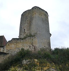 The ruins of the Château du Châtelier, in Paulmy | |
show Location of Paulmy | |
 Paulmy | |
| Coordinates: 46°58′59″N 0°50′24″E / 46.9831°N 0.84°ECoordinates: 46°58′59″N 0°50′24″E / 46.9831°N 0.84°E | |
| Country | France |
| Region | Centre-Val de Loire |
| Department | Indre-et-Loire |
| Arrondissement | Loches |
| Canton | Descartes |
| Intercommunality | CC Loches Sud Touraine |
| Government | |
| • Mayor (2020–2026) | Dominique Frelon |
| Area 1 | 25.97 km2 (10.03 sq mi) |
| Population (Jan. 2018)[1] | 233 |
| • Density | 9.0/km2 (23/sq mi) |
| Time zone | UTC+01:00 (CET) |
| • Summer (DST) | UTC+02:00 (CEST) |
| INSEE/Postal code | 37181 /37350 |
| Elevation | 72–127 m (236–417 ft) |
| 1 French Land Register data, which excludes lakes, ponds, glaciers > 1 km2 (0.386 sq mi or 247 acres) and river estuaries. | |


Paulmy (French pronunciation: [polmi]) is a commune in the Indre-et-Loire department in central France.
Population[]
| Year | Pop. | ±% |
|---|---|---|
| 1793 | 660 | — |
| 1800 | 700 | +6.1% |
| 1806 | 611 | −12.7% |
| 1821 | 704 | +15.2% |
| 1831 | 732 | +4.0% |
| 1836 | 753 | +2.9% |
| 1841 | 711 | −5.6% |
| 1846 | 729 | +2.5% |
| 1851 | 750 | +2.9% |
| 1856 | 713 | −4.9% |
| 1861 | 720 | +1.0% |
| 1866 | 692 | −3.9% |
| 1872 | 609 | −12.0% |
| 1876 | 619 | +1.6% |
| 1881 | 594 | −4.0% |
| 1886 | 611 | +2.9% |
| 1891 | 589 | −3.6% |
| 1896 | 568 | −3.6% |
| 1901 | 545 | −4.0% |
| 1906 | 543 | −0.4% |
| 1911 | 516 | −5.0% |
| 1921 | 514 | −0.4% |
| 1926 | 529 | +2.9% |
| 1931 | 603 | +14.0% |
| 1936 | 562 | −6.8% |
| 1946 | 538 | −4.3% |
| 1954 | 556 | +3.3% |
| 1962 | 519 | −6.7% |
| 1968 | 523 | +0.8% |
| 1975 | 437 | −16.4% |
| 1982 | 318 | −27.2% |
| 1990 | 269 | −15.4% |
| 1999 | 261 | −3.0% |
| 2006 | 259 | −0.8% |
| 2009 | 250 | −3.5% |
See also[]
References[]
- ^ "Populations légales 2018". INSEE. 28 December 2020.
| Wikimedia Commons has media related to Paulmy. |
| show Authority control |
|---|
This Indre-et-Loire geographical article is a stub. You can help Wikipedia by . |
Categories:
- Communes of Indre-et-Loire
- Indre-et-Loire geography stubs