Givry, Ardennes
This article may be expanded with text translated from the corresponding article in French. (December 2008) Click [show] for important translation instructions.
|
Givry | |
|---|---|
Commune | |
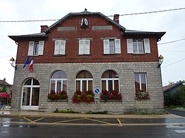 The town hall in Givry | |
 Coat of arms | |
Location of Givry  | |
 Givry | |
| Coordinates: 49°29′27″N 4°32′11″E / 49.4908°N 4.5364°ECoordinates: 49°29′27″N 4°32′11″E / 49.4908°N 4.5364°E | |
| Country | France |
| Region | Grand Est |
| Department | Ardennes |
| Arrondissement | Vouziers |
| Canton | Attigny |
| Intercommunality | Crêtes Préardennaises |
| Government | |
| • Mayor (2020–2026) | Xavier Fontaine |
| Area 1 | 11.93 km2 (4.61 sq mi) |
| Population (Jan. 2018)[1] | 272 |
| • Density | 23/km2 (59/sq mi) |
| Time zone | UTC+01:00 (CET) |
| • Summer (DST) | UTC+02:00 (CEST) |
| INSEE/Postal code | 08193 /08130 |
| Elevation | 77–107 m (253–351 ft) (avg. 80 m or 260 ft) |
| 1 French Land Register data, which excludes lakes, ponds, glaciers > 1 km2 (0.386 sq mi or 247 acres) and river estuaries. | |


Givry (French pronunciation: [ʒivʁi]) is a commune in the Ardennes department in northern France.
Population[]
| Year | Pop. | ±% |
|---|---|---|
| 1962 | 184 | — |
| 1968 | 245 | +33.2% |
| 1975 | 201 | −18.0% |
| 1982 | 199 | −1.0% |
| 1990 | 215 | +8.0% |
| 1999 | 218 | +1.4% |
| 2008 | 236 | +8.3% |
See also[]
References[]
- ^ "Populations légales 2018". The National Institute of Statistics and Economic Studies. 28 December 2020.
| Wikimedia Commons has media related to Givry, Ardennes. |
| Prefecture | |
|---|---|
| Subprefectures |
|
| Other |
|
This Ardennes geographical article is a stub. You can help Wikipedia by . |
Categories:
- Communes of Ardennes (department)
- Ardennes (department) geography stubs