Hierges
This article may be expanded with text translated from the corresponding article in French. (December 2008) Click [show] for important translation instructions.
|
Hierges | |
|---|---|
Commune | |
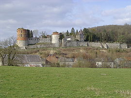 The chateau in Hierges | |
 Coat of arms | |
Location of Hierges  | |
 Hierges | |
| Coordinates: 50°06′21″N 4°44′26″E / 50.1058°N 4.7406°ECoordinates: 50°06′21″N 4°44′26″E / 50.1058°N 4.7406°E | |
| Country | France |
| Region | Grand Est |
| Department | Ardennes |
| Arrondissement | Charleville-Mézières |
| Canton | Givet |
| Intercommunality | Ardenne Rives de Meuse |
| Government | |
| • Mayor (2020–2026) | Isabelle Bodart[1] |
| Area 1 | 4.05 km2 (1.56 sq mi) |
| Population (Jan. 2018)[2] | 183 |
| • Density | 45/km2 (120/sq mi) |
| Time zone | UTC+01:00 (CET) |
| • Summer (DST) | UTC+02:00 (CEST) |
| INSEE/Postal code | 08226 /08320 |
| 1 French Land Register data, which excludes lakes, ponds, glaciers > 1 km2 (0.386 sq mi or 247 acres) and river estuaries. | |


Hierges is a commune in the Ardennes department in the Grand Est region in northern France.
Hierges is located in the Meuse valley along the Belgian border.
Population[]
| Year | Pop. | ±% |
|---|---|---|
| 1962 | 245 | — |
| 1968 | 297 | +21.2% |
| 1975 | 324 | +9.1% |
| 1982 | 300 | −7.4% |
| 1990 | 254 | −15.3% |
| 1999 | 220 | −13.4% |
| 2008 | 212 | −3.6% |
Sights and monuments[]
- Château de Hierges, a castle whose origins go back to the 16th century, was built on the site of an earlier 9th century castrum.
See also[]
- Manasses of Hierges
- Héribrand II of Hierges
- Communes of the Ardennes department
References[]
- ^ "Répertoire national des élus: les maires". data.gouv.fr, Plateforme ouverte des données publiques françaises (in French). 9 August 2021.
- ^ "Populations légales 2018". The National Institute of Statistics and Economic Studies. 28 December 2020.
| Wikimedia Commons has media related to Hierges. |
| Prefecture | |
|---|---|
| Subprefectures |
|
| Other |
|
This Ardennes geographical article is a stub. You can help Wikipedia by . |
Categories:
- Communes of Ardennes (department)
- Ardennes (department) geography stubs