Warnécourt
show This article may be expanded with text translated from the corresponding article in French. (December 2008) Click [show] for important translation instructions. |
Warnécourt | |
|---|---|
Commune | |
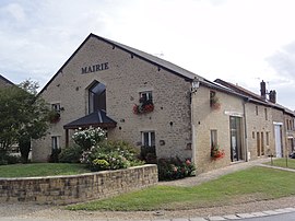 The town hall in Warnécourt | |
show Location of Warnécourt | |
 Warnécourt | |
| Coordinates: 49°44′01″N 4°39′02″E / 49.7336°N 4.6506°ECoordinates: 49°44′01″N 4°39′02″E / 49.7336°N 4.6506°E | |
| Country | France |
| Region | Grand Est |
| Department | Ardennes |
| Arrondissement | Charleville-Mézières |
| Canton | Nouvion-sur-Meuse |
| Intercommunality | |
| Government | |
| • Mayor (2020–2026) | Nicolas Poiret[1] |
| Area 1 | 5.36 km2 (2.07 sq mi) |
| Population (Jan. 2018)[2] | 379 |
| • Density | 71/km2 (180/sq mi) |
| Time zone | UTC+01:00 (CET) |
| • Summer (DST) | UTC+02:00 (CEST) |
| INSEE/Postal code | 08498 /08090 |
| 1 French Land Register data, which excludes lakes, ponds, glaciers > 1 km2 (0.386 sq mi or 247 acres) and river estuaries. | |


Warnécourt is a commune in the Ardennes department in northern France.
Population[]
| Year | Pop. | ±% |
|---|---|---|
| 2006 | 352 | — |
| 2007 | 362 | +2.8% |
| 2008 | 372 | +2.8% |
| 2009 | 382 | +2.7% |
| 2010 | 378 | −1.0% |
| 2011 | 376 | −0.5% |
| 2012 | 372 | −1.1% |
| 2013 | 367 | −1.3% |
| 2014 | 363 | −1.1% |
| 2015 | 364 | +0.3% |
| 2016 | 366 | +0.5% |
See also[]
References[]
- ^ "Répertoire national des élus: les maires". data.gouv.fr, Plateforme ouverte des données publiques françaises (in French). 2 December 2020.
- ^ "Populations légales 2018". INSEE. 28 December 2020.
| Wikimedia Commons has media related to Warnécourt. |
This Ardennes geographical article is a stub. You can help Wikipedia by . |
Categories:
- Communes of Ardennes (department)
- Ardennes (department) geography stubs