Gontaud-de-Nogaret
Gontaud-de-Nogaret | |
|---|---|
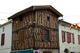 A half-timbered house in Gontaud-de-Nogaret | |
 Coat of arms | |
show Location of Gontaud-de-Nogaret | |
 Gontaud-de-Nogaret | |
| Coordinates: 44°27′25″N 0°17′44″E / 44.4569°N 0.2956°ECoordinates: 44°27′25″N 0°17′44″E / 44.4569°N 0.2956°E | |
| Country | France |
| Region | Nouvelle-Aquitaine |
| Department | Lot-et-Garonne |
| Arrondissement | Marmande |
| Canton | Marmande-2 |
| Intercommunality | CA Val de Garonne |
| Government | |
| • Mayor (2020–2026) | Christian Jambon[1] |
| Area 1 | 29.51 km2 (11.39 sq mi) |
| Population (Jan. 2018)[2] | 1,673 |
| • Density | 57/km2 (150/sq mi) |
| Time zone | UTC+01:00 (CET) |
| • Summer (DST) | UTC+02:00 (CEST) |
| INSEE/Postal code | 47110 /47400 |
| Elevation | 26–132 m (85–433 ft) (avg. 45 m or 148 ft) |
| 1 French Land Register data, which excludes lakes, ponds, glaciers > 1 km2 (0.386 sq mi or 247 acres) and river estuaries. | |


Gontaud-de-Nogaret is a commune in the Lot-et-Garonne department in south-western France.
People[]
The village was the home of Henri Pépin, a prosperous houseowner and cycling enthusiast who employed two helpers to pace him around the Tour de France in 1906. Pépin—sometimes wrongly described as a baron—had no interest in winning the race. Instead, he paid his helpers to lead him to the best restaurants and hotels they could find. Some days they finished more than 12 hours behind the winner.
See also[]
References[]
- ^ "Répertoire national des élus: les maires". data.gouv.fr, Plateforme ouverte des données publiques françaises (in French). 2 December 2020.
- ^ "Populations légales 2018". INSEE. 28 December 2020.
| Wikimedia Commons has media related to Gontaud-de-Nogaret. |
| show Authority control |
|---|
This Lot-et-Garonne geographical article is a stub. You can help Wikipedia by . |
Categories:
- Communes of Lot-et-Garonne
- Lot-et-Garonne geography stubs