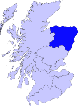
Grampian
This article does not cite any sources. (December 2009) |
Grampian
Roinn a' Mhonaidh | |
|---|---|
 | |
| Government | |
| • Type | Regional Council |
| Area | |
| • Total | 8,697.72 km2 (3,358.21 sq mi) |
| Area rank | Ranked 3rd |
| Population | |
| • Estimate (2020) | 584,550 |
| • Rank | Ranked 3rd |
Grampian (Scottish Gaelic: Roinn a' Mhonaidh) was one of nine former local government regions of Scotland created in 1975 by the Local Government (Scotland) Act 1973 and abolished in 1996 by the Local Government etc. (Scotland) Act 1994. It is now divided into the unitary council areas of:
- Aberdeenshire
- City of Aberdeen
- Moray
It is made up of the historical counties of:
- Aberdeenshire
- City of Aberdeen
- Kincardineshire
- Morayshire
The region had five districts:
Geography[]
Name[]

The region took its name from the Grampian Mountains.
Largest Cities and Towns[]
- Aberdeen
- Elgin
- Peterhead
- Fraserburgh
- Inverurie
- Westhill
- Stonehaven
- Forres
- Ellon
 Aberdeen Beach
 - Portlethen

Boundaires[]
Grampian has boundaries with the Highlands to the east (Inverness-shire, Nairnshire) and Tayside to the south (Angus, Perth and Kinross).
The region of Grampian was made up of the regions of:
- Aberdeenshire
- City of Aberdeen
- Kincardineshire (Historical county, Incorporated into Aberdeenshire)
- Moray (Morayshire)
- Banffshire (Historical county, Incorporated into Moray)
Politics[]
Electoral History[]
| Election | Party |
|---|---|
| 1982 | Conservative |
| 1986 | Labour |
| 1990 | Labour |
| 1994 | Liberal Democrats |

1982 results map

1986 results map
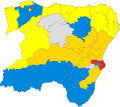
1990 results map

1994 Scotland results


Modern day use[]
Grampian continues to have a regional NHS board. The region also had a regional fire and rescue service and Police service before they were merged into Scottish Fire and Rescue Service and Police Scotland respectively. Grampian also had its own Television region called Grampian Television until it was dissolved and incorporated in STV North in 2006.
Gallery[]
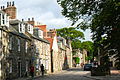
Street in Old Aberdeen

Plainstones in Elgin


Town twinning[]
See also[]
External links[]
 Media related to Grampian at Wikimedia Commons
Local government areas of Scotland, in use 1973 to 1996 | ||
|---|---|---|
| Borders |
|  |
| Central Region | ||
| Dumfries and Galloway |
| |
| Fife | ||
| Grampian |
| |
| Highland |
| |
| Lothian |
| |
| Strathclyde |
| |
| Tayside |
| |
| Island areas1 | ||

- Grampian
- Regions of Scotland
- 1975 establishments in Scotland
- 1996 disestablishments in Scotland