Greenwood, Florida
Greenwood, Florida | |
|---|---|
 Town Hall | |
 Location in Jackson County and the state of Florida | |
| Coordinates: 30°52′25″N 85°9′45″W / 30.87361°N 85.16250°WCoordinates: 30°52′25″N 85°9′45″W / 30.87361°N 85.16250°W | |
| Country | |
| State | |
| County | Jackson |
| Government | |
| • Type | |
| Area | |
| • Total | 4.56 sq mi (11.82 km2) |
| • Land | 4.56 sq mi (11.82 km2) |
| • Water | 0.00 sq mi (0.00 km2) |
| Elevation | 115 ft (35 m) |
| Population (2010) | |
| • Total | 686 |
| • Estimate (2019)[4] | 662 |
| • Density | 145.05/sq mi (56.00/km2) |
| Time zone | UTC-6 (Central (CST)) |
| • Summer (DST) | UTC-5 (CDT) |
| ZIP code | 32443 |
| Area code(s) | 850 |
| FIPS code | 12-27600[2] |
| GNIS feature ID | 0283427[3] |
| Website | www |

Greenwood is a town in Jackson County, Florida, United States. The population was 686 at the 2010 census.
Geography[]
Greenwood is located at 30°52′25″N 85°9′45″W / 30.87361°N 85.16250°W (30.873517, -85.162431).[5]
According to the United States Census Bureau, the town has a total area of 4.8 square miles (12 km2), all land. Greenwood is ten miles from the county seat, Marianna, and the town of Malone. Both are much larger than Greenwood, and most residents of the area go to school or work in either of those two towns.
Demographics[]
| Historical population | |||
|---|---|---|---|
| Census | Pop. | %± | |
| 1940 | 293 | — | |
| 1960 | 427 | — | |
| 1970 | 449 | 5.2% | |
| 1980 | 577 | 28.5% | |
| 1990 | 474 | −17.9% | |
| 2000 | 735 | 55.1% | |
| 2010 | 686 | −6.7% | |
| 2019 (est.) | 662 | [4] | −3.5% |
| U.S. Decennial Census[6] | |||
As of the census[2] of 2000, there were 735 people, 296 households, and 200 families residing in the town. The population density was 153.3 inhabitants per square mile (59.1/km2). There were 335 housing units at an average density of 69.9 per square mile (26.9/km2). The racial makeup of the town was 66.67% White, 26.94% African American, 1.22% Native American, 0.95% Asian, 1.90% from other races, and 2.31% from two or more races. Hispanic or Latino of any race were 2.72% of the population.
There were 300 households, out of which 29.1% had children under the age of 18 living with them, 52.4% were married couples living together, 11.8% had a female householder with no husband present, and 32.1% were non-families. 29.4% of all households were made up of individuals, and 13.5% had someone living alone who was 65 years of age or older. The average household size was 2.44 and the average family size was 2.99.
In the town, the population was spread out, with 26.4% under the age of 18, 7.2% from 18 to 24, 24.6% from 25 to 44, 25.0% from 45 to 64, and 16.7% who were 65 years of age or older. The median age was 38 years. For every 100 females, there were 87.0 males. For every 100 females age 18 and over, there were 89.8 males.
The median income for a household in the town was $28,750, and the median income for a family was $35,750. Males had a median income of $24,583 versus $22,083 for females. The per capita income for the town was $14,243. About 9.1% of families and 17.8% of the population were below the poverty line, including 21.6% of those under age 18 and 11.6% of those age 65 or over.
Gallery[]
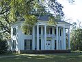
Great Oaks, Bryan Plantation
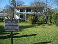
Historic Erwin House

Historic Penders Store


References[]
- ^ "2019 U.S. Gazetteer Files". United States Census Bureau. Retrieved July 2, 2020.
- ^ Jump up to: a b "U.S. Census website". United States Census Bureau. Retrieved 2008-01-31.
- ^ "US Board on Geographic Names". United States Geological Survey. 2007-10-25. Retrieved 2008-01-31.
- ^ Jump up to: a b "Population and Housing Unit Estimates". United States Census Bureau. May 24, 2020. Retrieved May 27, 2020.
- ^ "US Gazetteer files: 2010, 2000, and 1990". United States Census Bureau. 2011-02-12. Retrieved 2011-04-23.
- ^ "Census of Population and Housing". Census.gov. Retrieved June 4, 2015.
| show Municipalities and communities of Jackson County, Florida, United States |
|---|

| show Authority control |
|---|
- Towns in Jackson County, Florida
- Towns in Florida