Hales Corners, Wisconsin
Hales Corners, Wisconsin | |
|---|---|
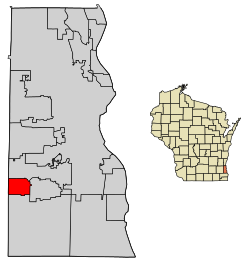 Location of Hales Corners in Milwaukee County, Wisconsin. | |
| Coordinates: 42°56′29″N 88°3′4″W / 42.94139°N 88.05111°WCoordinates: 42°56′29″N 88°3′4″W / 42.94139°N 88.05111°W | |
| Country | |
| State | |
| County | Milwaukee |
| Area | |
| • Total | 3.20 sq mi (8.28 km2) |
| • Land | 3.19 sq mi (8.27 km2) |
| • Water | 0.01 sq mi (0.02 km2) |
| Elevation | 781 ft (238 m) |
| Population | |
| • Total | 7,692 |
| • Estimate (2019)[5] | 7,567 |
| • Density | 2,370.61/sq mi (915.37/km2) |
| Time zone | UTC-6 (Central (CST)) |
| • Summer (DST) | UTC-5 (CDT) |
| Area code(s) | 414 |
| FIPS code | 55-32075[4] |
| GNIS feature ID | 1565971[3] |
| Website | www |

Hales Corners is a village in Milwaukee County, Wisconsin, United States. The population was 7,692 at the 2010 census.
Geography[]
Hales Corners is located in southwestern Milwaukee County. It is bounded by Greenfield on the north, Greendale on the east, Franklin on the south, and New Berlin and Muskego in Waukesha County on the west.
According to the United States Census Bureau, the village has a total area of 3.22 square miles (8.34 km2), of which, 3.21 square miles (8.31 km2) of it is land and 0.01 square miles (0.03 km2) is water.[6]
Demographics[]
| Historical population | |||
|---|---|---|---|
| Census | Pop. | %± | |
| 1960 | 5,549 | — | |
| 1970 | 7,771 | 40.0% | |
| 1980 | 7,110 | −8.5% | |
| 1990 | 7,623 | 7.2% | |
| 2000 | 7,765 | 1.9% | |
| 2010 | 7,692 | −0.9% | |
| 2019 (est.) | 7,567 | [5] | −1.6% |
| U.S. Decennial Census[7] | |||
2010 census[]
As of the census[2] of 2010, there were 7,692 people, 3,301 households, and 2,066 families living in the village. The population density was 2,396.3 inhabitants per square mile (925.2/km2). There were 3,505 housing units at an average density of 1,091.9 per square mile (421.6/km2). The racial makeup of the village was 94.7% White, 1.0% African American, 0.5% Native American, 1.7% Asian, 0.9% from other races, and 1.2% from two or more races. Hispanic or Latino of any race were 4.3% of the population.
There were 3,301 households, of which 27.3% had children under the age of 18 living with them, 49.1% were married couples living together, 9.8% had a female householder with no husband present, 3.6% had a male householder with no wife present, and 37.4% were non-families. 31.6% of all households were made up of individuals, and 14.6% had someone living alone who was 65 years of age or older. The average household size was 2.31 and the average family size was 2.91.
The median age in the village was 43.9 years. 20.8% of residents were under the age of 18; 8.2% were between the ages of 18 and 24; 22.6% were from 25 to 44; 29.9% were from 45 to 64; and 18.5% were 65 years of age or older. The gender makeup of the village was 47.6% male and 52.4% female.
2000 census[]
As of the census[4] of 2000, there were 7,765 people, 3,260 households, and 2,122 families living in the village. The population density was 2,424.7 people per square mile (936.9/km2). There were 3,377 housing units at an average density of 1,054.5 per square mile (407.5/km2). The racial makeup of the village was 97.15% White, 0.22% African American, 0.49% Native American, 0.97% Asian, 0.04% Pacific Islander, 0.57% from other races, and 0.57% from two or more races. Hispanic or Latino of any race were 2.09% of the population.
There were 3,260 households, out of which 27.4% had children under the age of 18 living with them, 53.8% were married couples living together, 8.5% had a female householder with no husband present, and 34.9% were non-families. 29.1% of all households were made up of individuals, and 12.6% had someone living alone who was 65 years of age or older. The average household size was 2.35 and the average family size was 2.93.
In the village, the population was spread out, with 22.1% under the age of 18, 7.2% from 18 to 24, 28.1% from 25 to 44, 24.2% from 45 to 64, and 18.5% who were 65 years of age or older. The median age was 41 years. For every 100 females, there were 91.1 males. For every 100 females age 18 and over, there were 87.9 males.
The median income for a household in the village was $54,536, and the median income for a family was $66,136. Males had a median income of $42,175 versus $33,237 for females. The per capita income for the village was $25,354. About 0.3% of families and 2.0% of the population were below the poverty line, including 0.6% of those under age 18 and 5.0% of those age 65 or over.
Education[]
The Whitnall School District serves Hales Corners.[8]
- Edgerton Elementary School
- Hales Corners Elementary School
Private schools:
- Hales Corners Lutheran School
- Messiah Lutheran School
- St. Mary Parish School
Post-secondary:
Points of interest[]
- Boerner Botanical Gardens
- Audacy Milwaukee studios (WMYX, WSSP and WXSS)
- Hales Corners Chamber of Commerce[9]
- Hales Corners Historical Society (including W. Ben Hunt Cabin)[10]
- Hales Corners Library[11]
- Hales Corners Lutheran Church
- St. Mary Catholic Church[12]
- Hales Corners Speedway
Notable people[]
- Zeke Dombrowski, soccer player
- Alyson Dudek, two-time Olympian 2010 (bronze medal) and 2014 short track speed skater
- W. Ben Hunt (1888–1970) educator and author[13]
- Gordon Gano, frontman of the rock band Violet Femmes
- Jim Gantner, MLB player
- Barbara Lawton, Lieutenant Governor of Wisconsin
- Paul and Tom Poberezny, former heads of the Experimental Aircraft Association and members of the National Aviation Hall of Fame
- Roy Reiman, founder of Reiman Publications
- James A. Rutkowski, Wisconsin State Representative
- Wilfred Schuele, Wisconsin State Senator
See also[]
References[]
- ^ "2019 U.S. Gazetteer Files". United States Census Bureau. Retrieved August 7, 2020.
- ^ Jump up to: a b "U.S. Census website". United States Census Bureau. Retrieved November 18, 2012.
- ^ Jump up to: a b "US Board on Geographic Names". United States Geological Survey. October 25, 2007. Retrieved January 31, 2008.
- ^ Jump up to: a b "U.S. Census website". United States Census Bureau. Retrieved January 31, 2008.
- ^ Jump up to: a b "Population and Housing Unit Estimates". United States Census Bureau. May 24, 2020. Retrieved May 27, 2020.
- ^ "US Gazetteer files 2010". United States Census Bureau. Retrieved November 18, 2012.
- ^ "Census of Population and Housing". Census.gov. Retrieved June 4, 2015.
- ^ "About Whitnall Archived July 12, 2014, at the Wayback Machine." Whitnall School District. Retrieved on April 19, 2014.
- ^ ":: The Hales Corners Chamber of Commerce ::". HalesCornersChamber.org. Retrieved February 4, 2017.
- ^ Kochis, Michael. "index". HistoricHalesCorners.org. Retrieved February 4, 2017.
- ^ "Hales Corners Library Home page". mcfls.org. Retrieved February 4, 2017.
- ^ St. Mary Catholic Church
- ^ Kochis, Michael. "HCHS4". HistoricHalesCorners.org. Archived from the original on July 18, 2014. Retrieved February 4, 2017.
External links[]
| Wikimedia Commons has media related to Hales Corners, Wisconsin. |
| show Municipalities and communities of Milwaukee County, Wisconsin, United States |
|---|


| show Authority control |
|---|
- Villages in Milwaukee County, Wisconsin
- Villages in Wisconsin