Hallowell, Kansas
Hallowell, Kansas | |
|---|---|
 | |
 Hallowell | |
| Coordinates: 37°10′29″N 94°59′44″W / 37.17472°N 94.99556°WCoordinates: 37°10′29″N 94°59′44″W / 37.17472°N 94.99556°W[1] | |
| Country | United States |
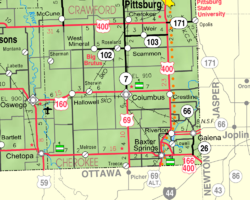
| State | Kansas |
| County | Cherokee |
| Elevation | 840 ft (260 m) |
| Time zone | UTC-6 (CST) |
| • Summer (DST) | UTC-5 (CDT) |
| Area code | 620 |
| FIPS code | 20-29550 [1] |
| GNIS ID | 469477 [1] |


Hallowell is an unincorporated community in Cherokee County, Kansas, United States.[1][2]
History[]
Hallowell was a station on the St. Louis–San Francisco Railway.[3]
Demographics[]
For statistical purposes, the United States Census Bureau has defined this community as a census-designated place (CDP).
References[]
- ^ a b c d e Geographic Names Information System (GNIS) details for Hallowell, Kansas; United States Geological Survey (USGS); October 13, 1978.
- ^ Connelley, William Elsey (1918). A standard history of Kansas and Kansans, Volume 5. Chicago: Lewis. p. 2326.
- ^ Blackmar, Frank Wilson (1912). Kansas: A Cyclopedia of State History, Embracing Events, Institutions, Industries, Counties, Cities, Towns, Prominent Persons, Etc. Standard Publishing Company. pp. 802.
Further reading[]
External links[]
Municipalities and communities of Cherokee County, Kansas, United States | ||
|---|---|---|
| Cities |  | |
| Unincorporated communities | ||
| Ghost towns | ||
| Townships | ||
| Footnotes | †This populated place is designated a Census-Designated Place (CDP) by the United States Census Bureau. ‡This populated place also has portions in an adjacent county or counties. | |
| ||
Categories:
- Unincorporated communities in Cherokee County, Kansas
- Unincorporated communities in Kansas
- Southeast Kansas geography stubs