Scammon, Kansas
Scammon, Kansas | |
|---|---|
 Scammon, circa 1900-1910 | |
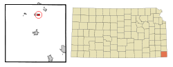 Location within Cherokee County and Kansas | |
 | |
| Coordinates: 37°16′42″N 94°49′16″W / 37.27833°N 94.82111°WCoordinates: 37°16′42″N 94°49′16″W / 37.27833°N 94.82111°W | |
| Country | United States |
| State | Kansas |
| County | Cherokee |
| Founded | 1884 |
| Platted | 1884 |
| Incorporated | 1888 |
| Named for | Scammon brothers |
| Government | |
| • Mayor | Jerry Grant |
| Area | |
| • Total | 0.63 sq mi (1.63 km2) |
| • Land | 0.63 sq mi (1.62 km2) |
| • Water | 0.00 sq mi (0.01 km2) |
| Elevation | 899 ft (274 m) |
| Population | |
| • Total | 482 |
| • Estimate (2019)[3] | 444 |
| • Density | 708.13/sq mi (273.43/km2) |
| Time zone | UTC-6 (CST) |
| • Summer (DST) | UTC-5 (CDT) |
| ZIP code | 66773 |
| Area code | 620 |
| FIPS code | 20-63325 [4] |
| GNIS ID | 469615 [5] |
| Website | City website |

Scammon is a city in Cherokee County, Kansas, United States. As of the 2010 census, the city population was 482.[6]
History[]
Scammon was laid out in 1884.[7] It was named for the four Scammon brothers, who operated the first mine there.[8] David Mackie (1836–1910) was a founder and builder of Scammon, and the first President of the Scammon State Bank.[9] The community was known as Stilson when it was first settled. The town was known as Scammonville for a short time before adopting the current name.[10]
The first post office at Scammonville, established in 1879, was renamed Scammon in 1890.[11]
The local railroad history group Heart of the Heartlands, based in Scammon and nearby unincorporated Carona, has restored the old Carona depot as a museum.[12]
Geography[]
According to the United States Census Bureau, the city has a total area of 0.64 square miles (1.66 km2), all of it land.[13]
Demographics[]
| Historical population | |||
|---|---|---|---|
| Census | Pop. | %± | |
| 1890 | 748 | — | |
| 1900 | 1,549 | 107.1% | |
| 1910 | 2,233 | 44.2% | |
| 1920 | 1,694 | −24.1% | |
| 1930 | 1,093 | −35.5% | |
| 1940 | 737 | −32.6% | |
| 1950 | 561 | −23.9% | |
| 1960 | 429 | −23.5% | |
| 1970 | 457 | 6.5% | |
| 1980 | 501 | 9.6% | |
| 1990 | 466 | −7.0% | |
| 2000 | 496 | 6.4% | |
| 2010 | 482 | −2.8% | |
| 2019 (est.) | 444 | [3] | −7.9% |
| U.S. Decennial Census | |||
2010 census[]
As of the census[2] of 2010, there were 482 people, 192 households, and 128 families living in the city. The population density was 753.1 inhabitants per square mile (290.8/km2). There were 219 housing units at an average density of 342.2 per square mile (132.1/km2). The racial makeup of the city was 94.8% White, 0.8% Native American, 0.8% Asian, 1.0% from other races, and 2.5% from two or more races. Hispanic or Latino of any race were 1.5% of the population.
There were 192 households, of which 37.5% had children under the age of 18 living with them, 51.6% were married couples living together, 11.5% had a female householder with no husband present, 3.6% had a male householder with no wife present, and 33.3% were non-families. 26.6% of all households were made up of individuals, and 8.8% had someone living alone who was 65 years of age or older. The average household size was 2.51 and the average family size was 3.09.
The median age in the city was 39.6 years. 27.2% of residents were under the age of 18; 8.6% were between the ages of 18 and 24; 23.6% were from 25 to 44; 27.5% were from 45 to 64; and 12.9% were 65 years of age or older. The gender makeup of the city was 48.8% male and 51.2% female.
2000 census[]
As of the census[4] of 2000, there were 496 people, 192 households, and 139 families living in the city. The population density was 782.4 people per square mile (304.0/km2). There were 222 housing units at an average density of 350.2 per square mile (136.1/km2). The racial makeup of the city was 93.75% White, 0.60% African American, 2.42% Native American, 0.60% Asian, and 2.62% from two or more races. Hispanic or Latino of any race were 0.60% of the population.
There were 192 households, out of which 36.5% had children under the age of 18 living with them, 55.2% were married couples living together, 15.1% had a female householder with no husband present, and 27.6% were non-families. 26.6% of all households were made up of individuals, and 12.0% had someone living alone who was 65 years of age or older. The average household size was 2.58 and the average family size was 3.12.
In the city, the population was spread out, with 29.0% under the age of 18, 8.7% from 18 to 24, 29.4% from 25 to 44, 19.4% from 45 to 64, and 13.5% who were 65 years of age or older. The median age was 34 years. For every 100 females, there were 98.4 males. For every 100 females age 18 and over, there were 85.3 males.
The median income for a household in the city was $35,268, and the median income for a family was $37,708. Males had a median income of $29,219 versus $21,477 for females. The per capita income for the city was $15,926. About 11.3% of families and 12.8% of the population were below the poverty line, including 27.8% of those under age 18 and 4.1% of those age 65 or over.
Notable people[]
- George Barr, umpire.
- Rube Ferns, boxer.[14]
- Fred McMullin, baseball player.
References[]
- ^ "2019 U.S. Gazetteer Files". United States Census Bureau. Retrieved July 24, 2020.
- ^ a b "U.S. Census website". United States Census Bureau. Retrieved 2012-07-06.
- ^ a b "Population and Housing Unit Estimates". United States Census Bureau. May 24, 2020. Retrieved May 27, 2020.
- ^ a b "U.S. Census website". United States Census Bureau. Retrieved 2008-01-31.
- ^ "US Board on Geographic Names". United States Geological Survey. 2007-10-25. Retrieved 2008-01-31.
- ^ "2010 City Population and Housing Occupancy Status". U.S. Census Bureau. Retrieved December 3, 2011.[dead link]
- ^ Kansas State Historical Society (1916). Biennial Report of the Board of Directors of the Kansas State Historical Society. Kansas State Printing Plant. pp. 157.
- ^ "Profile for Scammon, Kansas". ePodunk. Retrieved 6 June 2014.
- ^ Blackmar, Frank Wilson (1912). Kansas: a cyclopedia of state history, embracing events, institutions, industries, counties, cities, towns, prominent persons, etc. ... with a supplementary volume devoted to selected personal history and reminiscence (Public domain ed.). Standard publishing company. pp. 482–. Retrieved 19 February 2012.
- ^ Kansas Place-Names,John Rydjord, University of Oklahoma Press, 1972, ISBN 0-8061-0994-7
- ^ "Kansas Post Offices, 1828-1961, page 2". Kansas Historical Society. Retrieved 6 June 2014.
- ^ Untitled Document, Heart of the Heartlands. Accessed 2007-08-07.
- ^ "US Gazetteer files 2010". United States Census Bureau. Archived from the original on 2012-01-25. Retrieved 2012-07-06.
- ^ Rube Ferns at BoxRec
Further reading[]
- The Story of the City of Scammon; Leona Spice; 1976.
External links[]
| Wikimedia Commons has media related to Scammon, Kansas. |
- City of Scammon
- Scammon - Directory of Public Officials
- USD 493, local school district
- Historic Images of Scammon, Special Photo Collections at Wichita State University Library
- Scammon city map, KDOT
Municipalities and communities of Cherokee County, Kansas, United States | ||
|---|---|---|
| Cities |  | |
| Unincorporated communities | ||
| Ghost towns | ||
| Townships | ||
| Footnotes | †This community is designated a Census-Designated Place (CDP) by the United States Census Bureau. ‡This community also has portions in an adjacent county or counties. | |
| ||
- Cities in Kansas
- Cities in Cherokee County, Kansas