Horní Branná
Horní Branná | |
|---|---|
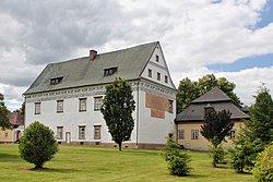 Horní Branná Palace | |
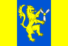 Flag 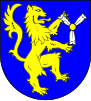 Coat of arms | |
 Horní Branná Location in the Czech Republic | |
| Coordinates: 50°36′30″N 15°34′18″E / 50.60833°N 15.57167°ECoordinates: 50°36′30″N 15°34′18″E / 50.60833°N 15.57167°E | |
| Country | |
| Region | Liberec |
| District | Semily |
| First mentioned | 1357 |
| Area | |
| • Total | 20.86 km2 (8.05 sq mi) |
| Elevation | 459 m (1,506 ft) |
| Population (2021-01-01)[1] | |
| • Total | 1,897 |
| • Density | 91/km2 (240/sq mi) |
| Time zone | UTC+1 (CET) |
| • Summer (DST) | UTC+2 (CEST) |
| Postal codes | 512 36, 514 01 |
| Website | www |

Horní Branná (German: Brennei) is a municipality and village in Semily District in the Liberec Region of the Czech Republic. It has about 1,900 inhabitants.
Administrative parts[]
The village of Valteřice is an administrative part of Lubenec.
Notable people[]
- František Hák (1903–?), cross-country skier
- Václav Jón (1905–1966), cross-country skier
- Zdeněk Remsa (1928–2019), ski jumper
- Ilja Matouš (1931–2018), cross-country skier
References[]
External links[]
| Wikimedia Commons has media related to Horní Branná. |
| Authority control: National libraries |
|---|
This Liberec Region location article is a stub. You can help Wikipedia by . |
Categories:
- Populated places in Semily District
- Villages in Semily District
- Liberec Region geography stubs