Ohrazenice (Semily District)
Ohrazenice | |
|---|---|
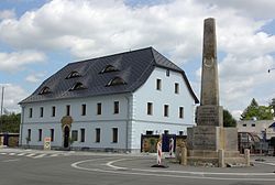 Stone guidepost from 1813 and former inn "U Pyrámu" from 1819 | |
 Flag  Coat of arms | |
 Ohrazenice Location in the Czech Republic | |
| Coordinates: 50°35′52″N 15°7′34″E / 50.59778°N 15.12611°ECoordinates: 50°35′52″N 15°7′34″E / 50.59778°N 15.12611°E | |
| Country | |
| Region | Liberec |
| District | Semily |
| First mentioned | 1543 |
| Area | |
| • Total | 2.69 km2 (1.04 sq mi) |
| Elevation | 256 m (840 ft) |
| Population (2021-01-01)[1] | |
| • Total | 1,126 |
| • Density | 420/km2 (1,100/sq mi) |
| Time zone | UTC+1 (CET) |
| • Summer (DST) | UTC+2 (CEST) |
| Postal code | 511 01 |
| Website | www |

Ohrazenice is a municipality and village in Semily District in the Liberec Region of the Czech Republic. It has about 1,100 inhabitants.
References[]
| Authority control: National libraries |
|---|
Categories:
- Populated places in Semily District
- Villages in Semily District
- Příbram geography stubs