Slaná (Semily District)
Slaná | |
|---|---|
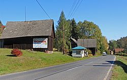 Hořensko, a part of Slaná | |
 Flag  Coat of arms | |
 Slaná Location in the Czech Republic | |
| Coordinates: 50°34′51″N 15°19′47″E / 50.58083°N 15.32972°ECoordinates: 50°34′51″N 15°19′47″E / 50.58083°N 15.32972°E | |
| Country | |
| Region | Liberec |
| District | Semily |
| First mentioned | 1430 |
| Area | |
| • Total | 10.26 km2 (3.96 sq mi) |
| Elevation | 358 m (1,175 ft) |
| Population (2021-01-01)[1] | |
| • Total | 664 |
| • Density | 65/km2 (170/sq mi) |
| Time zone | UTC+1 (CET) |
| • Summer (DST) | UTC+2 (CEST) |
| Postal code | 512 01 |
| Website | www |

Slaná is a municipality and village in Semily District in the Liberec Region of the Czech Republic. It has about 700 inhabitants.
Administrative parts[]
Villages of Bořkov, Hořensko, Nedvězí, Sutice and Světlá are administrative parts of Slaná.
History[]
The first written mention of Slaná is from 1430.[2]
References[]
- ^ "Population of Municipalities – 1 January 2021". Czech Statistical Office. 2021-04-30.
- ^ "Historie obce" (in Czech). Obec Slaná. Retrieved 2021-08-20.
| Authority control: National libraries |
|---|
This Liberec Region location article is a stub. You can help Wikipedia by . |
Categories:
- Populated places in Semily District
- Villages in Semily District
- Liberec Region geography stubs