Studenec (Semily District)
Studenec | |
|---|---|
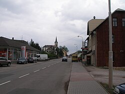 Main road and Church of Saint John the Baptist | |
 Flag  Coat of arms | |
 Studenec Location in the Czech Republic | |
| Coordinates: 50°33′13″N 15°32′58″E / 50.55361°N 15.54944°ECoordinates: 50°33′13″N 15°32′58″E / 50.55361°N 15.54944°E | |
| Country | |
| Region | Liberec |
| District | Semily |
| First mentioned | 1388 |
| Area | |
| • Total | 16.87 km2 (6.51 sq mi) |
| Elevation | 514 m (1,686 ft) |
| Population (2021-01-01)[1] | |
| • Total | 1,898 |
| • Density | 110/km2 (290/sq mi) |
| Time zone | UTC+1 (CET) |
| • Summer (DST) | UTC+2 (CEST) |
| Postal codes | 512 33, 514 01 |
| Website | www |

Studenec is a municipality and village in Semily District in the Liberec Region of the Czech Republic. It has about 1,900 inhabitants.
Administrative parts[]
Villages of Rovnáčov and Zálesní Lhota are administrative parts of Studenec.
Geography[]
The highest peak in the municipality is Stráž with an altitude of 630 metres (2,070 ft). The river Oleška springs in Rovnáčov and flows through the municipality.
Notable people[]
- Jiří Šlitr (1924–1969), songwriter, pianist, singer, actor
- Květa Jeriová (born 1956), cross-country skier
Twin towns – sister cities[]
 Zuberec, Slovakia
References[]
- ^ "Population of Municipalities – 1 January 2021". Czech Statistical Office. 2021-04-30.
- ^ "Úvodní strana" (in Czech). Obec Studenec. Retrieved 2020-08-14.
| Wikimedia Commons has media related to Studenec (Semily District). |
| show Authority control |
|---|
This Liberec Region location article is a stub. You can help Wikipedia by . |
Categories:
- Populated places in Semily District
- Villages in Semily District
- Liberec Region geography stubs