Horní Kamenice
Horní Kamenice | |
|---|---|
 Municipal office and chapel (left) | |
 Flag  Coat of arms | |
 Horní Kamenice Location in the Czech Republic | |
| Coordinates: 49°34′11″N 13°6′4″E / 49.56972°N 13.10111°ECoordinates: 49°34′11″N 13°6′4″E / 49.56972°N 13.10111°E | |
| Country | |
| Region | Plzeň |
| District | Plzeň-South |
| First mentioned | 1115 |
| Area | |
| • Total | 3.85 km2 (1.49 sq mi) |
| Elevation | 377 m (1,237 ft) |
| Population (2021-01-01)[1] | |
| • Total | 252 |
| • Density | 65/km2 (170/sq mi) |
| Time zone | UTC+1 (CET) |
| • Summer (DST) | UTC+2 (CEST) |
| Postal code | 345 62 |
| Website | hornikamenice |

Horní Kamenice is a municipality and village in Plzeň-South District in the Plzeň Region of the Czech Republic. It has about 300 inhabitants.
Geography[]
Horní Kamenice is located in the valley of the river Radbuza and west of Výtůň forest. Through the municipality flows the Srbický Creek. Horní Kamenice lies approximately 19 kilometres (12 mi) north-east of Domažlice, 29 km (18 mi) south-west of Plzeň, and 112 km (70 mi) south-west of Prague.
History[]
The first written mention of Horní Kamenice is from 1115.[2]
From 1 January 2021, Horní Kamenice is no longer a part of Domažlice District and belongs to Plzeň-South District.[3]
Gallery[]
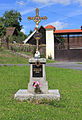
Crucifix in Horní Kamenice
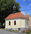
Chapel in Horní Kamenice

Village view


References[]
- ^ "Population of Municipalities – 1 January 2021". Czech Statistical Office. 2021-04-30.
- ^ "Souhrné informace" (in Czech). Obec Horní Kamenice. Retrieved 2021-05-24.
- ^ "Obecně o novém zákonu č. 51/2020 Sb". mvcr.cz (in Czech). Ministry of the interior of the Czech Republic. Retrieved 2021-05-24.
External links[]
| Wikimedia Commons has media related to Horní Kamenice (Plzeň-South District). |
| Authority control: National libraries |
|---|
This Plzeň Region location article is a stub. You can help Wikipedia by . |
- Villages in Plzeň-South District
- Plzeň Region geography stubs