Horní Libchava
Horní Libchava | |
|---|---|
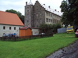 Horní Libchava Castle | |
 Flag  Coat of arms | |
 Horní Libchava Location in the Czech Republic | |
| Coordinates: 50°42′46″N 14°29′36″E / 50.71278°N 14.49333°ECoordinates: 50°42′46″N 14°29′36″E / 50.71278°N 14.49333°E | |
| Country | |
| Region | Liberec |
| District | Česká Lípa |
| First mentioned | 1352 |
| Area | |
| • Total | 10.38 km2 (4.01 sq mi) |
| Elevation | 258 m (846 ft) |
| Population (2021-01-01)[1] | |
| • Total | 809 |
| • Density | 78/km2 (200/sq mi) |
| Time zone | UTC+1 (CET) |
| • Summer (DST) | UTC+2 (CEST) |
| Postal code | 471 11 |
| Website | www |

Horní Libchava (German: Oberliebich) is a municipality and village in Česká Lípa District in the Liberec Region of the Czech Republic. It has about 800 inhabitants.
References[]
| Wikimedia Commons has media related to Horní Libchava. |
| show Authority control |
|---|
This Liberec Region location article is a stub. You can help Wikipedia by . |
Categories:
- Populated places in Česká Lípa District
- Villages in Česká Lípa District
- Liberec Region geography stubs