Svor
Svor | |
|---|---|
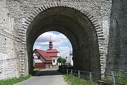 Underpass in Svor | |
 Flag  Coat of arms | |
 Svor Location in the Czech Republic | |
| Coordinates: 50°47′31″N 14°35′49″E / 50.79194°N 14.59694°ECoordinates: 50°47′31″N 14°35′49″E / 50.79194°N 14.59694°E | |
| Country | |
| Region | Liberec |
| District | Česká Lípa |
| First mentioned | 1395 |
| Area | |
| • Total | 18.02 km2 (6.96 sq mi) |
| Elevation | 435 m (1,427 ft) |
| Population (2021-01-01)[1] | |
| • Total | 646 |
| • Density | 36/km2 (93/sq mi) |
| Time zone | UTC+1 (CET) |
| • Summer (DST) | UTC+2 (CEST) |
| Postal code | 471 51 |
| Website | www |

Svor is a municipality and village in Česká Lípa District in the Liberec Region of the Czech Republic. It has about 600 inhabitants.
Administrative parts[]
The village of Rousínov is an administrative part of Svor.
References[]
| show Authority control |
|---|
This Liberec Region location article is a stub. You can help Wikipedia by . |
Categories:
- Populated places in Česká Lípa District
- Villages in Česká Lípa District
- Lusatian Mountains
- Liberec Region geography stubs