Hrusice
Hrusice | |
|---|---|
 Hrusice as seen from east | |
 Flag  Coat of arms | |
| Etymology: Hruša's people | |
 Hrusice Location in the Czech Republic | |
| Coordinates: 49°54′36″N 14°44′17″E / 49.91000°N 14.73806°ECoordinates: 49°54′36″N 14°44′17″E / 49.91000°N 14.73806°E | |
| Country | |
| Region | Central Bohemian |
| District | Prague-East |
| First mentioned | 1205 |
| Government | |
| • Mayor | Petr Sklenář |
| Area | |
| • Total | 5.43 km2 (2.10 sq mi) |
| Elevation | 365 m (1,198 ft) |
| Population (2021-01-01)[1] | |
| • Total | 869 |
| • Density | 160/km2 (410/sq mi) |
| Time zone | UTC+1 (CET) |
| • Summer (DST) | UTC+2 (CEST) |
| Postal code | 251 66 |
| Website | www |

Hrusice (Czech pronunciation: [ˈɦrusɪtsɛ]) is a municipality and village in Prague-East District in the Central Bohemian Region of the Czech Republic. It has about 900 inhabitants. It is located about 30 km (19 mi) southeast of Prague and 11 km (7 mi) southeast of Říčany.
Hrusice is nationwide known as birthplace of Josef Lada and was popularized through his paintings and illustrations on Christmas and Easter postcards and children's books.
Geography[]
The municipality is situated in rolled landscape characteristic for the region southeast of Prague. It borders to municipality of Mnichovice in the north, Ondřejov in the east, Senohraby in the south and Mirošovice in the west.
There are two ponds in the municipal territory, Hrusický in the centre of the village and Hubačovský on the northwest. The Hrusický Stream flows through the municipality, but has only local significance.
The average annual temperature is 7.3 °C and average annual rainfall 620 mm.[citation needed]
History[]
The first written mention of Hrusice is from 1205, in a deed of King Ottokar I of Bohemia. Hrusice belonged to the direct administration of the Přemyslid dynasty. In 1848 the municipality gained self-government.[2]
Demography[]
The municipality has experienced a significant growth in the 21st century thanks to good connection to the capital city.
|
| |||||||||||||||||||||||||||||||||||||||||||||||||||
| Source: Historical lexicon of municipalities of the Czech Republic[3] | ||||||||||||||||||||||||||||||||||||||||||||||||||||
Transport[]
The accessibility of Hrusice is very good due to proximity of two major transport lines. The D1 motorway from Prague to Brno passes through the municipal territory of Hrusice.
There also operates a suburban bus line between Strančice and Stříbrná Skalice (via Mnichovice and Ondřejov) with a stop in the centre of Hrusice.
Sights[]
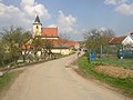
Church of Saint Wenceslaus in the centre of Hrusice is an example of rural Romanesque architecture from the turn of the 12th century with a valuable sandstone portal, a work by monks from Sázava Monastery.[2]
Josef Lada Memorial in artist's villa in southern end of Hrusice, nowadays a branch of Prague-East Regional Museum, presents his life and work as well as his daughter , also a renowned illustrator.
Notable people[]
- Josef Lada (1887–1957), painter, illustrator and writer
Gallery[]
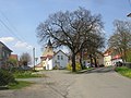
Centre of Hrusice as seen from the south

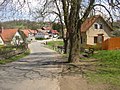
Houses in centre of Hrusice
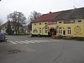
Centre of Hrusice with a bus stop

Municipal office and a small park with bust of Josef Lada
Birthplace of Josef Lada

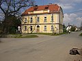
Lada's summer villa, nowadays his museum
U Sejků Pub with murals in style of Lada

Church of St. Wenceslaus

World War I memorial (1921) in front of the church

Romanesque portal made of red sandstone
Rectory opposite to the church
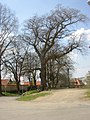
Protected Tilia, planted in 1777


References[]
- ^ "Population of Municipalities – 1 January 2021". Czech Statistical Office. 2021-04-30.
- ^ Jump up to: a b "Historie" (in Czech). Obec Hrusice. Retrieved 2021-06-21.
- ^ "Historický lexikon obcí České republiky 1869–2011 – Okres Praha-východ" (in Czech). Czech Statistical Office. 2015-12-21. pp. 3–4.
External links[]
| Wikimedia Commons has media related to Hrusice. |
- Official website (in Czech)
- Brief tourist info (in English)
| Authority control: National libraries |
|---|
- Populated places in Prague-East District
- Villages in Prague-East District