Konojedy
show This article may be expanded with text translated from the corresponding article in Czech. (July 2009) Click [show] for important translation instructions. |
Konojedy | |
|---|---|
Municipality and village | |
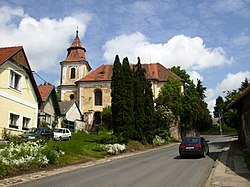 Saint Wenceslaus Church | |
 Flag  Coat of arms | |
 | |
 Konojedy Location in the Czech Republic | |
| Coordinates: 49°57′04″N 14°51′00″E / 49.9511°N 14.85°ECoordinates: 49°57′04″N 14°51′00″E / 49.9511°N 14.85°E | |
| Country | |
| Region | Central Bohemian Region |
| District | Prague-East District |
| Area | |
| • Total | 1.98 sq mi (5.12 km2) |
| Elevation | 1,332 ft (406 m) |
| Population (2010) | |
| • Total | 240 |
| • Density | 120/sq mi (47/km2) |
| Time zone | UTC+1 (CET) |
| • Summer (DST) | UTC+2 (CEST) |

Konojedy is a village and municipality in Prague-East District in the Central Bohemian Region of the Czech Republic.
Notes[]
- This article was initially translated from Czech Wikipedia.
| Wikimedia Commons has media related to Konojedy (Prague-East District). |
| Authority control: National libraries |
|---|
Categories:
- Populated places in Prague-East District
- Villages in Prague-East District
- Prague-East geography stubs