Jenzat
show This article may be expanded with text translated from the corresponding article in French. (December 2008) Click [show] for important translation instructions. |
Jenzat | |
|---|---|
Commune | |
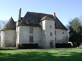 Castle | |
show Location of Jenzat | |
 Jenzat | |
| Coordinates: 46°09′41″N 3°11′45″E / 46.1614°N 3.1958°ECoordinates: 46°09′41″N 3°11′45″E / 46.1614°N 3.1958°E | |
| Country | France |
| Region | Auvergne-Rhône-Alpes |
| Department | Allier |
| Arrondissement | Vichy |
| Canton | Gannat |
| Government | |
| • Mayor (2020–2026) | Claire Mathieu-Portejoie[1] |
| Area 1 | 11.64 km2 (4.49 sq mi) |
| Population (Jan. 2018)[2] | 513 |
| • Density | 44/km2 (110/sq mi) |
| Time zone | UTC+01:00 (CET) |
| • Summer (DST) | UTC+02:00 (CEST) |
| INSEE/Postal code | 03133 /03800 |
| Elevation | 274–449 m (899–1,473 ft) (avg. 315 m or 1,033 ft) |
| 1 French Land Register data, which excludes lakes, ponds, glaciers > 1 km2 (0.386 sq mi or 247 acres) and river estuaries. | |


Jenzat is a commune in the Allier department in central France.
Population[]
| Year | Pop. | ±% |
|---|---|---|
| 1962 | 471 | — |
| 1968 | 492 | +4.5% |
| 1975 | 451 | −8.3% |
| 1982 | 422 | −6.4% |
| 1990 | 439 | +4.0% |
| 1999 | 450 | +2.5% |
| 2008 | 508 | +12.9% |
| 2012 | 527 | +3.7% |
| Source: INSEE (1968–2012) | ||
Neighboring Communities[]
There are six neighboring townships surrounding Jenzat:
- Charroux
- Saint-Bonnet-de-Rochefort
- Mazerier
- Saulzet
- Le Mayet-d'Ecole
- Saint-Germain-de-Salles
See also[]
- Communes of the Allier department
References[]
- ^ "Répertoire national des élus: les maires". data.gouv.fr, Plateforme ouverte des données publiques françaises (in French). 2 December 2020. Retrieved 7 December 2020.
- ^ "Populations légales 2018". INSEE. 28 December 2020.
| Wikimedia Commons has media related to Jenzat. |
| show Communes of the Allier department |
|---|
| Authority control |
|---|
This Allier geographical article is a stub. You can help Wikipedia by . |
Categories:
- Communes of Allier
- Allier geography stubs