Kafir-kala (Uzbekistan)


Coordinates: 39°34′19″N 67°01′17″E / 39.572013°N 67.021506°E

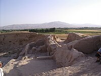
Kafir-kala ("Fortress of the infidels") is an ancient fortress 12 kilometers south of the city center of Samarkand in Uzbekistan, protecting the southern border of the Samarkand oasis.[2] It consists in a central citadel built in mud-bricks and measuring 75 × 75 meters at its base has six towers and is surrounded by a moat, still visible today.[2] Living quarters were located outside the citadel.[2]
The citadel was first occupied by the Kidarites in the 4th-5th century CE, whose coinage and bullae have been found.[3][4]
Many examples of coinage were excavated in Kafir-kala, which also show the transition from Sogdian to Islamic rule in the area of Samarkand with good precision.[5]

Ruins of Kafir Kala
Ruins of Kafir Kala


External links[]
References[]
- ^ "Antiquities of Samarkand. Kurgan in the Vicinity of Samarkand. Location of Kafir Kala". www.wdl.org. 1868.
- ^ Jump up to: a b c Mantellini, Simone (2012). "Change and Continuity in the Samarkand Oasis: Evidence for the Islamic Conquest from the Citadel of Kafir Kala". Journal of Inner Asian Art and Archaeology. 7: 227–253.
- ^ "Administration, law and urban organization in the Late Antique and Early Medieval period". Universitetet i Bergen (in Norwegian Bokmål).
- ^ "The Kidarites in Bactria". pro.geo.univie.ac.at. Coin Cabinet of the Kunsthistorisches Museum Vienna.
- ^ Gariboldi, Andrea. "NUMISMATIC FINDS FROM KAFIR KALA AS EVIDENCE OF THE ISLAMIC TRANSITION IN SAMARKAND" (PDF). Cite journal requires
|journal=(help)
Further reading[]
- Mantellini, Simone; Berdimuradov, Amruddin (2005). "Archaeological Explorations in the Sogdian Fortress of Kafir Kala (Samarkand Region, Republic of Uzbekistan)". Ancient Civilizations from Scythia to Siberia. 11 (1–2): 107–132. doi:10.1163/1570057054352934.
- Populated places in Samarqand Region
- Populated places along the Silk Road
- Cities in Central Asia
- Sogdian cities
- Archaeological sites in Uzbekistan