Kenhorst, Pennsylvania
Kenhorst, Pennsylvania | |
|---|---|
Borough | |
 New Holland Rd., Kenhorst. | |
 Location of Kenhorst in Berks County, Pennsylvania. | |
 Kenhorst Location of Kenhorst in Pennsylvania | |
| Coordinates: 40°18′29″N 75°56′39″W / 40.30806°N 75.94417°WCoordinates: 40°18′29″N 75°56′39″W / 40.30806°N 75.94417°W | |
| Country | United States |
| State | Pennsylvania |
| County | Berks |
| Founded | August 25, 1931 |
| Government | |
| • Mayor | Nickolas J. Hatzas |
| Area | |
| • Total | 0.59 sq mi (1.52 km2) |
| • Land | 0.59 sq mi (1.52 km2) |
| • Water | 0.00 sq mi (0.00 km2) |
| Elevation | 344 ft (105 m) |
| Population (2010) | |
| • Total | 2,877 |
| • Estimate (2019)[2] | 2,805 |
| • Density | 4,786.69/sq mi (1,847.77/km2) |
| Time zone | UTC-5 (EST) |
| • Summer (DST) | UTC-4 (EDT) |
| ZIP code | 19607 |
| Area code(s) | 610 and 484 |
| FIPS code | 42-39256 |
| Website | www |


Kenhorst (/ˈkɛnhərst/ KEN-hərst) is a borough in Berks County, Pennsylvania, United States. The population was 2,877 at the 2010 census.[3]
Geography[]
Kenhorst is located in central Berks County at 40°18′29″N 75°56′39″W / 40.30806°N 75.94417°W (40.308092, -75.944042).[4] It is bordered by the city of Reading to the north and east and by Cumru Township to the south and west, including the census-designated place of Grill to the southeast.
According to the United States Census Bureau, the borough has a total area of 0.58 square miles (1.5 km2), all of it land.[3]
Demographics[]
| Historical population | |||
|---|---|---|---|
| Census | Pop. | %± | |
| 1940 | 2,227 | — | |
| 1950 | 2,551 | 14.5% | |
| 1960 | 2,815 | 10.3% | |
| 1970 | 3,482 | 23.7% | |
| 1980 | 3,187 | −8.5% | |
| 1990 | 2,918 | −8.4% | |
| 2000 | 2,679 | −8.2% | |
| 2010 | 2,877 | 7.4% | |
| 2019 (est.) | 2,805 | [2] | −2.5% |
| Sources:[5][6][7] | |||
As of the census[6] of 2000, there were 2,679 people, 1,215 households, and 789 families living in the borough. The population density was 4,551.8 people per square mile (1,753.2/km2). There were 1,254 housing units at an average density of 2,130.6 per square mile (820.6/km2). The racial makeup of the borough was 95.86% White, 0.82% African American, 0.04% Native American, 1.61% Asian, 1.05% from other races, and 0.63% from two or more races. Hispanic or Latino of any race were 2.02% of the population.
There were 1,215 households, out of which 22.2% had children under the age of 18 living with them, 53.9% were married couples living together, 8.4% had a female householder with no husband present, and 35.0% were non-families. 30.0% of all households were made up of individuals, and 14.0% had someone living alone who was 65 years of age or older. The average household size was 2.20 and the average family size was 2.72.
In the borough the population was spread out, with 18.4% under the age of 18, 4.3% from 18 to 24, 29.9% from 25 to 44, 22.8% from 45 to 64, and 24.6% who were 65 years of age or older. The median age was 43 years. For every 100 females there were 93.7 males. For every 100 females age 18 and over, there were 91.2 males.
The median income for a household in the borough was $40,452, and the median income for a family was $44,762. Males had a median income of $37,243 versus $27,162 for females. The per capita income for the borough was $21,379. About 6.1% of families and 7.9% of the population were below the poverty line, including 12.0% of those under age 18 and 14.1% of those age 65 or over.
Gallery[]

War Memorial in Kenhorst.

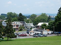
New Holland Rd.

Lacrosse Ave.

St. Stephen's Memorial Cemetery.
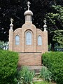
St. Nicolas Chapel at Memorial Cemetery.


References[]
- ^ "2019 U.S. Gazetteer Files". United States Census Bureau. Retrieved July 28, 2020.
- ^ Jump up to: a b "Population and Housing Unit Estimates". United States Census Bureau. May 24, 2020. Retrieved May 27, 2020.
- ^ Jump up to: a b "Geographic Identifiers: 2010 Demographic Profile Data (G001): Kenhorst borough, Pennsylvania". U.S. Census Bureau, American Factfinder. Archived from the original on February 12, 2020. Retrieved March 6, 2014.
- ^ "US Gazetteer files: 2010, 2000, and 1990". United States Census Bureau. 2011-02-12. Retrieved 2011-04-23.
- ^ "Census of Population and Housing". U.S. Census Bureau. Retrieved 11 December 2013.
- ^ Jump up to: a b "U.S. Census website". United States Census Bureau. Retrieved 2008-01-31.
- ^ "Incorporated Places and Minor Civil Divisions Datasets: Subcounty Resident Population Estimates: April 1, 2010 to July 1, 2012". Population Estimates. U.S. Census Bureau. Archived from the original on 11 June 2013. Retrieved 11 December 2013.
External links[]
| Wikimedia Commons has media related to Kenhorst, Pennsylvania. |
| show Municipalities and communities of Berks County, Pennsylvania, United States |
|---|

| show Authority control |
|---|
- Populated places established in 1931
- Boroughs in Berks County, Pennsylvania
- 1931 establishments in Pennsylvania