Kushiro
Kushiro
釧路市 | |||||||||||
|---|---|---|---|---|---|---|---|---|---|---|---|
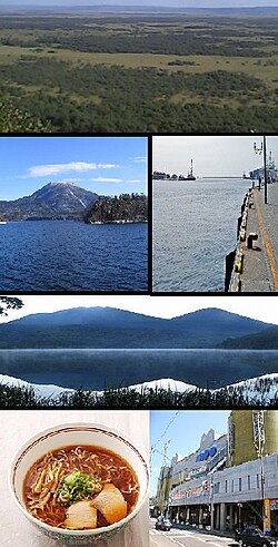 Top:Kushiro Wetland Park, 2nd left:Lake Akan, 2nd right Port of Kushiro, 3rd: Mount Akan-Fuji, Bottom left:Kushiro Ramen, Bottom right:Kushiro Fisherman's Wharf | |||||||||||
 Flag  Emblem | |||||||||||
 Location of Kushiro in Hokkaido (Kushiro Subprefecture) | |||||||||||
 Kushiro Location in Japan | |||||||||||
| Coordinates: 42°59′N 144°23′E / 42.983°N 144.383°ECoordinates: 42°59′N 144°23′E / 42.983°N 144.383°E | |||||||||||
| Country | Japan | ||||||||||
| Region | Hokkaido | ||||||||||
| Prefecture | Hokkaido (Kushiro Subprefecture) | ||||||||||
| Government | |||||||||||
| • Mayor | Ebina Hiroya | ||||||||||
| Area | |||||||||||
| • Total | 1,362.75 km2 (526.16 sq mi) | ||||||||||
| Population (January 31, 2020) | |||||||||||
| • Total | 167,875 | ||||||||||
| • Density | 123/km2 (320/sq mi) | ||||||||||
| Time zone | UTC+09:00 (JST) | ||||||||||
| City hall address | 7-5 Kuroganechō, Kushiro-shi, Hokkaido 085-8505 | ||||||||||
| Website | www | ||||||||||
| |||||||||||

Kushiro (釧路市, Kushiro-shi) is a city in Kushiro Subprefecture on the island of Hokkaido, Japan. It serves as the subprefecture's capital and it is the most populated city in the eastern part of the island.
History[]
An Imperial decree in July 1899 established Kushiro as an open port for trading with the United States and the United Kingdom.[1]
Kushiro has been an important port because it is more reliably ice-free during winter than alternative Russian Far East warm-water ports such as Petropavlovsk-Kamchatsky or other ports in Hokkaido such as Hakodate, which occasionally do freeze for short periods due to the lower salinity of the Sea of Japan. For this reason, Kushiro was considered a valuable target for the Tsars during the Russo-Japanese Wars, but it only became a really important port during the 1920s with the growth of commercial fishing, for which its reliable freedom from ice reduced costs.[2]
In addition to its port, Kushiro is serviced by Kushiro Airport with flights from Honshu and by the Super Ōzora limited express train service, which runs seven times per day to the main population centres in the west of Hokkaido.
Following the Invasion of the Kuril Islands in August 1945, Kushiro was favoured by the Russians as the eastern cornerstone of a border between an American-occupied south and a Soviet-occupied north-coupled with Rumoi as the western cornerstone. However, these plans were cancelled after pressure by US President Harry S. Truman.[3][4][5][6]
On October 11, 2005, the town of Akan, from Akan District, and the town of Onbetsu, from Shiranuka District, was merged into Kushiro. The town of Shiranuka now lies between the two sections of Kushiro.
In 2008, the city had an estimated population of 189,539 and a total area of 1,362.75 km2 (526.16 sq mi), giving a population density of 140 persons per km2 (363 persons per sq. mi.).
Kushiro was one of the many Japanese cities to receive a Peace Pagoda. Built by the monks and nuns of the Buddhist order Nipponzan Myohoji, it was inaugurated in 1959.
Kushiro was accorded city status on 1 August 1922. It is the sister city of Burnaby, British Columbia; Petropavlovsk-Kamchatsky, Russia; and Kholmsk, Russia.[7]
- 1869: Kusuri becomes Kushiro.
- 1900: Kushiro becomes a First Class Municipality as Kushiro Town.
- 1920: Kushiro Town becomes Kushiro-ku. Kushiro Village (now Town) splits off.
- 1922: Kushiro-ku becomes Kushiro City.
- 2005: The old city of Kushiro City, Akan Town, and Onbetsu Town merged was expanded city of Kushiro City.
Geography[]


Mountains[]
- Mount Oakan
- Mount Meakan
- Mount Akan-Fuji
Rivers[]
- Kushiro River
- Akan River
- Shitakara River
Lakes[]
- Lake Akan
- Lake Harutori
- Lake Panketō
- Lake Penketō
- Lake Shunkushitakara
National Parks[]
- Kushiro-shitsugen National Park
- Akan National Park
Climate[]
Kushiro has a humid continental climate (Dfb) but its winter temperatures are less severe than those of inland East Asia at the same latitude. Its port is the most reliably ice-free throughout winter in all of Hokkaido, due to the lack of indentation in the coastline and absence of large inflows of cold fresh water nearby. It is also markedly sunnier than the extremely gloomy Kuril Islands to its north, being sheltered by Hokkaido's mountains from the heavy snowfalls produced on the Sea of Japan side by the Aleutian Low. It receives only a third as much snowfall as Sapporo and almost twice as much sunshine as the Kuril Islands are estimated to.
| hideClimate data for Kushiro (1991−2020 normals, extremes 1910−present) | |||||||||||||
|---|---|---|---|---|---|---|---|---|---|---|---|---|---|
| Month | Jan | Feb | Mar | Apr | May | Jun | Jul | Aug | Sep | Oct | Nov | Dec | Year |
| Record high °C (°F) | 7.6 (45.7) |
7.9 (46.2) |
15.9 (60.6) |
23.5 (74.3) |
28.0 (82.4) |
32.4 (90.3) |
31.4 (88.5) |
31.1 (88.0) |
29.6 (85.3) |
22.9 (73.2) |
18.7 (65.7) |
12.4 (54.3) |
32.4 (90.3) |
| Average high °C (°F) | −0.2 (31.6) |
−0.1 (31.8) |
3.3 (37.9) |
8.0 (46.4) |
12.6 (54.7) |
15.8 (60.4) |
19.6 (67.3) |
21.5 (70.7) |
20.1 (68.2) |
15.1 (59.2) |
8.9 (48.0) |
2.5 (36.5) |
10.6 (51.1) |
| Daily mean °C (°F) | −4.8 (23.4) |
−4.3 (24.3) |
−0.4 (31.3) |
4.0 (39.2) |
8.6 (47.5) |
12.2 (54.0) |
16.1 (61.0) |
18.2 (64.8) |
16.5 (61.7) |
11.0 (51.8) |
4.7 (40.5) |
−1.9 (28.6) |
6.7 (44.1) |
| Average low °C (°F) | −9.8 (14.4) |
−9.4 (15.1) |
−4.2 (24.4) |
0.7 (33.3) |
5.4 (41.7) |
9.5 (49.1) |
13.6 (56.5) |
15.7 (60.3) |
12.9 (55.2) |
6.1 (43.0) |
−0.3 (31.5) |
−7.0 (19.4) |
2.8 (37.0) |
| Record low °C (°F) | −28.3 (−18.9) |
−27.0 (−16.6) |
−24.8 (−12.6) |
−14.1 (6.6) |
−4.6 (23.7) |
−0.4 (31.3) |
3.3 (37.9) |
5.4 (41.7) |
−2.2 (28.0) |
−6.9 (19.6) |
−15.2 (4.6) |
−25.7 (−14.3) |
−28.3 (−18.9) |
| Average precipitation mm (inches) | 40.4 (1.59) |
24.8 (0.98) |
55.9 (2.20) |
79.4 (3.13) |
115.7 (4.56) |
114.2 (4.50) |
120.3 (4.74) |
142.3 (5.60) |
153.0 (6.02) |
112.7 (4.44) |
64.7 (2.55) |
56.6 (2.23) |
1,080.1 (42.52) |
| Average snowfall cm (inches) | 32 (13) |
27 (11) |
31 (12) |
7 (2.8) |
0 (0) |
0 (0) |
0 (0) |
0 (0) |
0 (0) |
0 (0) |
4 (1.6) |
26 (10) |
127 (50) |
| Average precipitation days (≥ 0.5 mm) | 6.4 | 5.6 | 8.1 | 9.8 | 11.3 | 10.2 | 11.5 | 11.8 | 11.8 | 8.7 | 8.0 | 7.7 | 110.8 |
| Average relative humidity (%) | 67 | 69 | 71 | 77 | 80 | 87 | 88 | 87 | 84 | 76 | 69 | 67 | 77 |
| Mean monthly sunshine hours | 186.7 | 183.1 | 200.8 | 182.2 | 177.5 | 126.8 | 118.9 | 117.6 | 143.9 | 177.0 | 167.6 | 175.6 | 1,957.6 |
| Source: Japan Meteorological Agency[8] | |||||||||||||
Education[]
Universities[]
National[]
- Hokkaido University of Education, Kushiro Campus
Public[]
- Kushiro Public University of Economics
Colleges[]
National[]
- Kushiro National College of Technology
Private[]
- Kushiro junior College
High schools[]
Public[]
- Hokkaido Kushiro Koryo High School
- Hokkaido Kushiro Konan High School
- Hokkaido Kushiro Meiki High School
- Hokkaido Kushiro Commercial High School
- Hokkaido Kushiro Technical High School
- Hokkaido Akan High School
- Hokkaido Kushiro Hokuyo High School
Private[]
- Bushukan High School
- Ikegami Gakuen High School, Kushiro Campus
Transportation[]
- Kushiro Airport
- Port of Kushiro
- JR Hokkaido
- Nemuro Main Line : Chokubetsu - Shakubetsu Station - Onbetsu - (Shiranuka, Hokkaido) - Otanoshike - Shin-Otanoshike - Shin-Fuji - Kushiro - Higashi-Kushiro - Musa
- Senmō Main Line : Higashi-Kushiro
- Taiheiyō Coal Services and Transportation Rinkō Line
Sports[]
Ice hockey is one of the most popular winter sports in Kushiro. In addition to several leagues devoted to amateur play of all ages, Kushiro is home to the Asia League Ice Hockey Nippon Paper Cranes, three time Asia League Champions.
Kushiro and many other cities are interested in hosting bandy teams.[9] On January 8, 2017, the township of Akan hosted the first national championship,[10] although the size of the field was a smaller version than the official rules for a bandy field. In January 2018, the first championship on a full-sized field took place in Shintoku, with participation from three teams, including FACEOFF Kushiro.[11] The national team for women is based in Kushiro and will make its World Championship debut in 2020.[12]
Notable people[]
- Akira Ifukube composer
- Kazuhiko Chiba football player
- Yutaka Fukufuji ice hockey goaltender
- Yukinobu Hoshino manga artist
- Keisuke Itagaki manga artist
- Saori Kitakaze sprinter
- Satoshi Kon anime film director
- Luna H. Mitani artist
- Hiromi Nagakura photographer
- Maki Nomiya singer of the Japanese band "Pizzicato Five"
- Shinji Somai film director
- Kazuro Watanabe astronomer
- Aina Takeuchi ice hockey defenseman with Calgary Inferno
Sister cities[]
 Yuzawa, Akita, Japan (since 1963)
- Tottori, Tottori, Japan (since 1963)
 Burnaby, British Columbia, Canada (since 1965)
 Kholmsk, Kholmsky District, Sakhalin Oblast, Russia (since 1975)
- Petropavlovsk-Kamchatsky, Kamchatka Krai, Russia (since 1998)
 Port Stephens, New South Wales, Australia (since 1994)[13]
References[]
- ^ US Department of State. (1906). A digest of international law as embodied in diplomatic discussions, treaties and other international agreements (John Bassett Moore, ed.), Vol. 5, p. 759.
- ^ Port of Kushiro
- ^ Holloway, David, ‘Jockeying for Position in the Postwar World: Soviet Entry into the War with Japan in August 1945’, in The End of the Pacific War: Reappraisals, ed. by Tsuyoshi Hasegawa (Stanford: Stanford University Press, 2007), pp. 145-188 (pp. 178-179).
- ^ Nimmo, William F (2001). Stars and Stripes Across the Pacific: The United States, Japan, and Asia page 237. ISBN 9780275964535. Retrieved December 18, 2017.
- ^ Clark, Gregory (August 22, 2014). "How WWII could have ended". Japan Times. Retrieved December 18, 2017.
- ^ Yumashev, Ivan (August 19, 1945). "REPORT BY IVAN YUMASHEV TO ALEKSANDR VASILEVSKY". Retrieved December 18, 2017.
- ^ Russian presence in Japan Archived August 21, 2011, at WebCite
- ^ 気象庁 / 平年値(年・月ごとの値). Japan Meteorological Agency. Retrieved May 19, 2021.
- ^ Greetings from Yukiaki Okada President Japan Bandy Federation
- ^ [1]
- ^ [2]
- ^ [3]
- ^ "Port Stephens Council: Port Stephens Sister Cities". 2007-09-27. Archived from the original on 2007-09-27. Retrieved 2018-01-17.
External links[]
| Wikimedia Commons has media related to Kushiro. |
 Kushiro travel guide from Wikivoyage
- Official Website (in Japanese)
| show |
|---|
| show Authority control |
|---|
- Kushiro, Hokkaido
- Cities in Hokkaido
- Port settlements in Japan
- Populated coastal places in Japan