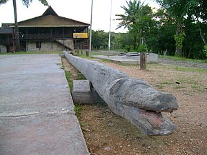
La Chorrera, Colombia
This article includes a list of references, related reading or external links, but its sources remain unclear because it lacks inline citations. (March 2010) |
La Chorrera | |
|---|---|
Municipality and town | |
 | |
 Location of the municipality and town of La Chorrera in the Amazonas Department of Colombia | |
 La Chorrera Location in Colombia | |
| Coordinates: 1°26′49″S 72°47′40″W / 1.44694°S 72.79444°WCoordinates: 1°26′49″S 72°47′40″W / 1.44694°S 72.79444°W | |
| Country | |
| Department | |
| Area | |
| • Total | 12,670 km2 (4,890 sq mi) |
| Climate | Af |
La Chorrera is a town and municipality in the southern Colombian Department of Amazonas.[1] The population is largely engaged in agricultural production, hunting, fishing, and banana and cassava growing. The municipality was once a notable site for rubber production, exploited by the Peruvian Julio César Arana brothers at the turn of the 20th century, north of the Putumayo River. The territory has an area of 12670 km².
References[]
- ^ García, Uriel Gonzalo Murcia; García, Claudia Milena Huertas; Rondón, Juan Manuel Rodríguez; Castellanos, Henry Omar Augusto (2011-12-14). Monitoreo de los bosques y otras coberturas de la Amazonia Colombiana, a escala 1:100.000 Cambios multitemporales en el período 2002 al 2007 (in Spanish). Instituto Amazónico de Investigaciones Científicas "SINCHI". ISBN 978-958-8317-70-0.
External links[]
- (in Spanish) Government of Amazonas Department; La Chorrera
Categories:
- Municipalities of Amazonas Department
- Amazonia Region (Colombia) geography stubs
