Le Donjon
show This article may be expanded with text translated from the corresponding article in French. (December 2008) Click [show] for important translation instructions. |
Le Donjon | |
|---|---|
Commune | |
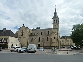 The church in Le Donjon | |
 Coat of arms | |
show Location of Le Donjon | |
 Le Donjon | |
| Coordinates: 46°21′05″N 3°47′37″E / 46.3514°N 3.7936°ECoordinates: 46°21′05″N 3°47′37″E / 46.3514°N 3.7936°E | |
| Country | France |
| Region | Auvergne-Rhône-Alpes |
| Department | Allier |
| Arrondissement | Vichy |
| Canton | Dompierre-sur-Besbre |
| Government | |
| • Mayor (2020–2026) | Guy Labbe[1] |
| Area 1 | 37.02 km2 (14.29 sq mi) |
| Population (Jan. 2018)[2] | 1,068 |
| • Density | 29/km2 (75/sq mi) |
| Time zone | UTC+01:00 (CET) |
| • Summer (DST) | UTC+02:00 (CEST) |
| INSEE/Postal code | 03103 /03130 |
| Elevation | 265–466 m (869–1,529 ft) (avg. 292 m or 958 ft) |
| 1 French Land Register data, which excludes lakes, ponds, glaciers > 1 km2 (0.386 sq mi or 247 acres) and river estuaries. | |


Le Donjon is a commune in the Allier department in central France.
Population[]
| Year | Pop. | ±% |
|---|---|---|
| 1962 | 1,502 | — |
| 1968 | 1,512 | +0.7% |
| 1975 | 1,447 | −4.3% |
| 1982 | 1,366 | −5.6% |
| 1990 | 1,258 | −7.9% |
| 1999 | 1,168 | −7.2% |
| 2008 | 1,067 | −8.6% |
| 2012 | 1,084 | +1.6% |
See also[]
- Communes of the Allier department
References[]
- ^ "Répertoire national des élus: les maires". data.gouv.fr, Plateforme ouverte des données publiques françaises (in French). 2 December 2020. Retrieved 7 December 2020.
- ^ "Populations légales 2018". INSEE. 28 December 2020.
| Wikimedia Commons has media related to Le Donjon. |
| show Communes of the Allier department |
|---|
| show Authority control |
|---|
This Allier geographical article is a stub. You can help Wikipedia by . |
Categories:
- Communes of Allier
- Allier geography stubs