The Leo Belgicus (Latin for Belgic Lion) was used in both heraldry and map design to symbolize the former Low Countries (current day Netherlands, Luxembourg, Belgium and a small part of northern France) with the shape of a lion.
The names derived from the Belgae (and thus including Belgica) are now mostly identified with the country Belgium; yet before the division of the Low Countries into a southern and a northern half in the 16th century, it was a common name for the entire Low Countries, and was the usual Latin translation of the Netherlands (which at that point covered the current territory of the Netherlands, Luxembourg, Belgium and a small part of northern France). Several somewhat later maps of the Dutch Republic, which consisted of the Northern Netherlands, and therefore has almost no intersection with the present country of Belgium, also show the Latin title Belgium Foederatum.[1] Also, a 17th-century colonial province that was located on the East Coast of North America — which was ruled and settled exclusively by the Dutch Republic and in which the present Belgium had no share — was known in Dutch as Nieuw-Nederland but in Latin as Nova Belgica or Novum Belgium.
History[]
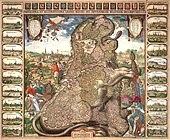
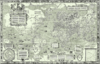
The earliest Leo Belgicus was drawn by the AustriancartographerMichaël Eytzinger in 1583, when the Netherlands were fighting the Eighty Years' War for independence. The motif was inspired by the heraldic figure of the lion, occurring in the coats of arms of several of the Netherlands, namely: Brabant, Flanders, Frisia, Guelders, Hainaut, Holland, Limburg, Luxembourg, Namur and Zeeland, as well as in those of William of Orange.
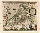
Eytzinger's map was the first of many. There were three different designs. In the most common one, the lion's head was located in the northeast of the country and the tail in the southeast. The most famous version is that of Claes Janszoon Visscher, which was published in 1609 on the occasion of the Twelve Years' Truce. A less common design reversed the position of the lion, as shown in the Leo Belgicus by Jodocus Hondius.
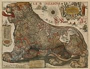
The third version was published in the later stages of the war, and after the independence of the Dutch Republic was confirmed in the Peace of Westphalia (1648). It is called the Leo Hollandicus, the Holland Lion, and shows only the province of Holland. One of the earliest versions was published by Visscher around 1625.
A Dutch coin of 1753 depicting the Leo Belgicus holding a liberty pole
Patriotic scene on a engraved glass with the Batavian Lion, Cap of Liberty, and putto with a cornucopia, inscribed "The Batavian Commonwealth", c. 1765, stipple engraving by David Wolff.
Symbol of the Batavian Republic, 1795-1806; the Dutch Maiden and Leo Belgicus.
‹ The template below (Early modern Netherlandish cartography, geography and cosmography) is being considered for deletion. See templates for discussion to help reach a consensus. ›
History of geography (First undisputed non-Indigenous discovery, exploration and mapping of Australasia, including the Australian continent and New Zealand, excluding New Guinea, 1606–1646)
History of geodesy and surveying (First published systematic uses of the triangulation method in modern surveying and mapmaking, 1533–1615)
Note: 1 Depictions of early modern Netherlandish cartography, geography and cosmography (especially in the Golden Age of Netherlandish cartography, approximately 1570s–1670s) in works of art