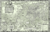
Caert van't Landt van d'Eendracht ("Chart of the Land of Eendracht") is a 1627 map by Hessel Gerritsz. One of the earliest maps of Australia, it shows what little was then known of the west coast, based on a number of voyages beginning with the 1616 voyage of Dirk Hartog, when he named Eendrachtsland after his ship.
Ashburton River is almost exactly at the latitude at which Hessel Gerritsz’ chart shows Willem River.
The map is oriented with north to the left and shows lines of latitude from 20th parallel south to the 35th parallel south and also shows the Tropic of Capricorn. The top left of the map shows a river labelled Willems revier, besocht by 't volck van 't Schip Mauritius in Iulius A° 1618 ("Willem's River, visited by the crew of the ship Mauritius in July 1618"). The identity of this river, now referred to as Willem River, is unknown; it is possibly the Ashburton River.[1]
In the bottom left corner is a feature labelled Hier ist Engels schip de Trial vergaen in Iunias, A° 1622 ("Here the English ship Trial was wrecked in June 1622"). This is possibly the first appearance on a map of the Tryal Rocks, the identity of which was not determined until the 1960s.[citation needed]
Other than these two features, the leftmost third of the map shows a fairly straight, featureless coastline, set in between the 21st parallel south and the 26th parallel south, labelled 'T Landt van de Eendracht, opghedaen by Dirck Hartogs met 't Schip d'Eendracht in October A° 1616 ("The Land of Eendracht", discovered by Dirk Hartog of the Eendracht in October 1616"). The way this is written on the map in such bold figures implies that the Dutch were naming the entire country (land). Right on the 26th parallel south latitude is written "Dirk Hartog rec" showing what is now known as Dirk Hartog Island, as part of mainland Western Australia.
The middle third of the map has two main features. One, labelled Fr. Houtman's abrolhos, shows the archipelago discovered by Frederick de Houtman in 1619, and now known as the Houtman Abrolhos. Although this map was not the first to show the Houtman Abrolhos, it represents the earliest known publication of the name.
The other feature, labelled Tortelduyff ("Turtledove"), lies slightly to the south (that is, to the right) of the Houtman Abrolhos. Now known as Turtle Dove Shoal, the name is thought to signify that the shoal was first discovered by the ship Tortelduif, which is recorded as having arrived at Batavia, Dutch East Indies on 21 June 1623.[2] Gerritsz's 1627 Caert is the earliest known map to show this feature.
The rightmost third of the map shows a section of coastline labelled 't Landt van de Leeuwin beseylt A° 1622 in Maert. ("Land made by the ship Leeuwin in March 1622.") This is thought to represent the coast between present-day Hamelin Bay and .[3] Portions of this coastline are labelled Duynich landt boven met boomen ende boseage ("Dunes with trees and forest"), Laegh ghelijck verdroncken landt ("Low land like flood liable land") and Laegh duynich landt ("Low land with dunes"). This section of coastline is significant because the Leeuwin's log book is lost, and very little is known of this ship's voyage, other than what is revealed by this map.
^Tent, Jan (March 2006). "The importance of bygone placenames". Placenames Australia: Newsletter of the Australian National Placenames Survey: 10–11.
^Heeres, Jan Ernst (1899). The part borne by the Dutch in the discovery of Australia 1606-1765 (Project Gutenberg of Australia edition ed.). London: Luzac & co.
^"Voyages - 1622 - Leeuwin". South Land to New Holland : Dutch chartin of Australia 1606–1756. National Library of Australia. Retrieved 30 January 2008.
History of geography (First undisputed non-Indigenous discovery, exploration and mapping of Australasia, including the Australian continent and New Zealand, excluding New Guinea, 1606–1646)
History of geodesy and surveying (First published systematic uses of the triangulation method in modern surveying and mapmaking, 1533–1615)
Note: 1 Depictions of early modern Netherlandish cartography, geography and cosmography (especially in the Golden Age of Netherlandish cartography, approximately 1570s–1670s) in works of art
Categories:
1627 works
Exploration of Western Australia
Historic maps of Oceania
Maps of Australia
Shark Bay
Works of the Dutch Golden Age
Cartography in the Dutch Republic
17th-century maps and globes
Hidden categories:
Articles with short description
Short description is different from Wikidata
Use Australian English from March 2018
All Wikipedia articles written in Australian English
Use dmy dates from March 2018
All articles with unsourced statements
Articles with unsourced statements from January 2012