This article
relies largely or entirely on a single source .
Relevant discussion may be found on the talk page . Please help by introducing citations to additional sources .Find sources: – · · · scholar · JSTOR (January 2020 )
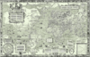
Novaya Zemlya 's west coast as depicted in De Veer's diary
Gerrit de Veer (c. 1570 –c. 1598 ) was a Dutch officer on Willem Barentsz ' second and third voyages of 1595 and 1596 respectively, in search of the Northeast passage .
De Veer kept a diary of the voyages and in 1597, was the first person to observe and record the Novaya Zemlya effect , and the first Westerner to observe hypervitaminosis A caused by consumption of the liver of a polar bear.[1] [incomplete short citation
References [ ] People
Cornelis Anthonisz. Theodor de Bry Franciscus Monachus Gemma Frisius Gaspard van der Heyden Gerard Mercator Rumold Mercator Abraham Ortelius Christophe Plantin Pieter van den Keere Lucas Waghenaer Jan Huyghen van Linschoten Adriaen van der Donck Petrus Bertius Pieter Bast Willem Barentsz Gerrit de Veer Adriaen Block Pieter de Marees Andries Beeckman Dirk Valkenburg Albert Eckhout Frans Post Willem Piso Hendrik Brouwer Dirk Hartog Jacob Le Maire Jacques l'Hermite Willem Schouten Willem Janszoon Jan Carstenszoon Hendrik van Rheede Jan van Riebeeck Simon van der Stel Abel Tasman Isaack Gilsemans Maarten Gerritsz Vries Willem de Vlamingh Robert Jacob Gordon Jacob Roggeveen Jacob van Deventer Pieter Dirkszoon Keyser Johannes van Keulen Frederick de Houtman Christiaan Huygens Willebrord Snel van Royen Hessel Gerritsz Abraham Goos Pieter Goos Petrus Plancius Joris Hoefnagel Frans Hogenberg Jodocus Hondius Henricus Hondius II Hendrik Hondius I Willem Blaeu Johannes Blaeu Johannes Janssonius Andreas Cellarius Gerard de Jode Cornelis de Jode Michiel van Langren Jacob Floris van Langren Pieter van der Aa Anton van den Wyngaerde Johan Nieuhof Isaac Titsingh Pieter Nuyts Frans Thijssen Adriaan Reland Johannes Ruysch François Valentijn Johannes Vermeer Claes Visscher Nicolaes Visscher I Nicolaes Visscher II Frederik de Wit Cornelis van Wytfliet Notable works
Itinerario Historia Naturalis Brasiliae An embassy from the East-India Company of the United Provinces Illustrations of Japan Oud en Nieuw Oost-Indiën Leo Belgicus Mercator's 1569 World Map Atlas Cosmographicae Theatrum Orbis Terrarum Theatre of the Orb of the World , 1570)Maris Pacifici Speculum Orbis Terrarum Mercator-Hondius Atlas Atlas Blaeu-Van der Hem Atlas Maior Atlas van Loon Spieghel der Zeevaerdt Mariner's Mirror )Atlas de Wit Atlas Minor Atlas Novus Beudeker Collection Blaeu Atlas of Scotland Caert van't Landt van d'Eendracht Klencke Atlas Speculum Orbis Terrae Civitates Orbis Terrarum Tasman Map (c. 1644)Plenilunii Lumina Austriaca Philippica Van Langren's map of the Moon , 1645)Harmonia Macrocosmica Dutch-created constellations (include: Apus , Camelopardalis , Chamaeleon , Cancer Minor , Columba , Crux , Dorado , Gallus , Grus , Hydrus , Indus , Jordanus , Monoceros , Musca / Apis , Musca Borealis / Apes , Phoenix , Tigris , Triangulum Australe , Tucana , Volans ) Main centres General
Dutch school of cartography Flemish cartography Golden Age of Dutch cartography / Golden Age of Netherlandish cartography (c. 1570s–1670s)Netherlandish school of cartography Cartography in the Dutch Republic Astronomy in the Dutch Republic Dutch celestial cartography in the Age of Discovery (history of surveying and creation of maps of the Netherlands )
Cartography of Belgium (history of surveying and creation of maps of Belgium )
Cartography of the Low Countries (history of surveying and creation of maps of the Low Countries )
Dutch celestial and lunar cartography in the Age of Exploration (Dutch systematic mapping of the far southern sky, c. 1595–1599 )Dutch commercial cartography in the Age of Discovery Dutch corporate cartography in the Age of Discovery Dutch maritime/nautical cartography in the Age of Discovery Golden Age of Dutch exploration and discovery (c. 1590s–1720s)Constellations created and listed by Dutch celestial cartographers Triangulation (surveying) Waggoner (nautical) Mercator projection Atlas Continental drift (hypothesis/theory)Method of determining longitude at sea by means of timekeepers/chronometers Optical telescope (invention and history of the telescope )Modern use of the term 'landscape/landschap ' (etymology )
Renaissance cartography
Baroque cartography Related
Search for the Northeast Passage
Search for the Northwest Passage
Dutch discovery, exploration and mapping of Svalbard (cartography of Svalbard /Spitsbergen )Dutch discovery, exploration and mapping of Jan Mayen (cartography of Jan Mayen )European exploration and mapping of Southern Africa Search for the Great Southern Land/Great Unknown South Land (Terra Australis Nondum Cognita /Terra Australis Incognita )
European maritime exploration of Australia (Janszoon voyage of 1605–06 , Brouwer Route , Hartog's Plate , Eendrachtsland , Anthoonij van Diemens Landt , Nova Hollandia/Nieuw Holland )European land exploration of Australia Dutch discovery, exploration and mapping of Australasia (cartography of Australasia )Dutch discovery, exploration and mapping of Nova Hollandia (cartography of Australia / New Holland )Dutch discovery, exploration and mapping of Tasmania/Van Diemen's Land (cartography of Tasmania )Dutch discovery, exploration and mapping of the Australian continent (cartography of the Australian continent )Dutch discovery, exploration and mapping of the Australian mainland (cartography of the Australian mainland )Dutch discovery, exploration and mapping of Nova Zeelandia (cartography of New Zealand / Nova Zeelandia )Dutch exploration and mapping of Taiwan/Formosa (cartography of Taiwan/Formosa )Dutch exploration and mapping of the East Indies (cartography of the East Indies )Dutch exploration and mapping of Southern Africa (cartography of Southern Africa )Dutch exploration and mapping of South Africa (cartography of South Africa )Dutch exploration and mapping of the Americas Dutch exploration and mapping of the Pacific Dutch discovery and exploration of Easter Island VOC cartography (cartography in the VOC World )WIC/GWIC cartography (cartography in the WIC/GWIC World )Dutch colonial cartography Science and technology in the Dutch Republic (Golden Age of Dutch science and technology ) Influences Influenced
History of cartography (First true atlas in the modern sense , 1570)History of geography (First undisputed non-Indigenous discovery, exploration and mapping of Australasia , including the Australian continent and New Zealand , excluding New Guinea , 1606–1646)History of geodesy and surveying (First published systematic uses of the triangulation method in modern surveying and mapmaking , 1533–1615)History of navigation (First published use of the Mercator projection for maritime navigation , 1569; Discovery of the Brouwer Route , 1611)History of hydrography (First printed nautical atlas in the modern sense , 1584)History of selenography / lunar cartography (First published scientific map of the Moon with a topographical nomenclature , 1645)History of uranography / celestial cartography (First documented systematic mapping of the far southern sky , 1595–1599)History of astronomy (88 modern constellations / IAU-recognized constellations )History of cosmography Depictions in art 1 Field of studies
Notable scholars Bibliography Atlantes Neerlandici (book)Monumenta Cartographica Neerlandica (book)Grote Atlas van de Verenigde Oost-Indische Compagnie (book)Grote Atlas van de West-Indische Compagnie (book)Caert-Thresoor: Tijdschrift voor de Geschiedenis van de Kartografie (journal)Explokart (research programme at Utrecht University )Brussels Map Circle (previously the Brussels International Map Collectors' Circle )Australia on the Map Australasian Hydrographic Society )
Note: 1 Depictions of early modern Netherlandish cartography, geography and cosmography (especially in the Golden Age of Netherlandish cartography , approximately 1570s–1670s) in works of art
Authority control General National libraries Biographical dictionaries Scientific databases Other