Limogne-en-Quercy
Limogne-en-Quercy | |
|---|---|
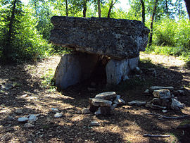 The Dolmen of the Aurie Lake known as "Pech Lapeyre" in Limogne-en-Quercy | |
 Coat of arms | |
show Location of Limogne-en-Quercy | |
 Limogne-en-Quercy | |
| Coordinates: 44°23′54″N 1°46′16″E / 44.3983°N 1.7711°ECoordinates: 44°23′54″N 1°46′16″E / 44.3983°N 1.7711°E | |
| Country | France |
| Region | Occitanie |
| Department | Lot |
| Arrondissement | Cahors |
| Canton | Marches du Sud-Quercy |
| Government | |
| • Mayor (2021–2026) | Jean-Claude Vialette[1] |
| Area 1 | 32.31 km2 (12.47 sq mi) |
| Population (Jan. 2018)[2] | 735 |
| • Density | 23/km2 (59/sq mi) |
| Time zone | UTC+01:00 (CET) |
| • Summer (DST) | UTC+02:00 (CEST) |
| INSEE/Postal code | 46173 /46260 |
| Elevation | 214–403 m (702–1,322 ft) |
| 1 French Land Register data, which excludes lakes, ponds, glaciers > 1 km2 (0.386 sq mi or 247 acres) and river estuaries. | |


Limogne-en-Quercy (French pronunciation: [limɔɲ ɑ̃ kɛʁsi], literally Limogne in Quercy; Occitan: Limonha de Carcin) is a commune in the Lot department in south-western France.

Monument to those from the commune who died in World War I and World War II
See also[]
- Communes of the Lot department
References[]
- ^ "Répertoire national des élus: les maires". data.gouv.fr, Plateforme ouverte des données publiques françaises (in French). 9 August 2021.
- ^ "Populations légales 2018". INSEE. 28 December 2020.
| Wikimedia Commons has media related to Limogne-en-Quercy. |
| show Communes of the Lot department |
|---|
| show Authority control |
|---|
This Lot geographical article is a stub. You can help Wikipedia by . |
Categories:
- Communes of Lot (department)
- Quercy
- Lot (department) geography stubs