List of Valley Metro Rail stations
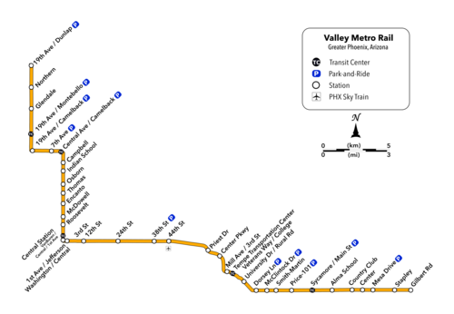
Valley Metro Rail is a light rail transit system that serves the Phoenix metropolitan area in Arizona, United States. The light rail system, which operates under the Valley Metro brand name, has 38 stations and 26 miles (42 km) of tracks within the cities of Phoenix, Tempe, and Mesa.[1] The system serves on average over 49,400 weekday riders as of 2016,[2] making it one of the busiest light rail systems in the United States.
Valley Metro Rail opened its initial 20-mile (32 km) starter line[3] on December 27, 2008.[4] The starter line, which was funded through a combination of federal, regional and local municipal funds,[5] operated from the 19th Avenue/Montebello station in Phoenix, through Tempe, serving the Arizona State University Tempe campus, and ended at the Sycamore/Main Street station in Mesa.[6] The starter line provided service to 28 stations in total, which were primarily located on-street at the intersections of major arterial roads every 0.5 miles (0.80 km), although mid-block stations are common in areas of higher urban density. On April 8, 2013, the PHX Sky Train people mover opened, providing direct service from the 44th Street/Washington station to Phoenix Sky Harbor International Airport.[7] On August 22, 2015, Valley Metro's first light rail extension, the Central Mesa Extension, opened, which added four new stations on the eastern end of the starter line going through downtown Mesa, including a new terminus at Mesa Drive/Main Street station.[8] The second light rail extension, the Northwest Extension Phase I opened on March 19, 2016, which added three new stations on the western end of the starter line on 19th Avenue, including a new terminus at 19th Avenue/Dunlap station.[9]
Three new stations opened on 2019. Two of these, Stapley/Main Street station and Gilbert Road/Main Street station, are part of the Gilbert Road Extension, which began service at May 2019.[10][11] The third station, 50th Street/Washington station, is an infill station located between the 44th Street/Washington station and Priest Drive/Washington station in Phoenix.[12] This station opened in April 2019, and was funded by Proposition 104, Phoenix's 2015 ballot initiative that extended and expanded the city's transportation sales tax.[13]
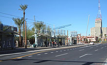
Each light rail station is approximately 300 feet (91 m) long, which allows up to three separate light rail vehicles to be linked into one train (each light rail vehicle is 90 feet (27 m) long).[14] Access is primarily provided at the end of the stations, usually at signalized intersections. All stations maintain a similar design, are ADA accessible and provide level boarding throughout. Each station consists of a platform and an overhead canopy that provides shade and shelter from the weather. Station amenities include seating, trash canisters, a drinking fountain, lighting, digital and vocal rider information, emergency call boxes and public art. Fares can be purchased at the ticket vending machines located at each end of the station platforms.[15] Five of the stations have associated transit centers for transferring between light rail and buses.[16] 10 of the stations have associated park-and-ride facilities that provide approximately 4,500 public parking spaces combined along the entire light rail system.[17]
Valley Metro is currently in various phases of planning and development on six light rail extensions. Combined, these extensions will expand the light rail system by 37 miles (60 km) by the year 2034.[18] Three of these extensions have completed a sufficient amount of planning to determine the number of stations they will include. The Gilbert Road Extension, as discussed previously, will add two stations; the Northwest Extension Phase 2 will add three stations;[19] and the South Central Extension will add seven stations.[20] The other two extensions are still going through the station selection process. The Capitol/I-10 West Extension will add approximately ten new light rail stations,[21] while the West Phoenix/Central Glendale Extension will add approximately seven new light rail stations.[22] The Northeast Extension has not begun the planning process, and thus the number of stations have yet to be determined.[23] Valley Metro is also developing the Tempe Streetcar in downtown Tempe, which will have 14 stops along its 3-mile (4.8 km) alignment. Two of these stops will directly interface with the existing light rail stations at Mill Avenue/Third Street station and Dorsey/Apache Boulevard station.[24] After the completion of all of these extensions and the 50th St/Washington infill station, the Phoenix metropolitan area will have 63 miles (101 km) of light rail and over 65 separate light rail stations. As part of Phoenix's Proposition 104, various new extensions have been proposed, although none of these have been formally adopted by Valley Metro Rail's Board of Directors.[25] As of June 2017, the configuration of the entire system, including the number of distinct light rail services, has yet to be determined.
Stations[]


| † | Terminal station |
| Park and ride station | |
| Transport hub | |
| Transfer to PHX Sky Train |

Under construction[]
| Station[note 1] | Extension | City | Opening | Platform Type | Coordinates | Ref(s) |
|---|---|---|---|---|---|---|
| Metrocenter † |
Northwest Phase II | Phoenix | 2024 | |||
| Northwest Phase II | Phoenix | 2024 | ||||
| Northwest Phase II | Phoenix | 2024 | ||||
| 3rd Street Loop † | South Central | Phoenix | 2024 | Side | ||
| Downtown Hub | South Central | Phoenix | 2024 | |||
| Lincoln/1st Avenue[note 3] | South Central | Phoenix | 2024 | Side | ||
| Lincoln/Central Avenue[note 3] | South Central | Phoenix | 2024 | Side | ||
| Buckeye/Central Avenue | South Central | Phoenix | 2024 | Island | ||
| Pioneer/Central Avenue | South Central | Phoenix | 2024 | Island | ||
| Broadway/Central Avenue |
South Central | Phoenix | 2024 | Island | ||
| Roeser/Central Avenue | South Central | Phoenix | 2024 | Island | ||
| Southern/Central Avenue | South Central | Phoenix | 2024 | Island | 33°23′29″N 112°04′24″W / 33.391464°N 112.073318°W | |
| Baseline/Central Avenue † |
South Central | Phoenix | 2024 | Island | 33°22′44″N 112°04′24″W / 33.378757°N 112.073281°W |
See also[]
| Wikimedia Commons has media related to Valley Metro Rail stations. |
Notes[]
References[]
- ^ "Light Rail System Fact Sheet" (PDF), Valley Metro Fact Sheets, Valley Metro Rail, archived (PDF) from the original on 2016-06-04, retrieved April 30, 2016
- ^ "Ridership Report 2016" (PDF), Valley Metro Ridership Reports, Valley Metro Rail, archived (PDF) from the original on 2016-08-01, retrieved April 30, 2016
- ^ "2013 Light Rail System Fact Sheet" (PDF), Valley Metro Fact Sheets, Valley Metro Rail, archived (PDF) from the original on 2016-08-19, retrieved July 1, 2016
- ^ Jump up to: a b c d e f g h i j k l m n o p q r s t u v w x y z aa ab ac ad ae af ag ah Nunez, Dianna (December 26, 2008), "Grand opening of light rail system Saturday", The Arizona Republic, retrieved April 30, 2016
- ^ Creno, Glen (December 9, 2008), "Coping with light rail costs", The Arizona Republic, retrieved April 30, 2016
- ^ "Valley Metro System Fact Sheet" (PDF), Valley Metro Fact Sheets, Valley Metro Rail, archived (PDF) from the original on 2016-06-04, retrieved April 30, 2016
- ^ Wang, Amy B. (April 5, 2013), "Phoenix readies train to move Sky Harbor airport passengers", The Arizona Republic, retrieved April 30, 2016
- ^ Jump up to: a b c d e Mitchell, Garrett (August 22, 2015), "Mesa light rail expansion debuts to thousands of riders", The Arizona Republic, retrieved April 30, 2016
- ^ Jump up to: a b c d Goth, Brenna (March 18, 2016), "Northwest light rail extension opens in Phoenix Saturday", The Arizona Republic, retrieved April 30, 2016
- ^ Jump up to: a b c "Gilbert Road Light Rail Extension Fact Sheet" (PDF). Valley Metro. April 2019. Retrieved April 26, 2019.
- ^ Jump up to: a b c "Celebrate with us on May 18! Two more miles of light rail open in Mesa. | Valley Metro". www.valleymetro.org. Retrieved 2019-05-20.
- ^ Jump up to: a b "50th Street Station Project", Valley Metro Projects and Planning, Valley Metro Rail, archived from the original on 2016-05-14, retrieved April 30, 2016
- ^ Sunnucks, Mike (August 27, 2015), "Prop. 104 supporters lay out what's next for Phoenix following measure's passage", Phoenix Business Journal, archived from the original on June 3, 2016, retrieved June 4, 2016
- ^ "Light Rail Vehicle" (PDF), Valley Metro Fact Sheets, Valley Metro Rail, archived (PDF) from the original on 2016-06-04, retrieved April 30, 2016
- ^ "Station Platforms" (PDF), Valley Metro Fact Sheets, Valley Metro Rail, archived (PDF) from the original on 2016-06-04, retrieved April 30, 2016
- ^ "Light Rail Transit Centers", Valley Metro Transit Centers, Valley Metro Rail, archived from the original on 2016-04-17, retrieved April 30, 2016
- ^ "Light Rail Park-and-rides", Valley Metro Park-and-rides, Valley Metro Rail, archived from the original on 2016-05-13, retrieved April 30, 2016
- ^ "Future Transit Corridors", Valley Metro Publications/Reports, Valley Metro Rail, archived from the original on 2016-04-17, retrieved May 14, 2016
- ^ "Northwest Phase II", Valley Metro Projects and Planning, Valley Metro Rail, archived from the original on 2016-05-20, retrieved May 14, 2016
- ^ "South Central", Valley Metro Projects and Planning, Valley Metro Rail, archived from the original on 2016-05-31, retrieved May 14, 2016
- ^ "Capitol/I-10 West", Valley Metro Projects and Planning, Valley Metro Rail, archived from the original on 2016-05-13, retrieved May 14, 2016
- ^ "West Phoenix/Central Glendale", Valley Metro Projects and Planning, Valley Metro Rail, archived from the original on 2016-05-31, retrieved May 14, 2016
- ^ "Northeast", Valley Metro Projects and Planning, Valley Metro Rail, archived from the original on 2016-06-04, retrieved May 14, 2016
- ^ "Tempe Streetcar", Valley Metro Projects and Planning, Valley Metro Rail, archived from the original on 2017-07-19, retrieved May 14, 2016
- ^ Goth, Brenna (August 26, 2015), "Phoenix voters pass Prop. 104 transit tax", Arizona Republic, retrieved May 14, 2016
- ^ "Weekday Rail Passengers by Station FY 2021", Valley Metro Ridership Reports, Valley Metro Rail, retrieved July 30, 2021
- ^ Jump up to: a b c "Northwest Phase I", Valley Metro Projects and Planning, Valley Metro Rail, archived from the original on April 14, 2016, retrieved April 16, 2016
- ^ Jump up to: a b c d e f g h i j k l m n o p q r s t u v w x y z aa ab ac ad ae af ag "Valley Metro System Map" (PDF), Valley Metro Planning Your Trip, Valley Metro Rail, archived from the original (PDF) on May 8, 2016, retrieved May 14, 2016
- ^ Boehm, Jessica (April 24, 2019). "Phoenix opens new, accessible light rail station as movement to kill rail program heats up". Arizona Republic. Retrieved April 26, 2019.
- ^ Jump up to: a b c d "Central Mesa Extension", Valley Metro Projects and Planning, Valley Metro Rail, archived from the original on 2016-04-17, retrieved April 16, 2016
- Valley Metro Rail
- Valley Metro Rail stations
- Lists of railway stations in the United States
- Transportation buildings and structures in Phoenix, Arizona
- Lists of buildings and structures in Arizona