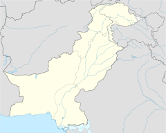
List of extreme points of Pakistan
K2
Murkushi
Sir Creek
Gyong La pass
Pakistan, Iran & Afghanistan tripoint
Broghil Pass
Gharota
Tirich Mir
class=notpageimage|
Extreme points of PakistanThis is a list of the extreme points of Pakistan.
Extreme points[]
| Heading | Location | Administrative entity | Bordering entity | Coordinates[note 1] |
|---|---|---|---|---|
| North (disputed, administered) |
Murkushi west of the Khunjerab Pass |
Gilgit–Baltistan | Xinjiang, People's Republic of China | 37°05′01″N 74°41′26″E / 37.0837°N 74.6906°E |
| North (undisputed) |
Tri-junction of Khyber Pakhtunkhwa, Gilgit-Baltistan and Afghanistan just to the east of Broghil Pass | Khyber Pakhtunkhwa | Badakhshan Province, Afghanistan / Gilgit-Baltistan | 36°54′42″N 73°40′18″E / 36.9116°N 73.6717°E |
| South | Keti Bunder South Wildlife Sanctuary, South Island near Sir Creek, Thatta |
Sindh | Arabian Sea | 23°42′59″N 68°09′49″E / 23.7164°N 68.1636°E |
| East (disputed, administered) |
near Gyong La, AGPL | Gilgit–Baltistan | Ladakh, India | 35°03′54″N 77°07′13″E / 35.0651°N 77.1202°E |
| East (undisputed) |
near Gharota, Shakargarh Tehsil, Punjab | Punjab, Pakistan | Punjab, India | |
| East (disputed, claimed) |
Demchok, Ladakh | Ladakh | Ladakh | |
| West | The point where Pakistan, Iran and Afghanistan meet in Balochistan, near Maki. | Balochistan | Iran & Afghanistan | 29°51′31″N 60°52′29″E / 29.8585°N 60.8746°E |
Extreme altitude[]
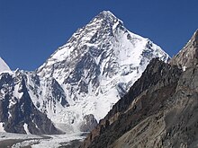
K2 in Gilgit–Baltistan is the second-highest mountain on Earth.
| Extremity | Name | Altitude | Location | Province/Territory | Coordinates |
|---|---|---|---|---|---|
| Highest (disputed) | K2[1] | 8,611 m (28,251 ft) | Border between Gilgit–Baltistan and Xinjiang | Gilgit–Baltistan | 35°52′57″N 76°30′48″E / 35.88250°N 76.51333°E |
| Highest (undisputed) | Tirich Mir[2] | 7,708 m (25,289 ft) | Chitral District | Khyber Pakhtunkhwa | 36°15′51″N 71°50′36″E / 36.26416°N 71.84333°E |
| Lowest | Near Sir Creek, Thatta | 0 m (0.0 ft) | Thatta District | Sindh | 23°41′42″N 68°08′56″E / 23.695°N 68.149°E |
Internal points[]
| Province 1 | Province 2 | Province 3 | Location | Notes |
|---|---|---|---|---|
| Azad Jammu & Kashmir | Khyber Pakhtunkhwa | Punjab | 34°00′07″N 73°51′41″E / 34.00194°N 73.86139°E | Manwan Ni Hel serves as the closest populated village to the tripoint. The actual tripoint is located in the Jhelum River. |
| Punjab | Khyber Pakhtunkhwa | Islamabad Capital Territory | 33°47′54″N 73°10′46″E / 33.79833°N 73.17944°E | Eastern tripoint |
| Punjab | Khyber Pakhtunkhwa | Islamabad Capital Territory | 33°43′29″N 72°55′37″E / 33.72472°N 72.92694°E | Shah Allah Ditta serves as the closest populated village to the tripoint Western tripoint |
| Khyber Pakhtunkhwa | Gilgit-Baltistan | Azad Jammu & Kashmir | 35°06′39″N 74°08′00″E / 35.11083°N 74.13333°E | The tripoint is located at the eastern periphery of Lulusar-Dudipatsar National Park |
| Khyber Pakhtunkhwa | Balochistan | Punjab | 31°03′26″N 70°14′46″E / 31.05722°N 70.24611°E | Chitarwata Post |
| Punjab | Balochistan | Sindh | 28°27′21″N 69°22′07″E / 28.45583°N 69.36861°E |
See also[]
- Geography of Pakistan
- Extreme points of Asia
- List of Pakistani provinces by highest elevation
Notes[]
- ^ Coordinates obtained from Google Earth. Google Earth makes use of the WGS84 geodetic reference system.
References[]
Pakistan articles | |||||||||||||||||||
|---|---|---|---|---|---|---|---|---|---|---|---|---|---|---|---|---|---|---|---|
| |||||||||||||||||||
| |||||||||||||||||||
| |||||||||||||||||||
| |||||||||||||||||||
| |||||||||||||||||||
| |||||||||||||||||||
| Sovereign states |
|
|---|---|
| States with limited recognition |
|
| Dependencies and other territories | |
| |
Categories:
- Geography of Pakistan
- Extreme points by country