List of mountain peaks of Utah

This article comprises three sortable tables of major mountain peaks[1] of the U.S. State of Utah.
The summit of a mountain or hill may be measured in three principal ways:
- The topographic elevation of a summit measures the height of the summit above a geodetic sea level.[2][3] The first table below ranks the 50 highest major summits of Utah by elevation.
- The topographic prominence of a summit is a measure of how high the summit rises above its surroundings.[4][3] The second table below ranks the 50 most prominent summits of Utah.
- The topographic isolation (or radius of dominance) of a summit measures how far the summit lies from its nearest point of equal elevation.[5] The third table below ranks the 50 most isolated major summits of Utah.
Highest major summits[]
Of the highest major summits of Utah, Kings Peak exceeds 4000 meters (13,123 feet) elevation, 14 peaks exceed 3500 meters (11,483 feet), and 43 peaks exceed 3000 meters (9843 feet) elevation.

Most prominent summits[]
Of the most prominent summits of Utah, eight peaks are ultra-prominent summits with more than 1500 meters (4921 feet) of topographic prominence and 33 peaks exceed 1000 meters (3281 feet) of topographic prominence.
Most isolated major summits[]
Of the most isolated major summits of Utah, Kings Peak exceeds 200 kilometers (124.3 miles) of topographic isolation and four peaks exceed 100 kilometers (62.14 miles) of topographic isolation.
Gallery[]

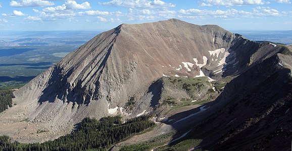
Kings Peak

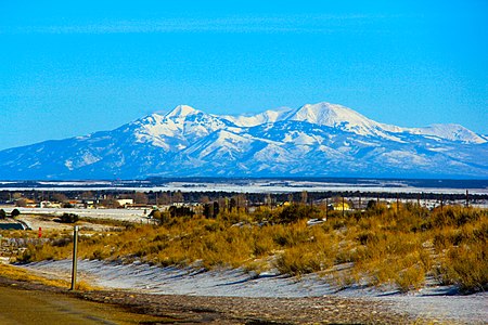
Mount Nebo is the highest summit of the Wasatch Range.

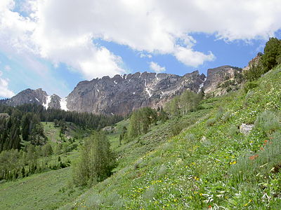
Mount Timpanogos


See also[]
- List of mountain peaks of North America
- List of mountain peaks of Greenland
- List of mountain peaks of Canada
- List of mountain peaks of the Rocky Mountains
- List of mountain peaks of the United States
- List of mountain peaks of Alaska
- List of mountain peaks of Arizona
- List of mountain peaks of California
- List of mountain peaks of Colorado
- List of mountain peaks of Hawaiʻi
- List of mountain peaks of Idaho
- List of mountain peaks of Montana
- List of mountain peaks of Nevada
- List of mountain peaks of New Mexico
- List of mountain peaks of Oregon
- List of mountain peaks of Utah
- List of mountains of Utah
- List of mountain ranges of Utah
- List of mountain peaks of Washington (state)
- List of mountain peaks of Wyoming
- List of mountain peaks of México
- List of mountain peaks of Central America
- List of mountain peaks of the Caribbean
- Utah
- Geography of Utah
- Category:Mountains of Utah
- Geography of Utah
- Physical geography
Notes[]
- ^ Jump up to: a b c The summit of Kings Peak is the highest point of the Uinta Mountains, the U.S. State of Utah, and the western Rocky Mountains.
- ^ Jump up to: a b c The elevation of Kings Peak includes an adjustment of +1.807 m (5.93 ft) from NGVD 29 to NAVD 88.
- ^ Jump up to: a b c The summit of Mount Peale is the highest point of the La Sal Mountains and the Colorado Plateau.
- ^ Jump up to: a b c The summit of Delano Peak is the highest point of the Tushar Mountains.
- ^ Jump up to: a b c The summit of Ibapah Peak is the highest point of the Deep Creek Range.
- ^ Jump up to: a b c The elevation of Ibapah Peak includes an adjustment of +1.517 m (4.98 ft) from NGVD 29 to NAVD 88.
- ^ The elevation of Bald Mountain includes an adjustment of +1.59 m (5.22 ft) from NGVD 29 to NAVD 88.
- ^ Jump up to: a b c The summit of Mount Nebo is the highest point of the Wasatch Range.
- ^ Jump up to: a b c The elevation of Mount Nebo includes an adjustment of +1.395 m (4.58 ft) from NGVD 29 to NAVD 88.
- ^ The elevation of South Mountain includes an adjustment of +1.437 m (4.71 ft) from NGVD 29 to NAVD 88.
- ^ Jump up to: a b c The summit of Mount Timpanogos is the highest point of the central Wasatch Range.
- ^ Jump up to: a b c The summit of is the highest point of the .
- ^ Jump up to: a b The elevation of includes an adjustment of +1.615 m (5.3 ft) from NGVD 29 to NAVD 88.
- ^ Jump up to: a b c The summit of Mount Ellen Peak is the highest point of the Henry Mountains.
- ^ Jump up to: a b c The elevation of Mount Ellen Peak includes an adjustment of +1.486 m (4.88 ft) from NGVD 29 to NAVD 88.
- ^ Jump up to: a b c The elevation of Twin Peaks includes an adjustment of +1.463 m (4.8 ft) from NGVD 29 to NAVD 88.
- ^ Jump up to: a b c The summit of Abajo Peak is the highest point of the Abajo Mountains.
- ^ Jump up to: a b c The elevation of Bluebell Knoll includes an adjustment of +1.708 m (5.6 ft) from NGVD 29 to NAVD 88.
- ^ Jump up to: a b c The summit of Brian Head is the highest point of the Markagunt Plateau.
- ^ Jump up to: a b c The elevation of Brian Head includes an adjustment of +1.556 m (5.1 ft) from NGVD 29 to NAVD 88.
- ^ Jump up to: a b c The summit of is the highest point of the Wasatch Plateau.
- ^ Jump up to: a b c The summit of is the highest point of the .
- ^ Jump up to: a b c The elevation of Provo Peak includes an adjustment of +1.31 m (4.3 ft) from NGVD 29 to NAVD 88.
- ^ Jump up to: a b c The summit of Deseret Peak is the highest point of the Stansbury Mountains.
- ^ The elevation of includes an adjustment of +1.423 m (4.67 ft) from NGVD 29 to NAVD 88.
- ^ Jump up to: a b c The elevation of Mount Hillers includes an adjustment of +1.364 m (4.48 ft) from NGVD 29 to NAVD 88.
- ^ Jump up to: a b c The summit of Flat Top Mountain is the highest point of the Oquirrh Mountains.
- ^ Jump up to: a b c The elevation of Flat Top Mountain includes an adjustment of +1.329 m (4.36 ft) from NGVD 29 to NAVD 88.
- ^ Jump up to: a b c The summit of Signal Peak is the highest point of the Pine Valley Mountains.
- ^ Jump up to: a b c The elevation of Signal Peak includes an adjustment of +1.249 m (4.1 ft) from NGVD 29 to NAVD 88.
- ^ Jump up to: a b c The summit of is the highest point of the Roan Cliffs.
- ^ Jump up to: a b c The summit of is the highest point of the Pavant Range.
- ^ Jump up to: a b c The elevation of includes an adjustment of +1.418 m (4.65 ft) from NGVD 29 to NAVD 88.
- ^ Jump up to: a b c The summit of is the highest point of the San Pitch Mountains.
- ^ Jump up to: a b The elevation of Shay Mountain includes an adjustment of +1.249 m (4.1 ft) from NGVD 29 to NAVD 88.
- ^ Jump up to: a b c The summit of Naomi Peak is the highest point of the Bear River Mountains.
- ^ Jump up to: a b c The summit of Bull Mountain is the highest point of the Raft River Mountains.
- ^ Jump up to: a b c The elevation of Bull Mountain includes an adjustment of +1.343 m (4.41 ft) from NGVD 29 to NAVD 88.
- ^ Jump up to: a b The elevation of includes an adjustment of +1.222 m (4.01 ft) from NGVD 29 to NAVD 88.
- ^ Jump up to: a b c The summit of is the highest point of the .
- ^ Jump up to: a b c The elevation of includes an adjustment of +1.374 m (4.51 ft) from NGVD 29 to NAVD 88.
- ^ Jump up to: a b c The summit of is the highest point of the northern Wasatch Range.
- ^ Jump up to: a b c The summit of Fool Creek Peak is the highest point of the Canyon Mountains.
- ^ Jump up to: a b c The summit of Swasey Peak is the highest point of the House Range.
- ^ Jump up to: a b c The summit elevation of Swasey Peak includes a vertical offset of +0.61 m (2 ft) from the station benchmark.
- ^ Jump up to: a b c The summit of Frisco Peak is the highest point of the San Francisco Mountains.
- ^ Jump up to: a b The summit of is the highest point of the Beaver Dam Mountains.
- ^ Jump up to: a b The summit of is the highest point of the Fish Springs Range.
- ^ Jump up to: a b The summit of is the highest point of the .
- ^ Jump up to: a b The summit elevation of Notch Peak includes a vertical offset of +0.102 m (0.3 ft) from the station benchmark.
- ^ Jump up to: a b The summit of is the highest point of the Wah Wah Mountains.
- ^ Jump up to: a b The summit of is the highest point of the Mineral Mountains.
- ^ Jump up to: a b The summit elevation of includes a vertical offset of +0.61 m (2 ft) from the station benchmark.
References[]
- ^ This article defines a significant summit as a summit with at least 100 meters (328.1 feet) of topographic prominence, and a major summit as a summit with at least 500 meters (1640 feet) of topographic prominence. All summits in this article have at least 500 meters of topographic prominence. An ultra-prominent summit is a summit with at least 1500 meters (4921 feet) of topographic prominence.
- ^ All elevations in this article include an elevation adjustment from the National Geodetic Vertical Datum of 1929 (NGVD 29) to the North American Vertical Datum of 1988 (NAVD 88). For further information, please see this United States National Geodetic Survey note.
- ^ Jump up to: a b If the elevation or prominence of a summit is calculated as a range of values, the arithmetic mean is shown.
- ^ The topographic prominence of a summit is the topographic elevation difference between the summit and its highest or key col to a higher summit. The summit may be near its key col or quite far away. The key col for Denali in Alaska is the Isthmus of Rivas in Nicaragua, 7642 kilometers (4749 miles) away.
- ^ The topographic isolation of a summit is the great-circle distance to its nearest point of equal elevation.
- ^ Jump up to: a b c "Kings Peak". Geographic Names Information System. United States Geological Survey.
- ^ Jump up to: a b c "Kings Peak". Peakbagger.com. Retrieved 14 June 2016.
- ^ Jump up to: a b c "Kings Peak". Bivouac.com. Retrieved 14 June 2016.
- ^ Jump up to: a b c "MOUNT PEALE". Datasheet for NGS Station JM0496. U.S. National Geodetic Survey. Retrieved 14 June 2016.
- ^ Jump up to: a b c "Mount Peale". Geographic Names Information System. United States Geological Survey.
- ^ Jump up to: a b c "Mount Peale". Peakbagger.com. Retrieved 14 June 2016.
- ^ Jump up to: a b c "Mount Peale". Bivouac.com. Retrieved 14 June 2016.
- ^ "MOUNT WAAS RESET". Datasheet for NGS Station JM0478. U.S. National Geodetic Survey. Retrieved 14 June 2016.
- ^ "Mount Waas". Geographic Names Information System. United States Geological Survey.
- ^ "Mount Waas". Peakbagger.com. Retrieved 14 June 2016.
- ^ "Mount Waas". Bivouac.com. Retrieved 14 June 2016.
- ^ Jump up to: a b c "DELANO PEAK M 5". Datasheet for NGS Station JO0502. U.S. National Geodetic Survey. Retrieved 14 June 2016.
- ^ Jump up to: a b c "Delano Peak". Geographic Names Information System. United States Geological Survey.
- ^ Jump up to: a b c "Delano Peak". Peakbagger.com. Retrieved 14 June 2016.
- ^ Jump up to: a b c "Delano Peak". Bivouac.com. Retrieved 14 June 2016.
- ^ Jump up to: a b c "Ibapah Peak". Geographic Names Information System. United States Geological Survey.
- ^ Jump up to: a b c "Ibapah Peak". Peakbagger.com. Retrieved 14 June 2016.
- ^ Jump up to: a b c "Ibapah Peak". Bivouac.com. Retrieved 14 June 2016.
- ^ "BALD MTN CAIRN". Datasheet for NGS Station LO1135. U.S. National Geodetic Survey. Retrieved 14 June 2016.
- ^ "Bald Mountain". Geographic Names Information System. United States Geological Survey.
- ^ "Bald Mountain". Peakbagger.com. Retrieved 14 June 2016.
- ^ "Bald Mountain". Bivouac.com. Retrieved 14 June 2016.
- ^ Jump up to: a b c "Mount Nebo". Geographic Names Information System. United States Geological Survey.
- ^ Jump up to: a b c "Mount Nebo". Peakbagger.com. Retrieved 14 June 2016.
- ^ Jump up to: a b c "Mount Nebo". Bivouac.com. Retrieved 14 June 2016.
- ^ "South Mountain". Geographic Names Information System. United States Geological Survey.
- ^ "South Mountain". Peakbagger.com. Retrieved 14 June 2016.
- ^ "South Mountain". Bivouac.com. Retrieved 14 June 2016.
- ^ Jump up to: a b c "TIMPANOGOS". Datasheet for NGS Station LO0769. U.S. National Geodetic Survey. Retrieved 14 June 2016.
- ^ Jump up to: a b c "Mount Timpanogos". Geographic Names Information System. United States Geological Survey.
- ^ Jump up to: a b c "Mount Timpanogos". Peakbagger.com. Retrieved 14 June 2016.
- ^ Jump up to: a b c "Mount Timpanogos". Bivouac.com. Retrieved 14 June 2016.
- ^ Jump up to: a b c "FISH LAKE". Datasheet for NGS Station JN0377. U.S. National Geodetic Survey. Retrieved 14 June 2016.
- ^ Jump up to: a b c "Fish Lake Hightop". Peakbagger.com. Retrieved 14 June 2016.
- ^ Jump up to: a b c "Fish Lake Hightop". Bivouac.com. Retrieved 14 June 2016.
- ^ Jump up to: a b c "MOUNT MARVINE". Datasheet for NGS Station JN0380. U.S. National Geodetic Survey. Retrieved 14 June 2016.
- ^ Jump up to: a b c "Mount Marvine". Geographic Names Information System. United States Geological Survey.
- ^ Jump up to: a b c "Mount Marvine". Peakbagger.com. Retrieved 14 June 2016.
- ^ Jump up to: a b c "Mount Marvine". Bivouac.com. Retrieved 14 June 2016.
- ^ Jump up to: a b "Mount Hilgard". Geographic Names Information System. United States Geological Survey.
- ^ Jump up to: a b "Mount Hilgard". Peakbagger.com. Retrieved 14 June 2016.
- ^ Jump up to: a b "Mount Hilgard". Bivouac.com. Retrieved 14 June 2016.
- ^ Jump up to: a b c "Mount Ellen Peak". Geographic Names Information System. United States Geological Survey.
- ^ Jump up to: a b c "Mount Ellen Peak". Peakbagger.com. Retrieved 14 June 2016.
- ^ Jump up to: a b c "Mount Ellen Peak". Bivouac.com. Retrieved 14 June 2016.
- ^ Jump up to: a b c "Twin Peaks". Geographic Names Information System. United States Geological Survey.
- ^ Jump up to: a b c "Twin Peaks". Peakbagger.com. Retrieved 14 June 2016.
- ^ Jump up to: a b c "Twin Peaks". Bivouac.com. Retrieved 14 June 2016.
- ^ Jump up to: a b c "PENNELL". Datasheet for NGS Station HN1004. U.S. National Geodetic Survey. Retrieved 14 June 2016.
- ^ Jump up to: a b c "Mount Pennell". Geographic Names Information System. United States Geological Survey.
- ^ Jump up to: a b c "Mount Pennell". Peakbagger.com. Retrieved 14 June 2016.
- ^ Jump up to: a b c "Mount Pennell". Bivouac.com. Retrieved 14 June 2016.
- ^ Jump up to: a b c "ABAJO PEAK". Datasheet for NGS Station HM0536. U.S. National Geodetic Survey. Retrieved 14 June 2016.
- ^ Jump up to: a b c "Abajo Peak". Geographic Names Information System. United States Geological Survey.
- ^ Jump up to: a b c "Abajo Peak". Peakbagger.com. Retrieved 14 June 2016.
- ^ Jump up to: a b c "Abajo Peak". Bivouac.com. Retrieved 14 June 2016.
- ^ Jump up to: a b c "Bluebell Knoll". Geographic Names Information System. United States Geological Survey.
- ^ Jump up to: a b c "Bluebell Knoll". Peakbagger.com. Retrieved 14 June 2016.
- ^ Jump up to: a b c "Bluebell Knoll". Bivouac.com. Retrieved 14 June 2016.
- ^ Jump up to: a b "CIRCLEVILLE". Datasheet for NGS Station JO0499. U.S. National Geodetic Survey. Retrieved 14 June 2016.
- ^ Jump up to: a b "Circleville Mountain". Geographic Names Information System. United States Geological Survey.
- ^ Jump up to: a b "Circleville Mountain". Peakbagger.com. Retrieved 14 June 2016.
- ^ Jump up to: a b "Circleville Mountain". Bivouac.com. Retrieved 14 June 2016.
- ^ Jump up to: a b c "Brian Head". Geographic Names Information System. United States Geological Survey.
- ^ Jump up to: a b c "Brian Head". Peakbagger.com. Retrieved 14 June 2016.
- ^ Jump up to: a b c "Brian Head". Bivouac.com. Retrieved 14 June 2016.
- ^ Jump up to: a b c "THOUSAND LAKE MTN". Datasheet for NGS Station JN0361. U.S. National Geodetic Survey. Retrieved 14 June 2016.
- ^ Jump up to: a b c "Thousand Lake Mountain". Geographic Names Information System. United States Geological Survey.
- ^ Jump up to: a b c "Thousand Lake Mountain". Peakbagger.com. Retrieved 14 June 2016.
- ^ Jump up to: a b c "Thousand Lake Mountain". Bivouac.com. Retrieved 14 June 2016.
- ^ Jump up to: a b c "SOUTH TENT". Datasheet for NGS Station KN0397. U.S. National Geodetic Survey. Retrieved 14 June 2016.
- ^ Jump up to: a b c "South Tent Mountain". Geographic Names Information System. United States Geological Survey.
- ^ Jump up to: a b c "South Tent Mountain". Peakbagger.com. Retrieved 14 June 2016.
- ^ Jump up to: a b c "South Tent Mountain". Bivouac.com. Retrieved 14 June 2016.
- ^ Jump up to: a b c "MONROE PEAK 13". Datasheet for NGS Station JO0474. U.S. National Geodetic Survey. Retrieved 14 June 2016.
- ^ Jump up to: a b c "Monroe Peak". Geographic Names Information System. United States Geological Survey.
- ^ Jump up to: a b c "Monroe Peak". Peakbagger.com. Retrieved 14 June 2016.
- ^ Jump up to: a b c "Monroe Peak". Bivouac.com. Retrieved 14 June 2016.
- ^ Jump up to: a b c "MONROE 2". Datasheet for NGS Station JO0472. U.S. National Geodetic Survey. Retrieved 14 June 2016.
- ^ Jump up to: a b c "Glenwood Mountain". Geographic Names Information System. United States Geological Survey.
- ^ Jump up to: a b c "Glenwood Mountain". Peakbagger.com. Retrieved 14 June 2016.
- ^ Jump up to: a b c "Glenwood Mountain". Bivouac.com. Retrieved 14 June 2016.
- ^ Jump up to: a b c "Provo Peak". Geographic Names Information System. United States Geological Survey.
- ^ Jump up to: a b c "Provo Peak". Peakbagger.com. Retrieved 14 June 2016.
- ^ Jump up to: a b c "Provo Peak". Bivouac.com. Retrieved 14 June 2016.
- ^ Jump up to: a b c "MT DUTTON". Datasheet for NGS Station JO0491. U.S. National Geodetic Survey. Retrieved 14 June 2016.
- ^ Jump up to: a b c "Mount Dutton". Geographic Names Information System. United States Geological Survey.
- ^ Jump up to: a b c "Mount Dutton". Peakbagger.com. Retrieved 14 June 2016.
- ^ Jump up to: a b c "Mount Dutton". Bivouac.com. Retrieved 14 June 2016.
- ^ Jump up to: a b c "Deseret Peak". Geographic Names Information System. United States Geological Survey.
- ^ Jump up to: a b c "Deseret Peak". Peakbagger.com. Retrieved 14 June 2016.
- ^ Jump up to: a b c "Deseret Peak". Bivouac.com. Retrieved 14 June 2016.
- ^ "BALD MTN". Datasheet for NGS Station KN0447. U.S. National Geodetic Survey. Retrieved 14 June 2016.
- ^ "Bald Mountain". Geographic Names Information System. United States Geological Survey.
- ^ "Bald Mountain". Peakbagger.com. Retrieved 14 June 2016.
- ^ "Bald Mountain". Bivouac.com. Retrieved 14 June 2016.
- ^ "Rocky Peak". Geographic Names Information System. United States Geological Survey.
- ^ "Rocky Peak". Peakbagger.com. Retrieved 14 June 2016.
- ^ "Rocky Peak". Bivouac.com. Retrieved 14 June 2016.
- ^ Jump up to: a b c "Mount Hillers". Geographic Names Information System. United States Geological Survey.
- ^ Jump up to: a b c "Mount Hillers". Peakbagger.com. Retrieved 14 June 2016.
- ^ Jump up to: a b c "Mount Hillers". Bivouac.com. Retrieved 14 June 2016.
- ^ Jump up to: a b c "LOAFER". Datasheet for NGS Station KN0422. U.S. National Geodetic Survey. Retrieved 14 June 2016.
- ^ Jump up to: a b c "Loafer Mountain". Geographic Names Information System. United States Geological Survey.
- ^ Jump up to: a b c "Loafer Mountain". Peakbagger.com. Retrieved 14 June 2016.
- ^ Jump up to: a b c "Loafer Mountain". Bivouac.com. Retrieved 14 June 2016.
- ^ Jump up to: a b c "Flat Top Mountain". Geographic Names Information System. United States Geological Survey.
- ^ Jump up to: a b c "Flat Top Mountain". Peakbagger.com. Retrieved 14 June 2016.
- ^ Jump up to: a b c "Flat Top Mountain". Bivouac.com. Retrieved 14 June 2016.
- ^ Jump up to: a b c "Signal Peak". Geographic Names Information System. United States Geological Survey.
- ^ Jump up to: a b c "Signal Peak". Peakbagger.com. Retrieved 14 June 2016.
- ^ Jump up to: a b c "Signal Peak". Bivouac.com. Retrieved 14 June 2016.
- ^ Jump up to: a b c "STRAWBERRY WEST". Datasheet for NGS Station LO1097. U.S. National Geodetic Survey. Retrieved 14 June 2016.
- ^ Jump up to: a b c "Strawberry Peak". Geographic Names Information System. United States Geological Survey.
- ^ Jump up to: a b c "Strawberry Peak". Peakbagger.com. Retrieved 14 June 2016.
- ^ Jump up to: a b c "Strawberry Peak". Bivouac.com. Retrieved 14 June 2016.
- ^ Jump up to: a b c "Mine Camp Peak". Geographic Names Information System. United States Geological Survey.
- ^ Jump up to: a b c "Mine Camp Peak". Peakbagger.com. Retrieved 14 June 2016.
- ^ Jump up to: a b c "Mine Camp Peak". Bivouac.com. Retrieved 14 June 2016.
- ^ Jump up to: a b c "SPANISH FORK PEAK". Datasheet for NGS Station LO0779. U.S. National Geodetic Survey. Retrieved 14 June 2016.
- ^ Jump up to: a b c "Spanish Fork Peak". Geographic Names Information System. United States Geological Survey.
- ^ Jump up to: a b c "Spanish Fork Peak". Peakbagger.com. Retrieved 14 June 2016.
- ^ Jump up to: a b c "Spanish Fork Peak". Bivouac.com. Retrieved 14 June 2016.
- ^ Jump up to: a b c "BRUIN". Datasheet for NGS Station KN0464. U.S. National Geodetic Survey. Retrieved 14 June 2016.
- ^ Jump up to: a b c "Bruin Point". Peakbagger.com. Retrieved 14 June 2016.
- ^ Jump up to: a b c "Bruin Point". Bivouac.com. Retrieved 14 June 2016.
- ^ Jump up to: a b c "SALT". Datasheet for NGS Station KN0432. U.S. National Geodetic Survey. Retrieved 14 June 2016.
- ^ Jump up to: a b c "Salt Benchmark". Peakbagger.com. Retrieved 14 June 2016.
- ^ Jump up to: a b c "Salt Benchmark". Bivouac.com. Retrieved 14 June 2016.
- ^ Jump up to: a b "Shay Mountain". Geographic Names Information System. United States Geological Survey.
- ^ Jump up to: a b "Shay Mountain". Peakbagger.com. Retrieved 14 June 2016.
- ^ Jump up to: a b "Shay Mountain". Bivouac.com. Retrieved 14 June 2016.
- ^ Jump up to: a b c "NAOMI". Datasheet for NGS Station MR0721. U.S. National Geodetic Survey. Retrieved 14 June 2016.
- ^ Jump up to: a b c "Naomi Peak". Geographic Names Information System. United States Geological Survey.
- ^ Jump up to: a b c "Naomi Peak". Peakbagger.com. Retrieved 14 June 2016.
- ^ Jump up to: a b c "Naomi Peak". Bivouac.com. Retrieved 14 June 2016.
- ^ Jump up to: a b c "Bull Mountain". Peakbagger.com. Retrieved 14 June 2016.
- ^ Jump up to: a b c "DUNN". Datasheet for NGS Station MS0765. U.S. National Geodetic Survey. Retrieved 14 June 2016.
- ^ Jump up to: a b c "Raft River Peak". Bivouac.com. Retrieved 14 June 2016.
- ^ Jump up to: a b "Dry Mountain". Geographic Names Information System. United States Geological Survey.
- ^ Jump up to: a b "Dry Mountain". Peakbagger.com. Retrieved 14 June 2016.
- ^ Jump up to: a b "Dry Mountain". Bivouac.com. Retrieved 14 June 2016.
- ^ Jump up to: a b c "Indian Peak". Geographic Names Information System. United States Geological Survey.
- ^ Jump up to: a b c "Indian Peak". Peakbagger.com. Retrieved 14 June 2016.
- ^ Jump up to: a b c "Indian Peak". Bivouac.com. Retrieved 14 June 2016.
- ^ Jump up to: a b c "WILLARD". Datasheet for NGS Station MR0719. U.S. National Geodetic Survey. Retrieved 14 June 2016.
- ^ Jump up to: a b c "Willard Peak". Geographic Names Information System. United States Geological Survey.
- ^ Jump up to: a b c "Willard Peak". Peakbagger.com. Retrieved 14 June 2016.
- ^ Jump up to: a b c "Willard Peak". Bivouac.com. Retrieved 14 June 2016.
- ^ Jump up to: a b c "LOGAN 2". Datasheet for NGS Station MR0722. U.S. National Geodetic Survey. Retrieved 14 June 2016.
- ^ Jump up to: a b c "Logan Peak". Geographic Names Information System. United States Geological Survey.
- ^ Jump up to: a b c "Logan Peak". Peakbagger.com. Retrieved 14 June 2016.
- ^ Jump up to: a b c "Logan Peak". Bivouac.com. Retrieved 14 June 2016.
- ^ Jump up to: a b c "SCIPIO". Datasheet for NGS Station KO0410. U.S. National Geodetic Survey. Retrieved 14 June 2016.
- ^ Jump up to: a b c "Fool Creek Peak". Geographic Names Information System. United States Geological Survey.
- ^ Jump up to: a b c "Fool Creek Peak". Peakbagger.com. Retrieved 14 June 2016.
- ^ Jump up to: a b c "Fool Creek Peak". Bivouac.com. Retrieved 14 June 2016.
- ^ Jump up to: a b c "FRANCIS". Datasheet for NGS Station MR0701. U.S. National Geodetic Survey. Retrieved 14 June 2016.
- ^ Jump up to: a b c "Thurston Peak". Geographic Names Information System. United States Geological Survey.
- ^ Jump up to: a b c "Thurston Peak". Peakbagger.com. Retrieved 14 June 2016.
- ^ Jump up to: a b c "Thurston Peak". Bivouac.com. Retrieved 14 June 2016.
- ^ Jump up to: a b c "SWASEY PEAK". Datasheet for NGS Station KO0457. U.S. National Geodetic Survey. Retrieved 14 June 2016.
- ^ Jump up to: a b c "Swasey Peak". Geographic Names Information System. United States Geological Survey.
- ^ Jump up to: a b c "Swasey Peak". Peakbagger.com. Retrieved 14 June 2016.
- ^ Jump up to: a b c "Swasey Peak". Bivouac.com. Retrieved 14 June 2016.
- ^ Jump up to: a b c "FRISCO 2". Datasheet for NGS Station JO0547. U.S. National Geodetic Survey. Retrieved 14 June 2016.
- ^ Jump up to: a b c "Frisco Peak". Geographic Names Information System. United States Geological Survey.
- ^ Jump up to: a b c "Frisco Peak". Peakbagger.com. Retrieved 14 June 2016.
- ^ Jump up to: a b c "Frisco Peak". Bivouac.com. Retrieved 14 June 2016.
- ^ Jump up to: a b "OGDEN PEAK 2 RESET". Datasheet for NGS Station AE9256. U.S. National Geodetic Survey. Retrieved 14 June 2016.
- ^ Jump up to: a b "Mount Ogden". Geographic Names Information System. United States Geological Survey.
- ^ Jump up to: a b "Mount Ogden". Peakbagger.com. Retrieved 14 June 2016.
- ^ Jump up to: a b "Mount Ogden". Bivouac.com. Retrieved 14 June 2016.
- ^ Jump up to: a b "BEAVER". Datasheet for NGS Station HO0634. U.S. National Geodetic Survey. Retrieved 14 June 2016.
- ^ Jump up to: a b "West Mountain Peak". Geographic Names Information System. United States Geological Survey.
- ^ Jump up to: a b "West Mountain Peak". Peakbagger.com. Retrieved 14 June 2016.
- ^ Jump up to: a b "West Mountain Peak". Bivouac.com. Retrieved 14 June 2016.
- ^ Jump up to: a b "FISH". Datasheet for NGS Station KO0448. U.S. National Geodetic Survey. Retrieved 14 June 2016.
- ^ Jump up to: a b "George H. Hansen Peak". Geographic Names Information System. United States Geological Survey.
- ^ Jump up to: a b "George H. Hansen Peak". Peakbagger.com. Retrieved 14 June 2016.
- ^ Jump up to: a b "George H. Hansen Peak". Bivouac.com. Retrieved 14 June 2016.
- ^ Jump up to: a b "BOX". Datasheet for NGS Station MS0688. U.S. National Geodetic Survey. Retrieved 14 June 2016.
- ^ Jump up to: a b "Box Elder Peak". Geographic Names Information System. United States Geological Survey.
- ^ Jump up to: a b "Box Elder Peak". Peakbagger.com. Retrieved 14 June 2016.
- ^ Jump up to: a b "Box Elder Peak". Bivouac.com. Retrieved 14 June 2016.
- ^ Jump up to: a b "NOTCH PK". Datasheet for NGS Station KO0453. U.S. National Geodetic Survey. Retrieved 14 June 2016.
- ^ Jump up to: a b "Notch Peak". Geographic Names Information System. United States Geological Survey.
- ^ Jump up to: a b "Notch Peak". Peakbagger.com. Retrieved 14 June 2016.
- ^ Jump up to: a b "Notch Peak". Bivouac.com. Retrieved 14 June 2016.
- ^ Jump up to: a b "WAH". Datasheet for NGS Station JO0577. U.S. National Geodetic Survey. Retrieved 14 June 2016.
- ^ Jump up to: a b "Wah Wah Mountain". Peakbagger.com. Retrieved 14 June 2016.
- ^ Jump up to: a b "Wah Wah Mountain". Bivouac.com. Retrieved 14 June 2016.
- ^ Jump up to: a b "GRANITE". Datasheet for NGS Station JO0522. U.S. National Geodetic Survey. Retrieved 14 June 2016.
- ^ Jump up to: a b "Granite Peak". Geographic Names Information System. United States Geological Survey.
- ^ Jump up to: a b "Granite Peak". Peakbagger.com. Retrieved 14 June 2016.
- ^ Jump up to: a b "Granite Peak". Bivouac.com. Retrieved 14 June 2016.
External links[]
 Definitions from Wiktionary
 Media from Wikimedia Commons
 News from Wikinews
 Quotations from Wikiquote
 Texts from Wikisource
 Textbooks from Wikibooks
 Resources from Wikiversity
- United States Geological Survey (USGS)
- United States National Geodetic Survey (NGS)
- Bivouac.com
- Peakbagger.com
- Peaklist.org
- Peakware.com
- Summitpost.org
Coordinates: 40°46′35″N 110°22′22″W / 40.7763°N 110.3729°W
| show |
|---|

- Mountains of Utah
- Lists of landforms of Utah
- Rocky Mountains
- Lists of mountains of the United States
- Lists of mountains by elevation
- Lists of mountains by prominence
- Lists of mountains by isolation