List of plantations in the United States
This is a list of plantations and/or plantation houses in the United States of America that are national memorials, National Historic Landmarks, listed on the National Register of Historic Places or other heritage register, or are otherwise significant for their history, association with significant events or people, or their architecture and design.[1][2][3]
| Color key | Historic register listing |
|---|---|
| National Historic Landmark | |
| National Register of Historic Places | |
| National Historic Site | |
| Not listed |
Alabama[]
Arkansas[]
| NRHP reference number | Name | Image | Date designated | Locality | County | Notes |
|---|---|---|---|---|---|---|
| 75000397 | Dortch Plantation | 
|
December 6, 1975 | Scott 34°42′55″N 92°03′13″W / 34.71528°N 92.05361°W |
Lonoke | Built 1904 |
| Florence Plantation | Harwood | Chicot | ||||
| 72000201 | Frog Level (Bussey, Arkansas) | 
|
September 2, 1972 | 33°16′43″N 93°21′1″W / 33.27861°N 93.35028°W |
Columbia | Built 1852 |
| 74000466 | Lakeport Plantation | 
|
November 20, 1974 | Shives 33°15′24″N 91°09′19″W / 33.25667°N 91.15528°W |
Chicot | Built 1850 |
| 99000044 | Land's End Plantation | 
|
January 27, 1999 | Scott 34°53′36″N 92°07′08″W / 34.89333°N 92.11889°W |
Pulaski | Built 1925 |
| 77000254 | Morrison Plantation | December 28, 1977 | Saginaw 34°16′12″N 92°56′50″W / 34.27°N 92.94722°W |
Hot Spring | Built 1854 | |
| Sunnyside Plantation | Lake Village | Chicot | Built c. 1820–1830 | |||
| 03001451 | Rosedale | 
|
January 21, 2004 | Arkadelphia 34°09′41″N 93°06′07″W / 34.161389°N 93.101944°W |
Clark | Built 1860 |
Delaware[]
| NRHP reference number | Name | Image | Date designated | Locality | County | Notes |
|---|---|---|---|---|---|---|
| 70000170 | Aspendale | 
|
April 15, 1970 | Kenton 39°06′10″N 75°26′58″W / 39.10278°N 75.44944°W |
Kent | Built 1773 |
| 74000602 | Hagley | 
|
December 2, 1974 | Montchanin 39°47′03″N 75°39′44″W / 39.78422°N 75.66222°W |
New Castle | Built 1795 |
| 72000292 | Lombardy Hall | 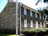
|
December 2, 1974 | Wilmington 39°46′46″N 75°32′41″W / 39.77949°N 75.54472°W |
New Castle | Built 1750 |
| 66000258 | Poplar Hall | 
|
January 20, 1961 | Dover 39°06′10″N 75°26′58″W / 39.10277°N 75.44944°W |
Kent | Built 1740, also known as the John Dickinson House. |
| 73000524 | Stonum | 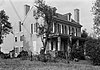
|
November 7, 1973 | New Castle 39°39′37″N 75°34′34″W / 39.66022°N 75.57602°W |
New Castle | Built 1750 |
Florida[]
| NRHP reference number | Name | Image | Date designated | Locality | County | Notes |
|---|---|---|---|---|---|---|
| 02000606 | Bannerman Plantation | 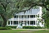
|
June 6, 2002 | Tallahassee 30°38′42″N 84°16′44″W / 30.64500°N 84.27889°W |
Leon | Built 1852 |
| 99000712 | Blackwood-Harwood Plantations | 
|
October 6, 1999 | Tallahassee 30°29′13″N 84°21′01″W / 30.48694°N 84.35027°W |
Leon | 1830s |
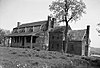
| 70000185 | Bulow Plantation Ruins | 
|
September 29, 1970 | Flagler Beach 29°26′10″N 81°08′28″W / 29.43611°N 81.14111°W |
Flagler | Built 1821, destroyed 1836 during Second Seminole War |
| 02000002 | Burn Brae Plantation-Krueger House | 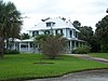
|
Stuart | Martin | ||
| 73000606 | Dunlawton Plantation and Sugar Mill | 
|
Port Orange | Volusia | ||
| 70000189 | Gamble Plantation | 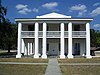
|
August 12, 1970 | Ellenton | Manatee | The house sheltered Confederate statesman Judah P. Benjamin in 1865, before he departed for England. |
| Fleming Island | Clay | House is no longer standing but the family cemetery, private chapel exist still.[4] | ||||
| 02000836 | Killearn Plantation Archeological and Historic District | 
|
Tallahassee | Leon | ||
| 70000182 | Kingsley Plantation | 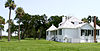
|
Jacksonville | Duval | ||
| Kinhega Lodge | 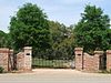
|
Tallahassee vicinity | Leon | |||
| 73000582 | Lyndhurst Plantation | 
|
Monticello | Jefferson | ||
| 04000142 | Mala Compra Plantation Archeological Site | 
|
Palm Coast | Flagler | ||
| Switzerland | St Johns | The home was destroyed during the East Florida patriot revolt in 1812.[5][4] | ||||
| Oaklawn Plantation | Tallahassee vicinity | Leon | ||||
| 72000311 | Red Bank Plantation | 
|
Jacksonville | Duval | ||
| Tallahassee vicinity | Leon | |||||
| 89000240 | Tall Timbers Plantation | Tallahassee | Leon |
Georgia[]
Hawaii[]
| NRHP reference number | Name | Image | Date designated | Locality | County | Notes |
|---|---|---|---|---|---|---|
| 93000774, 93000775, 93000777, | Kilauea Plantation |   
|
1983 | Kīlauea | Kauaʻi | Sugar cane plantation that operated from 1880 to 1971; 5 historic buildings NRHP-listed: Manager's House, Head Luna's House, Head Bookkeeper's House, Kilauea School, Kong Lung Store |
| 66000296 | Old Sugar Mill of Koloa | 
|
December 29, 1962 | Kōloa 21°54′35″N 159°28′09″W / 21.90972°N 159.46916°W |
Kauaʻi |
Kentucky[]
Louisiana[]
Maryland[]


Mississippi[]
Missouri[]
| NRHP reference number | Name | Image | Date designated | Locality | County | Notes |
|---|---|---|---|---|---|---|
| 12000563 | Hunter-Dawson Home | August 28, 2012 | New Madrid | New Madrid | ||
| 79003205 | White Haven | 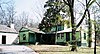
|
June 23, 1986 | Grantwood Village 38°33′04″N 90°21′07″W / 38.55111°N 90.35194°W |
St. Louis |
North Carolina[]
Oklahoma[]
| NRHP reference number | Name | Image | Date designated | Locality | County | Notes |
|---|---|---|---|---|---|---|
| 70000530 | Murrell Home | 
|
May 30, 1974 | Park Hill 35°50′50″N 94°57′51″W / 35.84735°N 94.96418°W |
Cherokee | Built in 1845 |
South Carolina[]
Tennessee[]
| NRHP reference number | Name | Image | Date designated | Locality | County | Notes |
|---|---|---|---|---|---|---|
| 05001027 | Airdrie | September 15, 2005 | Nashville | Davidson | Also known as Petway House or the Buell-King House. | |
| 89000503 | Beaver Dam Plantation | June 16, 1989 | Woodbury | Cannon | Also known as the William Cannon Houston House. | |
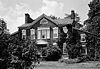
| 07001163 | Beech Grove | 
|
November 8, 2007 | Nashville | Davidson | |
| 75001741 | 1975 | Newport | Cocke | [6] | ||
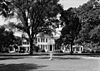
| 69000177 | Belle Meade Plantation | 
|
December 30, 1969 | Belle Meade | Davidson | |
| 73001758 | Belle Vue | 
|
October 25, 1973 | Bellevue | Davidson | |
| 75001780 | Brabson's Ferry Plantation | 
|
June 25, 1975 | Sevierville | Sevier | |
| 73001857 | Carnton |  |
January 18, 1973 | Franklin | Williamson | |
| 73001767 | Clifton Place | April 11, 1973 | Wales | Giles | ||
| 75001747 /
100003900 |
Clover Bottom Plantation | 
|
April 3, 1975 /
May 7, 2019 |
Nashville | Davidson | |
| 75001787 | Davies Manor |  |
March 19, 1975 | Memphis | Shelby | |
| 85000669 | DeVault-Massengill House | March 28, 1985 | Piney Flats | Sullivan | Also known as Mary Lou Farms. | |
| 73001823 | Elmwood | October 15, 1973 | Murfreesboro | Rutherford | ||
| 75002162 | Fairvue | 
|
Gallatin | Sumner | ||
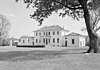
| 66000722 | The Hermitage | 
|
December 19, 1960 | Nashville 36°12′54″N 86°36′47″W / 36.21497°N 86.61297°W |
Davidson | |
| 88000363 | H. G. W. Mayberry House | 
|
April 13, 1988 | Franklin | Williamson | Constructed in 1856. Also known as Beechwood Hall. |
| 10000141 | Hall-Harding-McCampbell House | 
|
March 23, 2010 | Nashville | Davidson | |
| 75001766 | Harris-Holden House | March 19, 1975 | Howell | Lincoln | ||
| 75002162 | Isaac Franklin Plantation |
|
April 4, 2005 | Gallatin | Sumner | Also known as Fairvue. |
| 78002637 | James Bradley House | 
|
September 18, 1978 | Dixon Springs | Smith | |
| 76001766 | Kincaid-Howard House | 
|
March 16, 1976 | Fincastle | Campbell | |
| 77001269 | Lucerne | December 23, 1977 | Brownsville | Haywood | ||
| Mabry Hood House | Knox | Demolished in the 1990s. | ||||
| 78002587 | Miller House | December 8, 1978 | Elba | Fayette | ||
| 75001795 | Northcutt Plantation | 
|
May 12, 1975 | McMinnville | Warren | |
| 13000125 | Oak Hill Farm | 
|
March 27, 2013 | Stanton | Haywood and Tipton | A Tennessee Century Farm for continuous agricultural production since the 1830s. |
| 71001072 | Pinewood Mansion | Nunnelly | Hickman | Burned down in 1975.[7] | ||
| 69000180 | Ramsey House | 
|
December 23, 1969 | Knoxville | Knox | |
| 71000825 | Rattle and Snap | 
|
November 11, 1971 | Columbia 35°33′38″N 87°09′12″W / 35.56056°N 87.15333°W |
Maury | |
| 80003875 | Rhodes House | April 30, 1980 | Brighton | Tipton | ||
| 75001781 | Rose Glen | 
|
July 18, 1975 | Sevierville | Sevier | |
| 77001283 | Skipwith Hall | 
|
November 23, 1978 | Columbia | Maury | Also known as Oakwood Farm. |
| 69000179 | Travellers Rest | 
|
December 30, 1969 | Nashville | Davidson | |
| 84003641 | Walnut Grove | 
|
March 8, 1984 | Mount Pleasant | Maury | |
| 71000830 | Wessyngton | 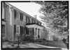
|
May 6, 1971 | Cedar Hill | Robertson | |
| 75001785 | Wheatlands | 
|
July 7, 1975 | Sevierville | Sevier | |
| 09000538 | White Plains | 
|
August 11, 2009 | Algood | Putnam | |
| 95001044 | William Washington Seay House | 
|
August 25, 1995 | Flat Rock | Wilson | |
| Robertson Island | Davidson | |||||
| Craighead House | Nashville | Davidson | Part of the Richland-West End Historic District | |||
| Burlington | 
|
Nashville | Davidson | Also known as the Elliston-Farrell House. The house was dismantled in 1932. | ||
| Ashwood Hall | Columbia | Maury | Demolished. in 1874. |
Texas[]
| NRHP reference number | Name | Image | Date designated | Locality | County | Notes |
|---|---|---|---|---|---|---|
| 83003084 | Col. Elijah Sterling Clack Robertson Plantation | 
|
April 5, 1983 | Salado | Bell | |
| 80004081 | Durazno Plantation | 
|
September 2, 1980 | Jones Creek | Brazoria | |
| 69000209 | Freeman Plantation | 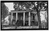
|
November 25, 1969 | Jefferson | Marion | |
| 71000971 | Hatfield Plantation | Brenham | Washington | |||
| 05000244 | Lamar–Calder House | 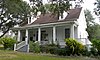
|
March 30, 2005 | Richmond | Fort Bend | |
| 71000970 | Liendo Plantation | 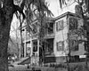
|
June 21, 1971 | Hempstead | Waller | |
| 14000104 | Monte Verdi Plantation | March 31, 2014 | Cushing | Rusk County | ||
| 75001961 | Old Brulay Plantation | October 10, 1975 | Brownsville | Cameron | ||
| 12001250 | Seward Plantation | 
|
January 29, 2013 | Independence | Washington | |
| 80004082 | Varner-Hogg Plantation | 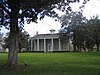
|
April 9, 1980 | West Columbia | Brazoria | |
| 77001474 | William Garrett Plantation House | 
|
March 25, 1977 | San Augustine | San Augustine | |
| Glenblythe Plantation | Gay Hill | Washington | ||||
| Hawkins Ranch | Matagorda | also known as Hawkins Plantation. | ||||
| Levi Jordan Plantation | 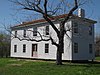
|
Brazoria | Brazoria | |||
| Peach Point Plantation | 
|
Jones Creek | Brazoria |
U.S. Virgin Islands[]
As of 1728, there were 91 plantation lots defined on Saint John, U.S. Virgin Islands. As of 1800, maps showed 68 plantations outside the villages of Cruz and Coral Bay. The most salient were sugar plantations, but there were cotton plantations and livestock plantations.[8]: 8
| NRHP reference number | Name | Image | Date designated | Locality | County | Notes |
|---|---|---|---|---|---|---|
| 81000090 | Annaberg Historic District | 
|
July 23, 1981 | Maho Bay | Saint John | Ruins of the Annaberg sugar plantation. |
| 81000089 | Brown Bay Plantation Historic District | July 23, 1981 | Brown Bay | Saint John | ||
| 78000269 | Cinnamon Bay Plantation | 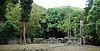
|
July 11, 1978 | Cruz Bay | Saint John | |
| 78000270 | Catherineberg Sugar Mill Ruins | 
|
March 30, 1978 | Cruz Bay | Saint John | Example of an 18th-century rum factory, and ruins of a sugar plantation. |
| 76002217 | Estate Carolina Sugar Plantation | July 19, 1976 | Coral Bay | Saint John | ||
| 78000272 | Mary Point Estate | 
|
May 22, 1978 | Mary Point | Saint John | |
| 81000094 | Coral Bay | Saint John | ||||
| 81000093 | Cinnamon Bay | Saint John | ||||
| 78002732 | Mafolie Great House | 
|
February 17, 1978 | Charlotte Amalie | Saint Thomas | Originally part of Estate Catherineberg. |
| 78000271 | Lameshur Plantation | June 23, 1978 | Cruz Bay | Saint Thomas | ||
| 76001867 | Tutu Plantation House | July 12, 1976 | Charlotte Amalie | Saint Thomas | ||
| 76001841 | Coakley Bay Estate | 
|
July 23, 1976 | Christiansted | Saint Croix | |
| 78002721 | Estate Grove Place | July 17, 1978 | Frederiksted | Saint Croix | ||
| 78002723 | Estate Hogansborg | February 17, 1978 | Frederiksted | Saint Croix | The island's first steam-powered sugar factory. | |
| 78002717 | Estate Judith's Fancy | 
|
July 17, 1978 | Christiansted | Saint Croix | |
| 80003995 | Estate Little Princess | 
|
June 9, 1980 | Christiansted | Saint Croix | |
| 86003351 | Estate Saint George Historic District | 
|
October 24, 1986 | Fredericksted | Saint Croix | |
| 76001850 | Sion Hill Estate | 
|
July 19, 1976 | Fredericksted | Saint Croix | |
| 76001858 | Whim Plantation | 
|
July 30, 1976 | Frederiksted | Saint Croix |
Virginia[]
West Virginia[]
References[]
- ^ "How to Apply the National Register Criteria for Evaluation," (PDF), National Register Bulletins, National Park Service. Retrieved March 22, 2007.
- ^ National Park Service (April 2007). "National Historic Landmarks Survey: List of National Historic Landmarks by State" (PDF). Archived from the original (PDF) on 2007-06-09. Retrieved 2007-05-20.
- ^ National Park Service. "National Historic Landmark Program: NHL Database". Archived from the original on 2004-06-06. Retrieved 2007-08-14.
- ^ a b "Hibernia Plantation History - Clay County Florida". BNSigns.com. 2014-03-17. Retrieved 2021-12-08.
- ^ Taylor, George (2010-07-23). "New Switzerland Plantation Marker, St. Johns County, FL". George Lansing Taylor Collection Main Gallery.
- ^ "National Register of Historical Places - Tennessee (TN), Cocke County". www.nationalregisterofhistoricplaces.com. Retrieved 2021-06-21.
- ^ "Photograph of Pinewood mansion". Tennessee Virtual Archive. Retrieved 2021-06-21.
- ^ Frederik C. Gjessing (August 2, 1978). "National Register of Historic Places Inventory/Nomination: Virgin Islands National Park Multiple Resource Area". National Park Service. Retrieved January 9, 2017.
Categories:
- Plantations in the United States
- Lists of buildings and structures in the United States