Llano River
| Llano River | |
|---|---|
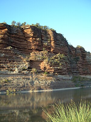 Sandstone bluffs along the Llano River, Mason County | |
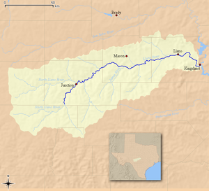 Map of the Llano River and associated watershed | |
| Location | |
| Country | United States |
| State | Texas |
| Region | Edwards Plateau |
| Physical characteristics | |
| Source | Confluence of North and South Llano |
| • location | Junction, Edwards Plateau |
| • coordinates | 30°29′33″N 099°45′22″W / 30.49250°N 99.75611°W |
| • elevation | 827 m (2,713 ft) |
| Mouth | Colorado River |
• location | Kingsland, Texas Hill Country |
• coordinates | 30°39′19″N 98°25′46″W / 30.65528°N 98.42944°WCoordinates: 30°39′19″N 98°25′46″W / 30.65528°N 98.42944°W |
• elevation | 252 m (827 ft) |
| Length | 169 km (105 mi) |

The Llano River (/ˈlænoʊ/ LAN-oh) is a tributary of the Colorado River, about 105 miles (169 km) long, in Texas in the United States.[1] It drains part of the Edwards Plateau in Texas Hill Country northwest of Austin.
Two spring-fed tributaries, the North and South Llano, stretch across the otherwise arid lands of West Texas before merging just east of the small town of Junction, in Kimble County, forming the head of the Llano River proper.[1] The Llano River runs generally east-northeast through the rolling limestone terrain of the Edwards Plateau as it flows through Kimble County and across rural Mason County, passing to the south of the town of Mason, Texas. Continuing in an easterly direction, the river carves its way through the Llano Uplift, a roughly circular geologic dome of Precambrian rock, primarily granite, located in Central Texas.[2] Flowing through Llano County, the river passes to the north of Enchanted Rock and flows through the town of Llano, Texas. Northeast of Llano, it turns sharply to the southeast, joining the Colorado from the northwest as an arm of Lake Lyndon B. Johnson, about 15 miles (24 km) southeast of Llano at Kingsland.
This river is one of the few popular fly fishing destinations in the state of Texas, and contains Guadalupe bass, the state fish of Texas. The Llano also contains largemouth bass, alligator gar, and various sunfish.[3]
The river is also associated with the legend of the Los Almagres Mine. Translated from Spanish, almagre means red ochre. In 1756, the lieutenant-general of Texas (then still a province of New Spain), Don Bernardo de Miranda, launched an expedition from San Fernando (San Antonio), to ascertain whether rumors of rich mineral deposits to the north were true. As the legend goes, Miranda came across a cave in the side of a hill in the vicinity of the Rio de las Chanas (Llano River), and reported astounding quantities of silver to be found within.[4]

See also[]
References[]
- ^ a b Llano River from the Handbook of Texas Online
- ^ Wilkes, R. "The Llano Uplift". Rob's Granite Page. Archived from the original on 2010-06-08. Retrieved 2010-04-27.
- ^ "Fly Fishing the Llano River".
- ^ Dobie, J. Frank (1978). Coronado's Children. Austin, Texas: University of Texas Press. p. 4. ISBN 978-0-292-71052-8.
- Rivers of Texas
- Tributaries of the Colorado River (Texas)
- Rivers of Kimble County, Texas
- Rivers Llano County, Texas
- Rivers of Mason County, Texas
- Texas Hill Country