Canyon Lake (Texas)
| Canyon Lake | |
|---|---|
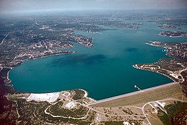 Aerial view of Canyon Lake and Dam | |
 Canyon Lake | |
| Location | Texas Hill Country, Comal County, Texas, US |
| Coordinates | 29°52′53″N 98°14′24″W / 29.88139°N 98.24000°WCoordinates: 29°52′53″N 98°14′24″W / 29.88139°N 98.24000°W |
| Type | Flood control reservoir |
| Primary inflows | Guadalupe River |
| Primary outflows | Guadalupe River |
| Basin countries | United States |
| Surface area | 8,230 acres (33.3 km2) |
| Max. depth | 134 ft (41 m) |
| Water volume | 382,000 acre⋅ft (0.471 km3) |
| Shore length1 | 80 mi (130 km) |
| Surface elevation | 909 ft (277 m) |
| References | [1] |
| 1 Shore length is not a well-defined measure. | |


Canyon Lake is a reservoir on the Guadalupe River in the Texas Hill Country in the United States. Canyon Lake is a U.S. Army Corps of Engineers reservoir formed on the Guadalupe River in Comal County by Canyon Dam, which is located about sixteen miles northwest of New Braunfels. The dam, lake, and all adjacent property are managed by the U.S. Army Corps Of Engineers. Water rights, waste water treatment, and hydroelectric generating facilities are managed by the Guadalupe-Blanco River Authority. Construction of the dam began in 1958 and was completed in 1964. The reservoir serves to provide flood control and water supply for the communities downstream from the dam. The lake is also a popular recreational destination.
Geography[]

Canyon Lake is located at 29°52′53″N 98°14′24″W / 29.88139°N 98.24000°W.[2] Please note, this GPS coordinate does not correspond to a public access location (please see the section below on Public Access in the Recreation section). It is located in northern Comal County, Texas, on the northeastern fringe of the San Antonio-New Braunfels MSA. It is about 35 mi (56 km) northeast of Downtown San Antonio and 40 mi (64 km) southwest of Austin. Towns in the immediate vicinity of the lake include Canyon City, Cranes Mill, Hancock, Fischer, Sattler, and Startzville, all part of the census-designated place known as Canyon Lake, Texas. Larger towns nearby include New Braunfels and San Marcos.

History[]
Construction of Canyon Dam began in 1958 to provide both flood control and water conservation. Impoundment of the lake began in 1964, and the lake was filled to its conservation level in 1968.
Flood protection[]
Flood protection is provided for nearly 250 square miles (647 km2) of land downstream from Canyon Dam. The canyons of the upper Guadalupe River have a capacity to carry 40,000 - 50,000 cubic feet per second (1,100 - 1,400 m³/s) ; however, the channel on the lower Guadalupe River, downstream from the Balcones Escarpment, can carry only 13,000-30,000 cubic feet per second (400 – 800 m³/s). This has led to serious flooding in the lower Guadalupe River Basin, including a major flood in New Braunfels in 1972 which was caused by heavy rains just downstream from Canyon Dam.
Canyon Dam protected downstream areas from major floods in 1978, 1987, 1991, 1992 and 1998. A record flood in July 2002 overtopped the spillway by more than seven feet (2 m) and caused significant damage below Canyon Dam.
In the 2002 flood, the peak flow was about 70,000 cubic feet per second (2,000 m³/s). The amount of water that flowed over the spillway was about 3½ times the amount of water that the reservoir holds. Erosion over the course of three days washed away soil below the spillway to reveal what is now the Canyon Lake Gorge. Water continued to flow over the spillway for six weeks.
Water conservation[]
The Guadalupe-Blanco River Authority (GBRA) has rights to the water in the conservation pool of the lake. This water is used to operate several small hydroelectric plants downstream from New Braunfels and for municipal water supply, irrigation, and industrial uses. GBRA built a hydroelectric facility at Canyon Dam in August 1987; it was put into service in February 1989.
Recreation[]

Canyon Lake is a center for recreation in the area. The Corps of Engineers built and maintains eight park areas around the lake for camping, swimming, boating and picnicking. Bank fishing is available in all park areas, and a fishing dock can be found in Cranes Mill Park on the south side of the lake. Comal County provides several public boat ramps for access to the lake. Hike, bike and equestrian trails are available, as is limited hunting (archery only) and professional fishing guide services.
PUBLIC ACCESS TO CANYON LAKE - Swimming and Boating
The GPS coordinates given for a general search of 'Canyon Lake, Texas' on Wikipedia or available from a 'Google' search do not correspond to any public access areas. The only public access to the lake is at one of the parks, marinas or boat ramps around the lake. Although the Army Corps of Engineers owns and controls the shore immediately above the lake waterfront, the remainder of the lake shore (accessible by public roads) is privately owned property and public access to the lake shore through any of these properties is not allowed.
If more information is required (maps included) please visit the Texas Parks and Wildlife website: https://tpwd.texas.gov/fishboat/fish/recreational/lakes/canyon/access.phtml the Canyon Lake Guide website: http://www.canyonlakeguide.com/ and the USACE web page: http://www.swf-wc.usace.army.mil/canyon/Maps/Ramps_ShortFormat_2012_Full_WebVersion.pdf
There are several public parks on the shores of Canyon Lake that allow access to the lake for swimming, fishing and boating.
There are 2 marinas located on the lake. The marinas have boats and jet skis available for rent.
There are several public boat ramps on the lake as well as private boat ramps. Public access boat ramps are available free of charge. The private boat ramps at the marinas or in some of the parks are available to the public for a fee. There is no fishing or swimming allowed at any of the boat ramps.
Lake level concerns[]
Plans by GBRA to sell water from Canyon Lake to supply the fast-growing San Antonio and Austin regions have raised concerns that the lake will fall well below the established conservation pool level, potentially causing problems ranging from erosion and weakening of Canyon Dam to a decline in property values and possible health issues from the exposure of long-submerged land. This has led to several administrative actions and lawsuits over the future of Canyon Lake.
References[]
- ^ Depth of Canyon Reservoir. U.S. Army Corps of Engineers.
- ^ "US Gazetteer files: 2010, 2000, and 1990". United States Census Bureau. 2011-02-12. Retrieved 2011-04-23.
External links[]
- http://mycanyonlake.com Online Community Bulletin Board and News
| Wikimedia Commons has media related to Canyon Lake (Texas). |
- Canyon Lake page at U.S. Corps of Engineers website
- Canyon Lake from the Handbook of Texas Online
- Guadalupe-Blanco River Authority
- Texas Parks and Wildlife: Canyon Lake
- Friends of Canyon Lake website
- Canyon Lake Gorge Preservation Society
- Lake Canyon Yacht Club
- Hill Country Yacht Club
- The Edwards Aquifer: Canyon Lake


| Authority control: National libraries |
|---|
- Protected areas of Comal County, Texas
- Reservoirs in Texas
- New Braunfels, Texas
- Guadalupe River (Texas)
- Bodies of water of Comal County, Texas