Los Angeles Metro Rail
 | ||
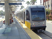
 Typical Metro Rail subway train | ||
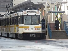
 Typical Metro Rail light rail train | ||
| Overview | ||
|---|---|---|
| Area served | Los Angeles County, California | |
| Transit type | Rapid transit/light rail | |
| Number of lines |
| |
| Number of stations | 93 | |
| Daily ridership | 344,176 (2018; avg. weekday boardings) | |
| Annual ridership | 108,017,525 (2018) | |
| Website | www | |
| Operation | ||
| Began operation | July 14, 1990 | |
| Operator(s) | Los Angeles County Metropolitan Transportation Authority (Metro) | |
| Headway | 4–8 mins (peak); 10–20 mins (off-peak) | |
| Technical | ||
| System length | 97.6 mi (157.1 km)[1] | |
| Track gauge | 4 ft 8+1⁄2 in (1,435 mm) standard gauge | |
| Electrification | 750 V DC | |
| ||

The Los Angeles Metro Rail is an urban rail transportation system serving Los Angeles County, California, United States. It consists of six lines, including two subway (heavy rail rapid transit) lines (the B and D lines) and four light rail lines (the A, C, L and E lines) serving 93 stations. It connects with the Metro Busway bus rapid transit system (the G and J lines) and also with the Metrolink commuter rail system.
Metro Rail is owned and operated by the Los Angeles County Metropolitan Transportation Authority (Metro) and started service in 1990. It has been extended significantly since that time and several further extensions are either in the works or being considered. The system served a ridership of 344,176 on an average weekday in 2018.
Los Angeles had two previous rail transit systems, the Pacific Electric Red Car and Los Angeles Railway Yellow Car lines, which operated between the late 19th century and the 1960s. The Metro Rail system utilizes many of their former rights-of-way, and thus can be considered their indirect successor.
Current system[]
Lines[]
In Los Angeles Metro terminology, common with most other metro systems, a line is a named service, defined by a route and set of stations served by trains on that route. (The word does not refer to a physical rail corridor, as it does in New York City Subway nomenclature.)
Metro also uses the same line letter naming system for its Metro Busway services (which are bus rapid transit routes operating in transitways).
Six Metro Rail lines operate in Los Angeles County:[1]
| Line name | Opening | Last extension | Length | Stations | Termini | Type |
|---|---|---|---|---|---|---|
| 1990 | 1991 | 21.3 mi (34.3 km) | 22 | 7th Street/Metro Center (north) Downtown Long Beach (south) |
Light rail | |
| 1993 | 2000 | 16.4 mi (26.4 km)[2] | 14 | North Hollywood (north) Union Station (south) |
Subway | |
| 1995 | — | 19.5 mi (31.4 km) | 14 | Redondo Beach (west) Norwalk (east) |
Light rail | |
| 2006[a] | — | 6.4 mi (10.3 km)[2] | 8 | Wilshire/Western (west) Union Station (east) |
Subway | |
| 2012 | 2016 | 13.1 mi (21.1 km) | 19 | 7th Street/Metro Center (east) Santa Monica (west) |
Light rail | |
| 2003 | 2016 | 29.7 mi (47.8 km) | 27 | APU/Citrus College (north) Atlantic (south) |
Light rail |
- ^ The segments on which the D Line operates opened as part of the B Line in 1993 and 1996. The D Line was not defined as a distinct line until 2006.
The B and D lines follow a fully underground route (subway), and the C Line follows a fully grade separated route. The A, E and L Line routes run in a mix of environments, including at-grade street running, at-grade in an exclusive corridor, elevated, and underground.[1] The K Line is expected to open in 2021.
The two subway lines (B and D) share tracks between Union Station and Wilshire/Vermont, while two of the light-rail lines (A and E) share tracks between 7th St/Metro Center and Pico. Future system expansions are expected to use more shared light-rail tracks.
Stations[]


The large majority of light rail stations are either at ground level or elevated, with a handful underground. All subway stations are underground. Future light rail lines will add more underground stations to the system.
Stations include at least two ticket vending machines, wayfinding maps, electronic message displays, and bench seating. Each station features unique artwork reflecting local culture and/or the function of transit in society.
Stations are unstaffed during regular hours. Call boxes are available at stations to allow employees at the Metro Rail Operations Control Center to assist passengers with concerns.
Metro Rail uses a proof-of-payment fare system, with Metro's fare inspectors randomly inspecting trains and stations to ensure passengers have a valid fare product on their Transit Access Pass (TAP) electronic fare card. When passengers enter a station, they encounter TAP card validators which collect fares when a customer places their card on top. Additionally, fare gates (turnstiles) connected to TAP card validators are at all underground stations, all elevated stations and some surface stations. Once passengers pass these validators or board a train, they have entered the "fare paid zone," where fare inspectors may check their TAP card to ensure they have a valid fare.
Underground stations are typically large in size with a mezzanine level for fare sales and collection above a platform level where passengers board trains.
Street-level stations are typically simpler with platforms designed with shade canopies, separated from nearby roads and sidewalks, where passengers can purchase fares and board a train.
Subway stations and tunnels are designed to resist ground shaking that could occur at a specific location, but there is no general magnitude of earthquake that the entire system is expected to withstand.[3] The Metro Rail system has not suffered any damage due to earthquakes since its opening in 1993.
Some suburban stations have free or paid park and ride lots available and most have bike storage available.
Rolling stock[]
Metro Rail maintains two distinct systems of rail: a light rail system and a subway system, which use incompatible technologies, even though they both use 4 ft 8+1⁄2 in (1,435 mm) standard gauge. Metro's subway lines are powered by third rail, whereas its light rail lines are powered by overhead catenary. Also, the two separate systems have different loading gauge, and platforms are designed to match the separate car widths.
Hours of operation[]
Between the system's opening in 1990 and February 2020, Metro Rail lines ran regularly between 5:00 am and midnight, seven days a week. Limited service on particular segments was provided after midnight and before 5:00 am. On Friday and Saturday evenings, service operated until approximately 2:00 am. There was no rail service between 2:00 am and 3:30 am, except on special occasions such as New Year's Eve. Service operated every 5–10 minutes during the peak period, every 10–15 minutes during middays and during the day on weekends, and every 20 minutes during the evening until the close of service. Exact times varied from route to route.
In March 2020, the system started to adjust train frequencies in order to accommodate for restrictions that were enacted in the wake of the COVID-19 pandemic. Trains would continue to run between 5:00 am and midnight daily, with late night weekend service being removed in order to accommodate for train cleaning.
Fares and fare collection[]
The standard Metro base fare applies for all trips. Fare collection is based on a partial proof-of-payment system. At least two fare machines are at each station. Fare inspectors, local police and deputy sheriffs police the system and cite individuals without fares. Passengers are required to purchase a TAP card to enter stations equipped with fare gates. Passengers using a TAP card can transfer between Metro routes for free within 2 hours from the first tap.
The following table shows Metro fares, effective May 15, 2018 (in US dollars):
| Fare type | Regular | Senior (62+) Disabled Medicare |
College Vocational |
Student K-12 |
|---|---|---|---|---|
| Base fare | $1.75 | $0.35 (off-peak) $0.75 (peak) |
— | $1 |
| 1-Day Pass | $7 | $2.50 | — | — |
| 7-Day Pass | $25 | — | — | — |
| 30-Day Pass | $100 | $20 | $43 | $24 |
| Metro-to-Muni Transfer | $0.50 | $0.25 | — | — |
Transit Access Pass (TAP) and fare gates[]
Metro has implemented a system of electronic fare collection using a stored value smartcard called the Transit Access Pass (or TAP Card). This card was intended to simplify fare collection and reduce costs.[4] In 2012, paper monthly passes were phased out and replaced with the TAP Card. As of September 2013, first-time Metro riders must deposit an additional $2 (or $1 at TAP vending machines) on top of their first fare payment to obtain a reloadable TAP Card. In addition, Metro began installing fare gates in 2008 all underground stations, all elevated stations and some surface stations. Implementation of both programs (the TAP Card and the fare gate program) has turned out to be expensive ($154 million in total, so far) and its initial rollout was problematic.[5]
Ridership[]
The Metro Rail system saw a total ridership of 108,017,525 in 2018.[6]
As of the second quarter of 2018, the combined Metro B and D lines averaged a weekday ridership of 135,400, making it the ninth busiest rapid transit system in the United States.[7] Taking overall track length into consideration, Metro Rail's subway lines transport 7,960 passengers per route mile, making this the fifth busiest system U.S. rapid transit system on a per mile basis.
Metro's light rail system is the busiest in the United States with 203,300 average weekday boardings during the second quarter of 2018.[7] At 83.6 miles (134.5 km)[8] Metro's light rail system is the second largest in the United States.
Security and safety[]
Half of the Metro Rail's trains and stations are patrolled by the Los Angeles County Sheriff's Department, under a law enforcement contract. The Los Angeles Police Department, and Long Beach Police Department, also patrol stations within their respective cities, also under contract.[9] The system is also monitored by security personnel by closed-circuit television cameras in Metro Rail stations and subway cars.[10]
History[]
In the early 20th century, Southern California had an extensive privately owned rail transit network with over 1,000 miles (1,600 km) of track, operated by Pacific Electric (Red Cars) and Los Angeles Railway (Yellow Cars).[11] However, from 1927 revenue shortfall caused Pacific Electric to begin replacing lightly used rail lines with buses. In 1958 the remnants of the privately owned rail and bus systems were consolidated into a government agency known as the Los Angeles Metropolitan Transit Authority or MTA. By 1963 the remaining rail lines were completely removed and replaced with bus service.
In the following decades, growing traffic congestion led to increased public support for rail transit's return. Beginning in the 1970s, a variety of factors, including environmental concerns, an increasing population and the price of gasoline led to calls for mass transit other than buses. The Los Angeles County Metropolitan Transportation Authority (LACMTA, now branded as Metro) began construction of the initial lines throughout the 1980s using revenues from a voter-approved increase in sales tax. The Blue (A) Line finally opened on July 14, 1990, some 27 years after the final streetcar line closed. Since that date, the system has been developed to its current size. The following table shows this expansion's timeline:
| Segment description | Date opened | Current line(s) operating on segment |
Endpoints | # of new stations |
Length (miles) |
|---|---|---|---|---|---|
| Blue Line Initial Segment | July 14, 1990 | Pico to Anaheim Street | 17 | 19.1 | |
| Blue Line Long Beach Loop | September 1, 1990 | Anaheim Street to Pacific | 4 | 2.2 | |
| Blue Line To Financial District | February 15, 1991 | Pico to 7th St/Metro Center | 1 | 0.7 | |
| Red Line MOS-1 | January 30, 1993 | Union Station to Westlake/MacArthur Park | 3[a] | 4.4 | |
| Green Line | August 12, 1995 | Redondo Beach to Norwalk | 13[a] | 20.0 | |
| Red Line MOS-2 West | July 13, 1996 | Westlake/MacArthur Park to Wilshire/Western | 3 | 2.0 | |
| Red Line MOS-2 North | June 12, 1999 | Wilshire/Vermont to Hollywood/Vine | 5 | 4.7 | |
| Red Line MOS-3 | June 24, 2000 | Hollywood/Vine to North Hollywood | 3 | 6.3 | |
| Gold Line Initial Segment | July 26, 2003 | Union Station to Sierra Madre Villa | 12[a] | 13.7 | |
| Gold Line Eastside Extension | November 15, 2009 | Union Station to Atlantic | 8 | 6.0 | |
| Expo Line Phase 1 | April 28, 2012 | Flower/Washington Intersection to La Cienega/Jefferson[b] | 8 | 7.6 | |
| Expo Line To Culver City | June 20, 2012 | La Cienega/Jefferson to Culver City | 2[c] | 1.0 | |
| Gold Line Foothill Extension | March 5, 2016[12] | Sierra Madre Villa to APU/Citrus College | 6[12] | 11.5[12] | |
| Expo Line Phase 2 | May 20, 2016[13] | Culver City to Santa Monica | 7[13] | 6.6[13] | |
| TOTAL | 93 | 105.8[d] | |||
- ^ Jump up to: a b c Segment also included significant expansion of an existing station(s): this was not counted as a new station.
- ^ In terms of added trackage; Expo Line has thru service to 7th St/ Metro Center.
- ^ Expansion included new infill station.
- ^ Likely varies from the "official" Metro figure due to rounding differences.
Planned expansion[]
Metro has worked to plan and prioritize project funding and implementation. Metro's 2009 Long Range Transportation Plan (LRTP) was developed to provide a long-term vision of transportation system development for the next 30 years.[14] Metro worked to update the 2009 LRTP plan citing new housing trends and fiscal changes. Metro released the updated LRTP in 2020.[15]
Beginning in 2014, Metro saw its ridership numbers begin to decline. Many explanations exist for the decline, including safety concerns, an increase in ride-hailing service usage, low-income housing opportunities drying up in L.A. because of the increase in rents, and a shortage of housing.[16] Ridership declines also coincide with passage of AB 60, signed into law by Governor Brown in 2013, which provides for issuance of a vehicle operators license regardless of immigration status.[17][18]
The fiscal changes are the passage of Measure R, a countywide incrememental sales tax increase passed by voters in 2008, provides funding for many of the highest priority projects in the LRTP.[19][non-primary source needed] On November 6, 2012, Metro attempted to pass Measure J,[20] but failed as it did not reach the two-thirds majority needed to pass.[21][22] In November 2016 election, Metro decided to place another sales tax on the ballot. The voters then approved Measure M, a half-cent permanent sales tax increase, to fund many local projects, including Metro Rail expansion.[23]
In 2018, Metro approved renaming its rail lines using a letter-based scheme, similar to those in New York City.[24][25] Metro recommended the opening of the refurbished A Line in 2019 as a starting point to rename the lines,[26] and then continuing with the opening of the K line, finishing in time for the opening of the Regional Connector in 2022.[27][non-primary source needed]
Current and priority projects[]
The following rail projects have been given high priority by Metro. They all appear in the 2009 LRTP constrained plan,[14] and all have funding earmarked from Measure R.[19][28] With the passage of Measure M in 2016, Metro released an updated Long Range Transportation plan in February 2017, and released a full report in 2020,[29] along with its Twenty-eight by '28 initiative.[30]
| Concept name | Description | Construction | Operational | Status | Ref. |
|---|---|---|---|---|---|
| Constructs a new light rail route starting at an underground station at the current Crenshaw/Expo station on the E Line at Crenshaw Blvd and running south to connect to the C Line near the current Aviation/LAX station. | 2014–2020 | 2022 | Under construction | [31] | |
| Creates a new light rail tunnel through Downtown Los Angeles linking the A, L and E Lines. | 2015–2022 | Mid 2022 | Under construction | [32][33][34] | |
| Phase 1 extending the D Line west along Wilshire Blvd to La Cienega, Phase 2 extending a further three miles from La Cienega thru Beverly Hills to Century City. Phase 3 will consist of two additional stations—in Westwood near UCLA, and at the West Los Angeles VA Medical Center. All currently under construction with plans to finish all three phases in time for the 2028 Summer Olympics, which the city will host. UCLA will be site of the Olympic Village. | 2015–2026 | 2023 (Phase 1) / 2025 (Phase 2) / 2027 (Phase 3) | Under construction | [35][36][37][38] | |
| LAX Automated People Mover | Will connect LAX terminals and a new rental car facility to the Metro Rail system through the construction of an automated people mover system and an infill light rail station, Aviation/96th Street station, which will be served by the K and C Lines. Built in cooperation with Los Angeles World Airports (LAWA). | 2018–2023 | 2023 | Under construction | [39][40][41] |
| Further extends the northeast segment of the current LRT L Line (which will be operated as part of the A Line by the time this extension opens) eastward from APU/Citrus College station in Azusa to Pomona. Phase 2B (Part 2) from Pomona to Montclair is still attaining funding. | 2019–2025 | 2025 | Under construction | [42][43][44][45] | |
| East San Fernando Light Rail Transit Project | LRT line connecting the east San Fernando Valley to the G Line, largely along Van Nuys Blvd and San Fernando Road. The HRT Sepulveda Pass Transit Corridor is immediately south of Van Nuys Blvd corridors terminus. A transfer station will be constructed to connect with three possible transit options: the BRT G Line, HRT Sepulveda pass Transit Corridor Line and the planned LRT. Transfer station optioned include the Metrolink Van Nuys station, a Sherman Way station or the G Line Van Nuys station. LRT and HRT are not compatible as a single route. | 2022 | 2028 | Final EIR/CEQA in progress | [46][47][48] |
| Extends the LRT L Line (future E Line) from its current East LA terminus eastward along Washington Boulevard to Whittier. | 2025 | 2035 | Final EIR/CEQA in progress | [49][50] | |
| Extends the LRT C Line from its current terminus in Redondo Beach towards Torrance and South Bay cities. If accelerated and funds are available, by 2028. | 2026 | By 2033[51] | Two 's optioned / Draft EIR in progress | [52] | |
| West Santa Ana Branch Transit Corridor | Creates a new LRT route connecting downtown LA to Artesia and the Gateway Cities, much of it along the West Santa Ana Branch, a disused Pacific Electric right-of-way. The downtown terminus is still undetermined; possibilities include the Arts District, and Union Station. | 2022 | 2028[53] | Two 's optioned/ Draft EIR in progress | [54][55][56] |
| Sepulveda Pass Transit Corridor Phase 1 and 2 | Planning underway on a rail connection between the G Line and the East San Fernando Valley Transit Corridor (see above) in the Valley to the D and E Lines on the Westside. Modes under consideration including a standalone HRT subway; or a monorail, which unlike the other modes could traverse the Sepulveda Pass without tunneling. Existing local funding sources will provide approximately $5.7 billion for the project for a scheduled opening in the early 2030s; additional funds, including from public-private partnerships, are being sought to complete the line before the 2028 Summer Olympics. | 2028 | 2039 | Four 's analysis in progress / Draft EIR in progress | [57][58] |
| Create a new LRT subway line connecting the B Line's Hollywood/Highland station south to the D Line, and the K Line's Expo/Crenshaw Station via Santa Monica Boulevard in West Hollywood. Possible north–south routes including Fairfax, La Brea, and San Vicente Boulevard. An extension north of the K Line is included as a Tier 1 Strategic Unfunded Plan project in the 2009 Long Range Transportation Plan. The city council approved in May 2018, to expedite its own environmental study to speed up the approval process with Metro. Metro's 2018 budget included $500,000 to begin the draft environmental studies for the extension project. Local residents created the West Hollywood Advocates for Metro Rail to advocate a new LRT or HRT. West Hollywood has publicly stated they prefer all routes be underground thru Santa Monica boulevard. | 2041 | 2047 | Three 's analysis in progress / Draft EIR in progress | [14][59][60][61][62] | |
| Added due to public comments. Extend the HRT D and B Lines from their eastern terminus at Union Station, south along the L.A. River to the Arts District, and possibly across the river along Whittier Blvd. to the Eastside. Not included in 2009 Long Range Transportation Plan. However, Metro is studying the possibility of adding one or two stops along the river in the Arts District as part of a project to improve and expand the rail yard already in the area to accommodate increased headways once the D Line extension west is completed. Draft Environmental study funds were appropriated in the 2018 Metro budget. Draft EIR in progress. Metro advocates no Measure M or R funds are available for construction. | Unknown | Unknown | Draft EIR in progress | [63][64][65][66] | |
| Vermont Transit Corridor | Create a new north–south subway route down Vermont Avenue extending the HRT B Line at the Wilshire/Vermont Station south, to the Metro E Line and C Line. Included as a Tier 2 Strategic Unfunded Plan project in 2009 Long Range Transportation Plan; a Bus rapid transit line has been funded in the near term by Measure M, but studies will be conducted for possible heavy rail rapid transit, as the Vermont corridor is Metro's second busiest public transportation corridor. | BRT 2020; HRT 2060 | BRT 2024; HRT 2067 | Three analysis funded / Pending Draft EIR for BRT | [14][67] |
| Converting the current G Line Bus Rapid Transit route into LRT. Made possible after the 2014 repeal of state legislation prohibiting LRT along the G Line right of way, which had been enacted due to neighborhood opposition in the 1990s. Bridges along the busway are designed to LRT standards, but the project would require substantial service disruption as the roadway is replaced by rails and catenary wire installed. Some Valley politicians and pressure groups have endorsed the proposal; critics have suggested funding would be better spent on adding new lines along other corridors in the Valley. Long terms plans include complete conversion in phases with full replacement by 2057. Metro commenced BRT upgrades in 2018 by adding more grade crossing gates, two new over cross bridges at Van Nuys Blvd and Sepulveda Blvd, reducing travel time by 20%. | 2051 | 2057 | No current funds available for LRT until 2051 | [68][69][70] | |
| Extend the LRT C Line from LAX northwest to Venice and Santa Monica Beach and possibly connect with the E Lines western terminus. The C Line was originally engineered to maintain compatibility with this extension. Included in City of Los Angeles Westside Mobility Plan, and as a Tier 2 Strategic Unfunded Plan project in 2009 Long Range Transportation Plan. | BRT 2043; LRT Unknown | BRT 2047; LRT Unknown | No LPA or EIR conducted | [14][71] |
Other expansion concepts[]
Metro's Long Range Transportation Plan was published in 2009,[14] and was updated by in 2020.[15] The following proposed line/system expansions do not have funding or high priority in Metro's long-range plans. Some are listed as "strategic unfunded" in the last Long Range Transportation Plan, indicating some possibility they could be constructed should additional funding materialize. Others have been the subject of Metro Board discussion, with the possibility of future feasibility studies. (More information on each project can be found in the references.)
| Concept name | Description | Source |
|---|---|---|
| Burbank–Glendale Line | Would connect Downtown Los Angeles to Glendale and Burbank. Studied in the 1990s, and included as a Tier 1 Strategic Unfunded Plan project in 2009 Long Range Transportation Plan.[14] | [72][14] |
| B Line To Burbank Airport | Extend the Metro B Line 3.2 miles (5.1 km) from its northwestern terminus to Burbank Airport. Included as a Tier 1 Strategic Unfunded Plan project in 2009 Long Range Transportation Plan.[14] | [14] |
| C Line To Norwalk Metrolink | Extend the C Line east to Norwalk/Santa Fe Springs station (Metrolink). Included as a Tier 1 Strategic Unfunded Plan project in 2009 Long Range Transportation Plan,[14] but is included among the Major Transit Projects (Figure 8) in the 2020 Long Range Transportation Plan with an estimated "open year" of 2052.[15] | [73] |
| "Pink Line"/"Silver Line" (former names) | DTLA Union Station thru Hollywood to Beverly Hills terminating at the under construction D Line Century City Station. Stops in or near Silver Lake, Dodger Stadium, Echo Park, West Hollywood and Century City. Mostly a Sunset Boulevard and Santa Monica Boulevard east–west route. Possibly using the already built HRT B Line tracks thru Hollywood or the LRT K Line under consideration in West Hollywood. East of Union Station would head to the City of La Puente or El Monte, CA. With possible stops in East L.A., Cal State LA, San Gabriel and Baldwin Park. No LPAs listed. No funds available. Listed as one of several "Strategic Unfunded Plan" project in the 2009 Long Range Transportation Plan, Tier 2.[14] Eastside route no longer met by the removed Eastside Transit Corridor option along The 60 Freeway. | [74][75][76][14] |
| Harbor Line | Light rail line to connect harbor area (San Pedro) to Metro A Line or C Line. Floated in LA City Council motions and Metro Harbor Subdivision studies. Also, a further southward extension of the C Line is included as a Tier 1 Strategic Unfunded Plan project in the 2009 Long Range Transportation Plan. Other plans could lead to the J Line being converted to rail.[14] | [77] |
| D Line Extension Phase 4 | Extend the Metro D Line 3.5 miles (5.6 km) from its under construction western terminus, Westwood/VA Hospital station to Downtown Santa Monica station. No funds available. | [78][79] |
| Restore the Venice Boulevard right of way train service from Venice Beach in the west to Culver Junction area possibly heading north on La Brea Avenue to Hollywood or east into Downtown Los Angeles. Would service the westside and Central Los Angeles. Pacific Electric Venice Short Line was last used in 1950's. | [80] |
See also[]
- Los Angeles County Metropolitan Transportation Authority
- Los Angeles Metro Rail rolling stock
- Breda A-650 Metro Red Line Railcar
- Transportation in Los Angeles
- Measure R
- List of metro systems
- List of tram and light rail transit systems
- List of United States rapid transit systems by ridership
- List of United States light rail systems by ridership
References[]
- ^ Jump up to: a b c "Facts At A Glance". Metro. June 24, 2018. Retrieved March 23, 2021.
- ^ Jump up to: a b "Regional Connector Transit Corridor Project Contract No. E0119 – Operations and Maintenance Plan (Final)" (PDF). 2.1 Metro Light Rail Overview. Los Angeles County Metropolitan Transit Authority. September 10, 2013. pp. 2–1. Retrieved May 19, 2017.
- ^ Hymon, Steve (August 10, 2012). "Designing a subway to withstand an earthquake". The Source. Retrieved February 25, 2019.
- ^ "Fares". Metro. Retrieved September 30, 2010.
- ^ "MTA's $46M system of locking turnstiles sits unused, waiting for fare cards to be adopted - LA Daily News". Dailynews.com. August 21, 2010. Archived from the original on August 25, 2010. Retrieved September 30, 2010.
- ^ "Interactive Estimated Ridership Stats". Metro. Los Angeles Country Metropolitan Transportation Authority. Retrieved February 11, 2018.
- ^ Jump up to: a b "Public Transportation Ridership Report Second Quarter 2018" (PDF). American Public Transportation Association (APTA). August 24, 2018. Archived from the original (PDF) on October 4, 2018. Retrieved January 17, 2019 – via http://www.apta.com/resources/statistics/Pages/ridershipreport.aspx.
- ^ "Metro – Facts at a Glance". Los Angeles County Metropolitan Transportation Authority (Metro). June 24, 2018. Retrieved January 17, 2019.
- ^ "LAPD Officers to Patrol Metro Buses, Trains in the City of Los Angeles". lamayor.org. February 23, 2017.
- ^ "Riders with Other Forms of Transport Switching to Metro". www.metro.net. September 13, 2006. Retrieved May 15, 2013.
- ^ Taplin, Michael (1991). "City of the Automobile: Los Angeles looks to Light Rail London". Light Rail Review 2. Platform 5 Publishing/Light Rail Transit Association. pp. 27–30. ISBN 1-872524-23-0.
- ^ Jump up to: a b c Nelson, Laura (March 5, 2016). "San Gabriel commuters cheer as Gold Line rail extension officially opens". Los Angeles Times. Retrieved March 6, 2016.
- ^ Jump up to: a b c Hymon, Steve (February 25, 2016). "17 things to know about Expo 2 opening on May 20". The Source. Metro. Retrieved May 21, 2016.
- ^ Jump up to: a b c d e f g h i j k l m n "2009 Long Range Transportation Plan" (PDF). Los Angeles County Metropolitan Transportation Authority (Metro). 2010. p. 31. Retrieved January 9, 2016.
- ^ Jump up to: a b c 2020 Long Range Transportation Plan (PDF) (Report). Metro. 2020. Retrieved March 13, 2021.
- ^ Chiland, Elijah (May 22, 2019). "Is Metro ridership down because low-income passengers are leaving LA?". Curbed LA. Retrieved May 23, 2019.
- ^ "AB 60 Driver Licenses". California Department of Motor Vehicles.
- ^ "L.A. Metro Ridership". Propel L.A.
- ^ Jump up to: a b "Measure R". Metro. Retrieved September 30, 2010.
- ^ "Measure J". Metro. Archived from the original on October 12, 2012. Retrieved October 21, 2012.
- ^ "Measure J Fails". County of Los Angeles Registrar-Recorder. Archived from the original on January 14, 2013. Retrieved January 12, 2013.
- ^ "Transit Backers Seek to Change State Law". Los Angeles Times. December 4, 2012. Retrieved January 12, 2013.
- ^ Nelson, Laura J. (June 23, 2016). "Metro puts half-cent sales tax increase for transportation projects on November ballot". Los Angeles Times. Retrieved October 4, 2016.
- ^ Hymon, Steve (April 7, 2015). "PowerPoint: Metro staffs proposal to rename rail and BRT lines". The Source. Metro.
- ^ "LA Metro Could Switch Rail Line Names From Colors To Letters". Curbed Los Angeles. Curbed Staff. April 3, 2015.
- ^ "More intersection, road closures for Blue Line upgrades". Long Beach Post.
- ^ "Plan 2018-0684 - Metro Board". Boardagendas.metro.net. November 15, 2018. Retrieved February 15, 2020.
- ^ "Transit Program - Project Management - Project Budget and Schedule Status" (PDF). Metro. June 19, 2014. Retrieved August 16, 2014.
- ^ "Long Range Transportation Plan". Metro.net. Retrieved February 15, 2020.
- ^ "Twenty-Eight by '28 Initiative". Metro.net. Retrieved March 19, 2021.
- ^ "Crenshaw Line Opening Pushed Back to Late 2021 – Nearly a Year Later than the Date Projected Six Months Ago". LA Streetsblog. Retrieved April 10, 2020.
- ^ "Regional Connector Transit Corridor". Metro. May 20, 2014. Retrieved July 27, 2014.
- ^ Hymon, Steve (September 30, 2014). "Ground is broken for Regional Connector project to link Blue, Expo and Gold Lines". The Source. Metro. Retrieved November 19, 2014.
- ^ "L.A. Metro's downtown subway project may not open until mid-2022". Los Angeles Times. May 12, 2019.
- ^ "Purple Line Extension (project website)". Metro. February 11, 2014. Retrieved July 29, 2014.
- ^ "Summer 2013 - General Fact Sheet - Purple Line Extension" (PDF). Metro. Retrieved July 25, 2013.
- ^ Notice to proceed issued for section 2 of the Purple Line Extension, the source.metro.net, 2017/04/27.
- ^ Sotero, Dave (November 10, 2014). "Long wait over: groundbreaking held for Wilshire Boulevard subway extension". The Source. Metro. Retrieved November 19, 2014.
- ^ "Airport Metro Connector". Metro. Retrieved November 19, 2014.
- ^ "City Council approves long-awaited people mover to LAX". Los Angeles Times. April 11, 2018. Archived from the original on April 12, 2018. Retrieved April 12, 2018.
- ^ GmbH, finanzen net. "Fluor Announces Financial Close on Los Angeles International Airport Automated People Mover". markets.businessinsider.com.
- ^ Newton, Damien. "Foothill Gold Line to Pomona Is Officially Under Construction – Streetsblog Los Angeles". La.streetsblog.org. Retrieved February 15, 2020.
- ^ Pacheco, Antonio (June 28, 2017). "L.A. pushes ahead with $1.4 billion Gold Line extension". Archpaper.com. Retrieved February 15, 2020.
- ^ Márquez, Liset. "There's now enough money to build the Gold Line through to Montclair – Daily Bulletin". Dailybulletin.com. Retrieved February 15, 2020.
- ^ "Metro approves $1.4B construction plan for Gold Line extension to Claremont - Curbed LA". La.curbed.com. June 23, 2017. Retrieved February 15, 2020.
- ^ "East San Fernando Valley Transit Corridor". Metro. July 8, 2014. Retrieved August 16, 2014.
- ^ "The Valley will get light rail: Metro board approves north-south line along Van Nuys Boulevard". Los Angeles Times. June 28, 2018.
- ^ Sotero, Dave (December 3, 2020). "Metro Board approves Final EIR for East San Fernando Valley Light Rail Transit Project". The Source. Metro.
- ^ "Eastside Transit Corridor Phase 2". Metro. May 6, 2014. Retrieved August 16, 2014.
- ^ "Metro staff provides update on Eastside Gold Line - The Source". Thesource.metro.net. February 6, 2020. Retrieved February 15, 2020.
- ^ "Green Line Extension to Torrance Fact Sheet" (PDF). Metro. March 2019.
- ^ "South Bay Metro Green Line Extension". Metro. March 24, 2014. Retrieved August 16, 2014.
- ^ Sharp, Steven (November 27, 2017). "Here are the 28 Projects that Metro Could Complete Before the 2028 Olympics". Urbanize LA. Retrieved February 15, 2020.
- ^ "West Santa Ana Transit Corridor". Metro. Retrieved June 12, 2018.
- ^ "Home". pacificelectriccorridor.com. Retrieved September 30, 2010.
- ^ https://media.metro.net/projects_studies/westSantaAnaBranch/images/NorthernAlignmentOptionsReport_WSAB_2017-04.pdf
- ^ "Sepulveda Pass Corridor". Metro. Retrieved August 16, 2014.
- ^ "Rail concepts released for Sepulveda Transit Corridor project - The Source". Thesource.metro.net. June 7, 2018. Retrieved February 15, 2020.
- ^ "WHAM – West Hollywood Advocates for Metro Rail". Whamrail.com. Retrieved February 15, 2020.
- ^ Sharp, Steven (July 23, 2018). "Five Options Under Consideration for the Crenshaw/LAX Line's Northern Extension". Urbanize LA. Retrieved February 15, 2020.
- ^ "Actions taken by Metro Board today - The Source". Thesource.metro.net. May 24, 2018. Retrieved February 15, 2020.
- ^ Hymon, Steve (August 17, 2020). "Three routes recommended for further study on Crenshaw Northern Extension project". The Source. Metro.
- ^ "Los Angeles Downtown News and Information". Ladowntownnews.com. May 27, 2010. Retrieved September 30, 2010.
- ^ Nelson, Laura J. (March 18, 2015). "Metro could expand subway service to the downtown L.A. Arts District". Los Angeles Times. Retrieved May 28, 2015.
- ^ "Metro Board considers item for formal study of Arts District Station - The Source". Thesource.metro.net. June 20, 2018. Retrieved February 15, 2020.
- ^ Hymon, Steve (March 30, 2021). "Scoping meetings in April for upcoming Arts District Station environmental report". The Source. LACMTA. Retrieved March 30, 2021.
- ^ "A subway on Vermont? Metro is considering it - Curbed LA". La.curbed.com. May 7, 2018. Retrieved February 15, 2020.
- ^ Hymon, Steve (July 9, 2014). "Transportation headlines, Wednesday, July 9". The Source. Metro. Retrieved January 19, 2016.
- ^ Olga, Grigoryants (July 17, 2018). "LA's Metro says improvements are in the works for the Orange Line, with light rail in mind". Los Angeles Daily News. Retrieved July 17, 2018.
- ^ "Metro breaks ground on Orange Line Improvements Project - The Source". Thesource.metro.net. October 12, 2018. Retrieved February 15, 2020.
- ^ "Measure M project descriptions - The Source". Thesource.metro.net. November 8, 2016. Retrieved February 15, 2020.
- ^ BURBANK-GLENDALE-LOS ANGELES RAIL TRANSIT PROJECT (PDF) (Report). Metro. 1992. Retrieved August 24, 2020.
- ^ Weikel, Dan (January 10, 2016). "Closing 2.8-mile transit gap in Norwalk could smooth regional commute". Los Angeles Times. Retrieved January 19, 2016.
- ^ "Metro Silver Line - Los Angeles Light Rail Trains from El Monte to Silver Lake // Silverline, Mass Transit". metrosilverline.com. Archived from the original on October 29, 2005.
- ^ "The National Transit Coalition". thetransitcoalition.us. Archived from the original on February 16, 2009. Retrieved May 21, 2007.
- ^ Freemark, Yonah (October 18, 2010). "Realizing the Impossible: Los Angeles' Subway Extension « The Transport Politic". Thetransportpolitic.com. Retrieved February 15, 2020.
- ^ "harborline". harborline.blogspot.com.
- ^ "Does L.A. Need the Santa Monica Purple Line Extension?". Urbanize LA. January 31, 2017.
- ^ "L.A.'s not-quite 'subway to the sea' finally breaks ground". Los Angeles Times. November 8, 2014.
- ^ "Who Are We Building Transit For?". LA Streetsblog. January 9, 2020.
External links[]
![]() Media related to LACMTA Metro Rail at Wikimedia Commons
Media related to LACMTA Metro Rail at Wikimedia Commons
Route map:

| ( • help)
|
- History of the Metro Rail System
- Network map (to-scale)
- Google map of Metro Rail/Busway stations
- Go Metro - Rail Map
- Image of the underground construction of Metro Rail system in Los Angeles, California, 1989. Los Angeles Times Photographic Archive (Collection 1429). UCLA Library Special Collections, Charles E. Young Research Library, University of California, Los Angeles.
| show |
|---|

| show |
|---|
| show Authority control |
|---|
- Los Angeles Metro Rail
- 1990 establishments in California
- Passenger rail transportation in California
- Public transportation in Los Angeles County, California
- Railway lines opened in 1990
- Standard gauge railways in the United States
- Transportation in Los Angeles
- Underground rapid transit in the United States
- 750 V DC railway electrification