Metro Blue Line (Minnesota)
| Metro Blue Line | ||||||||||||||||||||||||||||||||||||||||||||||||||||||||||||||||||||||||||||||||||||||||||||||||||||||||||||||||||||||||||||||||||||||||||||||||||||||||||||||||||||||||||||||||||||||||||||||||||||||||||||||||||||||||||||||||||||||||||||||||||||||||||||||||||||||||||||||||||||||||||||||||||||||||||||||||||||||||||||||||||||||||||||||||||||||||||||||||||||||||||||||||||||||||||||||||||||||||||||||||||||||||||||||||||||||||||||||||||||||||||
|---|---|---|---|---|---|---|---|---|---|---|---|---|---|---|---|---|---|---|---|---|---|---|---|---|---|---|---|---|---|---|---|---|---|---|---|---|---|---|---|---|---|---|---|---|---|---|---|---|---|---|---|---|---|---|---|---|---|---|---|---|---|---|---|---|---|---|---|---|---|---|---|---|---|---|---|---|---|---|---|---|---|---|---|---|---|---|---|---|---|---|---|---|---|---|---|---|---|---|---|---|---|---|---|---|---|---|---|---|---|---|---|---|---|---|---|---|---|---|---|---|---|---|---|---|---|---|---|---|---|---|---|---|---|---|---|---|---|---|---|---|---|---|---|---|---|---|---|---|---|---|---|---|---|---|---|---|---|---|---|---|---|---|---|---|---|---|---|---|---|---|---|---|---|---|---|---|---|---|---|---|---|---|---|---|---|---|---|---|---|---|---|---|---|---|---|---|---|---|---|---|---|---|---|---|---|---|---|---|---|---|---|---|---|---|---|---|---|---|---|---|---|---|---|---|---|---|---|---|---|---|---|---|---|---|---|---|---|---|---|---|---|---|---|---|---|---|---|---|---|---|---|---|---|---|---|---|---|---|---|---|---|---|---|---|---|---|---|---|---|---|---|---|---|---|---|---|---|---|---|---|---|---|---|---|---|---|---|---|---|---|---|---|---|---|---|---|---|---|---|---|---|---|---|---|---|---|---|---|---|---|---|---|---|---|---|---|---|---|---|---|---|---|---|---|---|---|---|---|---|---|---|---|---|---|---|---|---|---|---|---|---|---|---|---|---|---|---|---|---|---|---|---|---|---|---|---|---|---|---|---|---|---|---|---|---|---|---|---|---|---|---|---|---|---|---|---|---|---|---|---|---|---|---|---|---|---|---|---|---|---|---|---|---|---|---|---|---|---|---|---|---|---|---|---|---|---|---|---|---|---|---|---|---|---|---|---|---|---|---|---|---|---|---|---|---|---|---|---|---|---|---|---|---|---|---|---|---|---|---|---|---|---|
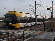
 Light rail train in Minneapolis | ||||||||||||||||||||||||||||||||||||||||||||||||||||||||||||||||||||||||||||||||||||||||||||||||||||||||||||||||||||||||||||||||||||||||||||||||||||||||||||||||||||||||||||||||||||||||||||||||||||||||||||||||||||||||||||||||||||||||||||||||||||||||||||||||||||||||||||||||||||||||||||||||||||||||||||||||||||||||||||||||||||||||||||||||||||||||||||||||||||||||||||||||||||||||||||||||||||||||||||||||||||||||||||||||||||||||||||||||||||||||||
| Overview | ||||||||||||||||||||||||||||||||||||||||||||||||||||||||||||||||||||||||||||||||||||||||||||||||||||||||||||||||||||||||||||||||||||||||||||||||||||||||||||||||||||||||||||||||||||||||||||||||||||||||||||||||||||||||||||||||||||||||||||||||||||||||||||||||||||||||||||||||||||||||||||||||||||||||||||||||||||||||||||||||||||||||||||||||||||||||||||||||||||||||||||||||||||||||||||||||||||||||||||||||||||||||||||||||||||||||||||||||||||||||||
| Status | Operational | |||||||||||||||||||||||||||||||||||||||||||||||||||||||||||||||||||||||||||||||||||||||||||||||||||||||||||||||||||||||||||||||||||||||||||||||||||||||||||||||||||||||||||||||||||||||||||||||||||||||||||||||||||||||||||||||||||||||||||||||||||||||||||||||||||||||||||||||||||||||||||||||||||||||||||||||||||||||||||||||||||||||||||||||||||||||||||||||||||||||||||||||||||||||||||||||||||||||||||||||||||||||||||||||||||||||||||||||||||||||||
| Locale | Minneapolis–St. Paul Metropolitan: Minneapolis, Minnesota Fort Snelling, Minnesota Minneapolis–Saint Paul International Airport Bloomington, Minnesota | |||||||||||||||||||||||||||||||||||||||||||||||||||||||||||||||||||||||||||||||||||||||||||||||||||||||||||||||||||||||||||||||||||||||||||||||||||||||||||||||||||||||||||||||||||||||||||||||||||||||||||||||||||||||||||||||||||||||||||||||||||||||||||||||||||||||||||||||||||||||||||||||||||||||||||||||||||||||||||||||||||||||||||||||||||||||||||||||||||||||||||||||||||||||||||||||||||||||||||||||||||||||||||||||||||||||||||||||||||||||||
| Termini | Mall of America (south) Target Field (north) | |||||||||||||||||||||||||||||||||||||||||||||||||||||||||||||||||||||||||||||||||||||||||||||||||||||||||||||||||||||||||||||||||||||||||||||||||||||||||||||||||||||||||||||||||||||||||||||||||||||||||||||||||||||||||||||||||||||||||||||||||||||||||||||||||||||||||||||||||||||||||||||||||||||||||||||||||||||||||||||||||||||||||||||||||||||||||||||||||||||||||||||||||||||||||||||||||||||||||||||||||||||||||||||||||||||||||||||||||||||||||
| Stations | 19 open, 10 proposed | |||||||||||||||||||||||||||||||||||||||||||||||||||||||||||||||||||||||||||||||||||||||||||||||||||||||||||||||||||||||||||||||||||||||||||||||||||||||||||||||||||||||||||||||||||||||||||||||||||||||||||||||||||||||||||||||||||||||||||||||||||||||||||||||||||||||||||||||||||||||||||||||||||||||||||||||||||||||||||||||||||||||||||||||||||||||||||||||||||||||||||||||||||||||||||||||||||||||||||||||||||||||||||||||||||||||||||||||||||||||||
| Website | Metro Blue Line | |||||||||||||||||||||||||||||||||||||||||||||||||||||||||||||||||||||||||||||||||||||||||||||||||||||||||||||||||||||||||||||||||||||||||||||||||||||||||||||||||||||||||||||||||||||||||||||||||||||||||||||||||||||||||||||||||||||||||||||||||||||||||||||||||||||||||||||||||||||||||||||||||||||||||||||||||||||||||||||||||||||||||||||||||||||||||||||||||||||||||||||||||||||||||||||||||||||||||||||||||||||||||||||||||||||||||||||||||||||||||
| Service | ||||||||||||||||||||||||||||||||||||||||||||||||||||||||||||||||||||||||||||||||||||||||||||||||||||||||||||||||||||||||||||||||||||||||||||||||||||||||||||||||||||||||||||||||||||||||||||||||||||||||||||||||||||||||||||||||||||||||||||||||||||||||||||||||||||||||||||||||||||||||||||||||||||||||||||||||||||||||||||||||||||||||||||||||||||||||||||||||||||||||||||||||||||||||||||||||||||||||||||||||||||||||||||||||||||||||||||||||||||||||||
| Type | Light rail | |||||||||||||||||||||||||||||||||||||||||||||||||||||||||||||||||||||||||||||||||||||||||||||||||||||||||||||||||||||||||||||||||||||||||||||||||||||||||||||||||||||||||||||||||||||||||||||||||||||||||||||||||||||||||||||||||||||||||||||||||||||||||||||||||||||||||||||||||||||||||||||||||||||||||||||||||||||||||||||||||||||||||||||||||||||||||||||||||||||||||||||||||||||||||||||||||||||||||||||||||||||||||||||||||||||||||||||||||||||||||
| System | Metro | |||||||||||||||||||||||||||||||||||||||||||||||||||||||||||||||||||||||||||||||||||||||||||||||||||||||||||||||||||||||||||||||||||||||||||||||||||||||||||||||||||||||||||||||||||||||||||||||||||||||||||||||||||||||||||||||||||||||||||||||||||||||||||||||||||||||||||||||||||||||||||||||||||||||||||||||||||||||||||||||||||||||||||||||||||||||||||||||||||||||||||||||||||||||||||||||||||||||||||||||||||||||||||||||||||||||||||||||||||||||||
| Route number | 901 (whole line, formerly 55) 906 (airport shuttle, formerly 56) | |||||||||||||||||||||||||||||||||||||||||||||||||||||||||||||||||||||||||||||||||||||||||||||||||||||||||||||||||||||||||||||||||||||||||||||||||||||||||||||||||||||||||||||||||||||||||||||||||||||||||||||||||||||||||||||||||||||||||||||||||||||||||||||||||||||||||||||||||||||||||||||||||||||||||||||||||||||||||||||||||||||||||||||||||||||||||||||||||||||||||||||||||||||||||||||||||||||||||||||||||||||||||||||||||||||||||||||||||||||||||
| Operator(s) | Metro Transit | |||||||||||||||||||||||||||||||||||||||||||||||||||||||||||||||||||||||||||||||||||||||||||||||||||||||||||||||||||||||||||||||||||||||||||||||||||||||||||||||||||||||||||||||||||||||||||||||||||||||||||||||||||||||||||||||||||||||||||||||||||||||||||||||||||||||||||||||||||||||||||||||||||||||||||||||||||||||||||||||||||||||||||||||||||||||||||||||||||||||||||||||||||||||||||||||||||||||||||||||||||||||||||||||||||||||||||||||||||||||||
| Daily ridership | 31,471 (avg. weekday, 2015)[1] | |||||||||||||||||||||||||||||||||||||||||||||||||||||||||||||||||||||||||||||||||||||||||||||||||||||||||||||||||||||||||||||||||||||||||||||||||||||||||||||||||||||||||||||||||||||||||||||||||||||||||||||||||||||||||||||||||||||||||||||||||||||||||||||||||||||||||||||||||||||||||||||||||||||||||||||||||||||||||||||||||||||||||||||||||||||||||||||||||||||||||||||||||||||||||||||||||||||||||||||||||||||||||||||||||||||||||||||||||||||||||
| History | ||||||||||||||||||||||||||||||||||||||||||||||||||||||||||||||||||||||||||||||||||||||||||||||||||||||||||||||||||||||||||||||||||||||||||||||||||||||||||||||||||||||||||||||||||||||||||||||||||||||||||||||||||||||||||||||||||||||||||||||||||||||||||||||||||||||||||||||||||||||||||||||||||||||||||||||||||||||||||||||||||||||||||||||||||||||||||||||||||||||||||||||||||||||||||||||||||||||||||||||||||||||||||||||||||||||||||||||||||||||||||
| Opened | June 26, 2004 | |||||||||||||||||||||||||||||||||||||||||||||||||||||||||||||||||||||||||||||||||||||||||||||||||||||||||||||||||||||||||||||||||||||||||||||||||||||||||||||||||||||||||||||||||||||||||||||||||||||||||||||||||||||||||||||||||||||||||||||||||||||||||||||||||||||||||||||||||||||||||||||||||||||||||||||||||||||||||||||||||||||||||||||||||||||||||||||||||||||||||||||||||||||||||||||||||||||||||||||||||||||||||||||||||||||||||||||||||||||||||
| Technical | ||||||||||||||||||||||||||||||||||||||||||||||||||||||||||||||||||||||||||||||||||||||||||||||||||||||||||||||||||||||||||||||||||||||||||||||||||||||||||||||||||||||||||||||||||||||||||||||||||||||||||||||||||||||||||||||||||||||||||||||||||||||||||||||||||||||||||||||||||||||||||||||||||||||||||||||||||||||||||||||||||||||||||||||||||||||||||||||||||||||||||||||||||||||||||||||||||||||||||||||||||||||||||||||||||||||||||||||||||||||||||
| Line length | 12 mi (19.3 km)[2] | |||||||||||||||||||||||||||||||||||||||||||||||||||||||||||||||||||||||||||||||||||||||||||||||||||||||||||||||||||||||||||||||||||||||||||||||||||||||||||||||||||||||||||||||||||||||||||||||||||||||||||||||||||||||||||||||||||||||||||||||||||||||||||||||||||||||||||||||||||||||||||||||||||||||||||||||||||||||||||||||||||||||||||||||||||||||||||||||||||||||||||||||||||||||||||||||||||||||||||||||||||||||||||||||||||||||||||||||||||||||||
| Number of tracks | 2 | |||||||||||||||||||||||||||||||||||||||||||||||||||||||||||||||||||||||||||||||||||||||||||||||||||||||||||||||||||||||||||||||||||||||||||||||||||||||||||||||||||||||||||||||||||||||||||||||||||||||||||||||||||||||||||||||||||||||||||||||||||||||||||||||||||||||||||||||||||||||||||||||||||||||||||||||||||||||||||||||||||||||||||||||||||||||||||||||||||||||||||||||||||||||||||||||||||||||||||||||||||||||||||||||||||||||||||||||||||||||||
| Character | Primarily At grade, in mostly separated right of way, but with some street running, one underground section, including one underground station. | |||||||||||||||||||||||||||||||||||||||||||||||||||||||||||||||||||||||||||||||||||||||||||||||||||||||||||||||||||||||||||||||||||||||||||||||||||||||||||||||||||||||||||||||||||||||||||||||||||||||||||||||||||||||||||||||||||||||||||||||||||||||||||||||||||||||||||||||||||||||||||||||||||||||||||||||||||||||||||||||||||||||||||||||||||||||||||||||||||||||||||||||||||||||||||||||||||||||||||||||||||||||||||||||||||||||||||||||||||||||||
| Track gauge | 4 ft 8+1⁄2 in (1,435 mm) standard gauge | |||||||||||||||||||||||||||||||||||||||||||||||||||||||||||||||||||||||||||||||||||||||||||||||||||||||||||||||||||||||||||||||||||||||||||||||||||||||||||||||||||||||||||||||||||||||||||||||||||||||||||||||||||||||||||||||||||||||||||||||||||||||||||||||||||||||||||||||||||||||||||||||||||||||||||||||||||||||||||||||||||||||||||||||||||||||||||||||||||||||||||||||||||||||||||||||||||||||||||||||||||||||||||||||||||||||||||||||||||||||||
| Minimum radius | 82 feet (25 m) | |||||||||||||||||||||||||||||||||||||||||||||||||||||||||||||||||||||||||||||||||||||||||||||||||||||||||||||||||||||||||||||||||||||||||||||||||||||||||||||||||||||||||||||||||||||||||||||||||||||||||||||||||||||||||||||||||||||||||||||||||||||||||||||||||||||||||||||||||||||||||||||||||||||||||||||||||||||||||||||||||||||||||||||||||||||||||||||||||||||||||||||||||||||||||||||||||||||||||||||||||||||||||||||||||||||||||||||||||||||||||
| Electrification | Overhead lines, 750 V DC | |||||||||||||||||||||||||||||||||||||||||||||||||||||||||||||||||||||||||||||||||||||||||||||||||||||||||||||||||||||||||||||||||||||||||||||||||||||||||||||||||||||||||||||||||||||||||||||||||||||||||||||||||||||||||||||||||||||||||||||||||||||||||||||||||||||||||||||||||||||||||||||||||||||||||||||||||||||||||||||||||||||||||||||||||||||||||||||||||||||||||||||||||||||||||||||||||||||||||||||||||||||||||||||||||||||||||||||||||||||||||
| Operating speed | 55 mph (89 km/h) max 18 mph (29 km/h) average | |||||||||||||||||||||||||||||||||||||||||||||||||||||||||||||||||||||||||||||||||||||||||||||||||||||||||||||||||||||||||||||||||||||||||||||||||||||||||||||||||||||||||||||||||||||||||||||||||||||||||||||||||||||||||||||||||||||||||||||||||||||||||||||||||||||||||||||||||||||||||||||||||||||||||||||||||||||||||||||||||||||||||||||||||||||||||||||||||||||||||||||||||||||||||||||||||||||||||||||||||||||||||||||||||||||||||||||||||||||||||
| ||||||||||||||||||||||||||||||||||||||||||||||||||||||||||||||||||||||||||||||||||||||||||||||||||||||||||||||||||||||||||||||||||||||||||||||||||||||||||||||||||||||||||||||||||||||||||||||||||||||||||||||||||||||||||||||||||||||||||||||||||||||||||||||||||||||||||||||||||||||||||||||||||||||||||||||||||||||||||||||||||||||||||||||||||||||||||||||||||||||||||||||||||||||||||||||||||||||||||||||||||||||||||||||||||||||||||||||||||||||||||
The Metro Blue Line (formerly called the 55 - Hiawatha Line)[3] is a 12-mile (19.3 km)[2] light rail line in Hennepin County, Minnesota that extends from downtown Minneapolis to the southern suburb of Bloomington. The line was originally named after Hiawatha Avenue which runs parallel to a good portion of the line. Major locations on the line include the Mall of America, Minneapolis–St. Paul International Airport and Target Field in downtown Minneapolis.
The Blue Line is operated by Metro Transit, which is also the primary operator of buses in the Twin Cities. The line accounts for about 13% of Metro Transit's total ridership. Less than two years after opening, the line had already exceeded its 2020 weekday ridership goal of 24,800.[4] The line carried 10.6 million riders in 2015.[1]
Blue Line stations serving the Lindbergh and Humphrey terminals of MSP Airport operate 24 hours a day, 7 days a week. The remainder of the Blue Line operates from 3:29 a.m. to 1:54 a.m. Monday through Thursday, and 24 hours a day from 3:29 a.m. on Friday morning to 1:54 a.m. on Sunday morning.[5][6]
History[]
This section needs additional citations for verification. (February 2018) |

Background[]
The Minneapolis–St. Paul area once had an extensive network of streetcars (operated for many years by Twin City Rapid Transit, a precursor of Metro Transit), but the tracks were removed and services were eliminated in the 1950s.
Over the years since the last trolley ran in 1954, many people have pushed for the reintroduction of rail transport in the Twin Cities. Proposals for a modern streetcar or light rail along the Hiawatha Avenue corridor appeared in the pages of the Star Tribune as early as 1974.[7] The primary reason is that traffic congestion has grown considerably since the streetcar system ceased operation: a 2003 report by the Texas Transportation Institute indicated that the area was the 17th most congested area in the country, with the second fastest congestion growth.
Rail projects struggled to gain political support until the 1990s, when several factors combined to make the idea more palatable. Governor Jesse Ventura and Minnesota Transportation Commissioner Elwyn Tinklenberg heavily promoted the idea of rail transport, and significant amounts of money became available from the federal government. Previous governors had advocated light rail, but had not been able to get legislation passed. Governor Tim Pawlenty had campaigned on a promise to fight the expansion of light rail, but altered his opinions after taking office. He also initially opposed the Northstar Line commuter rail project, which is a rail corridor north of Minneapolis, but changed his mind about that project in January 2004 when a scaled-back version was shown to have good potential.[8]
Project development[]
For many,[who?] the Hiawatha Avenue corridor was not the top choice for a new project. Popular other options included connecting Minneapolis with the western suburbs, though probably the most-desired option has been the Central Corridor connecting the Twin Cities themselves (Minneapolis and St. Paul) with a route down the middle of Interstate 94 or University Avenue. However, much of the land had already been acquired by the state in the 1960s to build a sunken radial expressway into downtown that was never built. In addition to the available land, the desire to connect to the airport and at least reach the vicinity of the Mall of America proved to be the bigger draw for decision-makers.[9]
The idea of running a rail line down Hiawatha Avenue had already been around for at least a decade by the time the decision was made to go forward. In 1985, the Minnesota Department of Transportation (Mn/DOT) had produced an Environmental Impact Statement that concluded that light rail was the best alternative for the corridor.[10] In 1996, the document was examined again as Mn/DOT looked at the possibility of adding bus rapid transit along the road, but money for light rail became available soon after, leading to the current layout.
Construction and opening[]
The line's cost totaled $715.3 million, with $334.3 million coming from the federal government.[11] This is considerably higher than initial budgets predicted—the figure was about $400 million in 1997. Opponents to the rail line state that it went far over-budget, but supporters of the line state that extensions of the route and other alterations, plus the impact of inflation, are the real reasons for the increased cost. Initial designs cut out the last stop in downtown, and the southern end of the line did not quite connect to the Mall of America. The Warehouse District stop was added early but another cost increase came from approximately $40 million to enhance the line (while construction was in progress) to bring the line directly into the Mall of America's transit hub. It was completed later than what was initially hoped for (a lot of literature points to 2003 as the opening year), but the mall connection was a significant contribution to the extra time requirements. These extensions are also why the line was initially reported to be 11.6 miles (18.7 km) long, but ended up being 12 miles (19 km) in length. The Target Field extension in 2009 added a few more tenths to the length. Groundbreaking for the line took place on January 17, 2001.
In March 2004, the labor union representing Metro Transit bus workers went on strike. This delayed the opening of the line from the anticipated start date of April 3, although there was some indication that the opening would have been delayed anyway. Apparently, some of the delay had to do with slow delivery of trainsets from Bombardier. Certain aspects of the design had been tried before, but the cars were the first to combine the factors of conforming to American standards (as opposed to European), having low floors and being built at the company's Mexico plant. Some problems also cropped up during testing of the vehicles, but Bombardier said that the issues were not out of the ordinary.
When the buses began rolling again on April 19, the line's opening was rolled back to June 26. Testing of the track and vehicles continued during the bus strike, as much of the work was performed by Bombardier employees rather than Metro Transit workers. Train operators who had already gone through the training process were given refresher courses when the strike ended. Regular service began on the first phase of the line on June 26, 2004, with the second phase opening later that year on December 4. Each opening was accompanied with two days of free rides on the train and area buses. The line was tested for months before opening, with regular service simulated for about a month before each phase went online. The Hiawatha Line opened exactly 50 years and one week after the last regular-service streetcars ran in the city.
Light rail staff, security, and volunteers produced a largely hitch-free opening day for the new rail system on June 26, 2004.[12] Officials estimated 30,000 people boarded the electric-powered trains during the transit system's first day of service. Train rides were free. Each station featured live entertainment and food as a diversion for the long waits to board the trains. Predicted daily ridership was 19,300 for 2005 and 24,600 for 2020.
Developments post-opening[]

Busways are still being examined for many future projects and it appears likely that at least one will be built. Construction of the area's second light rail line, the Green Line connecting downtown Minneapolis and St. Paul began in late 2010 and opened on June 14, 2014. On April 26, 2011, the U.S. government announced $478 million in funding for its construction.[13]
During Super Bowl LII on February 4, 2018, hosted at U.S. Bank Stadium, the Blue Line was restricted to ticketholders and ran with non-stop service between a security checkpoint at the Mall of America and the stadium station. Service at other stations was replaced with free shuttle buses.[14][15]
In July 2011, the Metropolitan Council officially approved renaming the Hiawatha Line as the Blue Line. This is part of a broader color scheme for identifying Twin Cities transit lines, including the Green Line light rail to St. Paul, the proposed Orange Line bus rapid transit along I-35W, and the operational Red Line bus rapid transit service along Cedar Avenue.[16] The name officially changed on Friday, May 17, 2013.[17]
Proposed extension[]
An extension of the line to Brooklyn Park is planned. On August 3, 2020, after years of disagreements with The Burlington Northern Santa Fe (BNSF) Railway Company regarding use of BNSF's right-of-way, Metropolitan Council announced they would begin to "explore opportunities to advance this critical project without using BNSF Railway right of way."[18]
On March 11, 2021, the Metropolitan Council and Hennepin County released revised potential route options for the proposed Blue Line Extension. The proposed new routes retain the northern part of the original alignment, but offer different routes through north Minneapolis, and (unlike the original plan) bypass the suburb of Golden Valley.[19]
Route[]
The Blue Line runs from downtown Minneapolis to the Mall of America for a length of 12 mi (19.3 km).[2] The southern terminus at the Mall of America station and transit center is located beneath the east parking ramp of the mall and has direct access to the mall.[20] The station offers connections to the Red Line and other local bus routes including those operated by Minnesota Valley Transit Authority. From the Mall of America trains travel east towards the 28th Avenue station park-and-ride ramp. The route travels through Bloomington's South Loop District before reaching the Terminal 2–Humphrey station of the MSP Airport across from Fort Snelling National Cemetery. To cross the MSP Airport the line then enters a pair of 7,300 feet (2,200 m) tunnels that required a tunnel boring machine and cost $110 million to construct. While traveling through the tunnels, trains stop at the 65 feet (20 m) underground Terminal 1–Lindbergh station.[21][22] Once emerging from the tunnel, the line serves two park-and-ride lots at Fort Snelling station. From Fort Snelling station, the line travels on the surface in separated right of way parallel to Minnesota State Highway 55 while stopping at stations near the VA Medical center, Minnehaha Park, and other locations in south Minneapolis. Trains travel on bridges over traffic at busy intersections near Lake Street and Franklin Ave with overhead stations located at each crossing.
After crossing to the other side of Highway 55, the line runs on the former Chicago, Milwaukee, St. Paul & Pacific Short Line roadbed which brought Hiawatha passenger trains to the downtown depot. After crossing I-35W on a dedicated bridge, the train begins to share tracks with the Green Line and enters downtown by traveling around U.S. Bank Stadium. The U.S. Bank Stadium station is surrounded by a pedestrian plaza that is used for loading riders onto trains after events at US Bank Stadium.[23] While passing the Downtown East Commons, the route travels through downtown on surface streets. The line shares the road with one lane of automobile traffic through downtown with the exception of the block along Government Plaza station where the street is closed and a pedestrian plaza connecting the Minneapolis City Hall and the Hennepin County Government Center.[24] With a stop at Nicollet Mall the line offers connections to an important transit and pedestrian corridor. The train terminates at Target Field station which offers connections to the Northstar Commuter Rail.

Stations[]

Each of the 19 stations along the route is designed in a unique architectural style reflective of the station's surrounding community. This is not an entirely new idea for the region, as many of the higher-traffic bus stops around the city have distinctive designs. Due to the unique makeup of Minneapolis' population, ticket-dispensing machines present instructions in four languages: English, Spanish, Somali and Hmong. Travel time is roughly two to three minutes between most stations.
The airport used to operate a bus shuttle between the two terminals, but the light-rail line has replaced that service. No fare is required to ride between the two airport stations and trains run between these 2 stations 24 hours a day, 7 days a week.[25] Only seven of the original 17 stations was built to accommodate three car trains, but due to the need to increase the line's capacity, the remaining stations were retrofitted or extended to accommodate three-car trains in 2009. The extensions were paid for primarily with federal money but the Metropolitan Council, Hennepin County, and city of Bloomington also contributed some funds.[26]
Station additions[]
The Blue Line was extended several blocks northwest from the Warehouse District/Hennepin Avenue station to the Target Field Station in 2009. The station was paid for by the Minnesota Twins as part of the construction and opening of Target Field.[27] The two-level station has light rail platforms on the upper level for use by Blue Line and Green Line light rail trains, and platforms next to the BNSF mainline tracks passing beneath the station to serve the Northstar Line commuter rail. The under construction Green Line extension, also known as the Southwest Corridor, will connect directly to the end of the Blue Line to share service with the station.[28]
Largely federal money but also with some local contributions was secured for construction of the new American Boulevard Station in Bloomington between the Humphrey Terminal Station and Bloomington Central Station. This station was included in the line's original plans, but was postponed due to cost overruns. Because much of the necessary underground infrastructure for the station was installed when the line was constructed, the station was built with minimal service interruptions.[26][29]
Service[]
Passengers who ride the rail system are charged the same fare as they would pay for the local Metro Transit bus system, and they are able to use their bus transfer cards to switch between the two different modes of transportation without making another payment. A new payment system using smart cards (locally known as Go-To Cards) was initially expected to be introduced along with the rail line in June 2004, but software bugs delayed introduction. By September 2006, the bugs were worked out and the Go-To Cards became operational.
In basic service trains operate every 10 to 15 minutes and operate less frequently in the early morning and late-night. Additional trains operate on Friday and Saturday nights.[30] The line shuts down for about two hours each night, except for a shuttle service between the two terminals at the MSP airport and for the northbound trips between Cedar-Riverside and Target Field Station which run 24 hours a day. Vehicles have a capacity of 66 seated passengers and 120 standing. Currently two or three vehicles are run together to increase capacity.
Ridership[]
The line accounts for about 13% of Metro Transit's total ridership. Less than two years after opening, the line had already exceeded its 2020 weekday ridership goal of 24,800.[31] The line carried 10.6 million riders in 2015.[1] In 2018 weekday ridership on the Blue Line was 32,921.[32] Rideship for both the Green and Blue Lines combined was down 59% in 2020 due to the effects of the COVID-19 pandemic.[33]
Fares[]
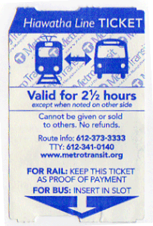
The Blue Line uses a proof-of-payment system, requiring riders to carry tickets at all times. Fares are purchased before boarding, either at ticket machines located in the stations or by scanning a Go-To card at dedicated pedestals. Tickets are valid for 2 1/2 hours after purchase, with transfers available to other Metro lines as well as any Metro Transit bus routes. Fares can range from 50¢ within the two Downtown Zones of Minneapolis and St. Paul to $2.50 for adults in rush hours.[34]
Rolling stock[]
Currently[when?] the Blue Line uses 27 Bombardier Flexity Swift light rail vehicles (LRVs) manufactured by and 12 Siemens S70 LRVs. The system is designed to output 750 volts of direct current. Trains can reach speeds of 55 miles per hour (88.5 km/h), but the “general service speed” is about 40 mph (64.4 km/h) or slower (especially in the congested downtown region). They are of a 70% low-floor design, meaning that 70 percent of the floor inside is within about 14 inches (356 mm) of the ground. This is the same height as the rail platforms, allowing stepless access for passengers dependent on wheelchairs or other mobility aids. The feature also makes it easier for passengers with bicycles or strollers to board the train. Each vehicle weighs about 107,000 pounds (48,534 kg) when empty. Minneapolis is the first and only city to use this LRV model in the United States.[35]
Vehicles have a color scheme that is primarily a combination of blue, yellow and white. Yellow was the color used on the previous streetcar system in the area. Each vehicle has an A, B and C section: The A and B sections are the large portions on each end, while the C section is a small portion that connects the two other pieces and has the vehicle's middle truck or bogie. Electricity is collected by a pantograph mounted on the B section. The first "Type I" LRV was delivered on March 19, 2003. 14 of 15 delivered vehicles were operational for the opening weekend. The initial order was eventually bumped up to a full 24 vehicles, which were operational by early 2005. Three additional vehicles were ordered in the winter of 2006/2007, using leftover funds from the construction budget for one vehicle and Hennepin County funds for the other two.
The noses of these vehicles are built to a different design than is standard for the Flexity Swift, containing a small scoop-shaped area. This assists in the removal of snow, but the anticipated snow-management method is merely to run trains on a frequent basis rather than actually using snow removal equipment (this was what the earlier streetcar system usually did to keep lines clear, though they also often featured small scrapers in front of the lead wheels).
Each vehicle has a number of cameras on board, pointing both inward and outward, to monitor passenger activity and other areas of interest for security and safety. Train stations also have cameras. Video feeds and the position of each vehicle on the line are monitored in a control room at the system's maintenance facility, located between Cedar-Riverside and Franklin Avenue stations.
According to Metropolitan Council meeting notes dated July 30, 2010 for the August 9 Transportation Committee meeting, Siemens Industry Incorporated agreed to build the Light Rail Vehicles for the three-car train expansion project in a joint procurement with the Green Line's initial LRV procurement, at a per-LRV cost of $3,297,714 and a total contract value of $153,211,516.[36] According to Mark Fuhrmann's presentation at the July 26, 2010 Transportation Committee meeting, these "Type II" LRVs are mechanically, but not electronically, compatible with the current fleet of 27 "type I" vehicles, so while the two generations are able to run at the same time and either type would be able to push a malfunctioning unit of the other type, multiple-unit trains can only be assembled of one type.[37] The Metro Blue Line uses 12 "Type II" S70 LRVs.
Safety[]

With an expansion of the light rail system happening with the opening of the Green Line in 2014, Metro Transit rolled out a new rail safety campaign, with representatives of Metro Transit customers visiting schools and organizations situated near the Blue Line to discuss rail safety.[38] The campaign won a visual design award from the Minnesota Association of Government Communicators.[39] By January 2015, there had been 11 deaths from accidents on the line, eight of them pedestrians.[40][41] After two more people were killed in separate incidents on the Blue Line, one a bicyclist and one a man in a wheelchair, signs saying "See Tracks? Think Train" were added at locations of recent deaths along the Blue Line and Green Line.[42][43] As of September 2019, 15 people have died in crashes with Blue Line trains.[44]
Additionally, there has been concern over violent assaults, robberies, and disorderly conduct that occurs on the station platforms while people wait for the trains. There was a murder by stabbing at the Lake Street/Midtown station in December 2014.[45] Aggravated assaults, which involve the use of a weapon to cause serious injury, continued to increase through 2019 including another murder by stabbing at the Lake Street/Midtown station in October 2017.[46] Increased police officer hours, including the use of plainclothes police officers, were added to address safety concerns in 2019. Other efforts included allowing riders to text a number to communicate with police and teams dedicated to helping homeless riders were added in the same year.[47] In January 2020, the Met Council approved $1.3 million in spending to install new 360-degree 4K resolution cameras on all Metro Transit light rail cars by the end of 2020.[48] Another stabbing that resulted in death occurred on a train in Bloomington in January 2020, but no charges were filed due to claims of self-defense.[49]
See also[]
References[]
- ^ a b c "Metro Transit ridership tops 85.8 million in 2015" (Press release). Metro Transit. January 22, 2016. Retrieved August 3, 2016.
- ^ a b c "Metro Blue Line - Facts About Trains and Construction". Metro Transit. 2013. Archived from the original on 2014-02-14. Retrieved 2014-06-15.
- ^ "These routes will change May 18". Metro Transit. Retrieved 2013-05-03.
- ^ "Minneapolis: More spectacular ridership gains for Hiawatha light rail transit". Light Rail Now. August 2008. Retrieved December 17, 2009.
- ^ "Metro Transit - Online Schedules - METRO Green Line". www.metrotransit.org.
- ^ "Metro Transit - Online Schedules - METRO Blue Line". www.metrotransit.org.
- ^ Mike, Anderson (June 18, 1974). "Streetcars Proposed to Ease Transit Woe". Star Tribune.
- ^ Laura McCallum (August 3, 2004). "Pawlenty finds money to jumpstart North Star rail line". Minnesota Public Radio.
- ^ Newberg, Sam (May 2004). "Light Rail Comes to Minnesota" (PDF). community-wealth.org. American Planning Association. Archived from the original (PDF) on 11 October 2011. Retrieved 3 December 2013.
- ^ Collopy, Trisha (Summer 2004). "The Right Track". Inventing Tomorrow (University of Minnesota). Archived from the original on July 20, 2011. Retrieved December 17, 2009.
- ^ "Facts About Trains and Construction". Metro Transit. Archived from the original on April 26, 2010. Retrieved December 29, 2012.
- ^ "Down the Line; Light Rail's First Day." Star Tribune; June 27, 2004
- ^ Van Denburg, Hart (April 2011). "Feds signing over $478 million in Central Corridor funding today". City Pages. Archived from the original on May 18, 2011. Retrieved April 26, 2011.
- ^ Harlow, Tim (January 12, 2018). "A month of Super Bowl disruptions ahead for Metro Transit riders". Star-Tribune. Retrieved February 10, 2018.
- ^ Harlow, Tim (February 4, 2018). "Mixed reviews for Super Bowl Sunday transit service". Star-Tribune. Retrieved February 10, 2018.
- ^ "Met Council approves line color names for region's developing transitway system". Metropolitan Council. July 2011. Archived from the original on August 7, 2011. Retrieved August 31, 2011.
- ^ "Hiawatha light-rail name to be phased out for Blue Line". StarTribune. May 17, 2013. Retrieved May 23, 2013.
- ^ "Project partners announce new direction for METRO Blue Line Extension". 3 August 2020. Retrieved 3 August 2020.
- ^ "Reboot of Bottineau Blue Line LRT would better serve north Minneapolis". 12 March 2020. Retrieved 12 March 2020.
- ^ Moore, Janet (19 February 2020). "New $25 million Mall of America transit station set to welcome visitors 'in style'". Star Tribune. Star Tribune. Retrieved 27 February 2020.
- ^ Wascoe Jr., Dan (October 8, 2001). "Looking for light at the end of the tunnel". Star Tribune.
- ^ Wascoe Jr., Dan (August 30, 2002). "A boring project that's anything but". Star Tribune.
- ^ Harlow, Tim (August 27, 2016). "Metro Transit's Rail Control Center leans in to stadium learning curve". Star Tribune. Retrieved 4 June 2021.
- ^ "On Monday, chunk of 5th St. will be closed permanently". Star Tribune. March 2, 2002.
- ^ "Metro Blue Line schedule". Metro. Retrieved August 3, 2016.
- ^ a b Duch, Kevinschere (August 26, 2009). "Light-rail upgrades running on time". Star Tribune. Retrieved 5 June 2021.
- ^ Duchschere, Kevin (October 28, 2009). "Sprucing up 'round the park". Star Tribune. Retrieved 5 June 2021.
- ^ "Minneapolis Detail Map". Hennepin County (Southwest Corridor). Archived from the original on 2008-10-08. Retrieved 2009-02-04.
- ^ "Two New Stations in the Works for Hiawatha Line in Minneapolis". Mass Transit Magazine. Retrieved 2009-02-04.[permanent dead link]
- ^ "Metro Blue Line - Mpls - Airport - MOA". Metro Transit. Retrieved July 7, 2016.
- ^ "Minneapolis: More spectacular ridership gains for Hiawatha light rail transit". Light Rail Now. August 2008. Retrieved December 17, 2009.
- ^ Kerr, Drew (February 11, 2019). "Light rail, Bus Rapid Transit lines set annual ridership records". Retrieved 3 June 2021.
- ^ Moore, Janet (February 23, 2021). "Met Council: Ridership on Metro Transit plunged in 2020, owing to pandemic". Star Tribune. Retrieved 3 June 2021.
- ^ "Fares". Metro Transit. Retrieved 3 June 2021.
- ^ "Bombardier FLEXITY Swift – Minneapolis/St. Paul, USA". Bombardier. Retrieved 2007-01-31.
- ^ "Transportation Committee Business Item 2010-275" (PDF). Metropolitan Council. 2010-07-30. Retrieved 2010-08-06.
- ^ "Transportation Committee Meeting July 26, 2010". Metropolitan Council. 2010-07-26. Retrieved 2010-08-06.
- ^ Harlow, Tim (2013-09-13). "The Drive: Prohibited turns bring light-rail mishaps". The Star Tribune.
- ^ Minnesota Association of Government Communicators (2013-05-20). "2013 Award Winners" (PDF). Northern Lights Awards. Archived from the original (PDF) on 2013-09-30.
- ^ Nelson, Tim (13 January 2014). "Minneapolis light rail train hits, kills pedestrian". Minnesota Public Radio. Retrieved 13 January 2014.
- ^ McKinney, Matt. "Woman struck and killed by Blue Line light-rail train in south Minneapolis". StarTribune. Retrieved 2014-06-20.
- ^ Harlow, Tim. "Man hit by light-rail train is ID'd; witness says wheelchair had wheel in air". StarTribune. Retrieved 2016-01-22.
- ^ Harlow, Tim. "Rail safety signs pop up near three pedestrian deaths". StarTribune. Retrieved 2016-01-22.
- ^ Harlow, Tim (September 6, 2019). "Bicyclist killed in Minneapolis crash with light-rail train was Richfield man". Star Tribune. Retrieved 5 June 2021.
- ^ Collins, Liz. "Rail safety signs pop up near three pedestrian deaths". WCCO. Retrieved 2016-01-22.
- ^ Lyden, Tom (2019-10-31). "Danger on the line: Assaults up at light rail stations". FOX 9. Retrieved 2020-01-23.
- ^ Callaghan, Peter (February 13, 2020). "Met Council chief vows to improve safety on Twin Cities buses, light rail". MinnPost. Retrieved 3 June 2021.
- ^ "Metro Transit Considers Adding New Cameras To Light Rail". 2020-01-22. Retrieved 2020-01-23.
- ^ "No charges filed in fatal stabbing on Blue Line train". St. Paul Pioneer Press. Associated Press. 2020-01-24. Retrieved 6 June 2021.
External links[]
Route map:

| ( • help)
|
| Wikimedia Commons has media related to METRO Blue Line. |
- Light rail in Minnesota
- Minneapolis–Saint Paul
- Transportation in Minneapolis
- Railway lines opened in 2004
- Airport rail links in the United States
- Transportation in Hennepin County, Minnesota
- 750 V DC railway electrification
- Metro Transit (Minnesota)