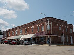
Lost Nation, Iowa
Lost Nation, Iowa | |
|---|---|
 | |
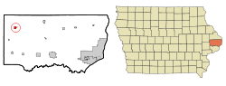 Location of Lost Nation, Iowa | |
| Coordinates: 41°57′51″N 90°49′3″W / 41.96417°N 90.81750°WCoordinates: 41°57′51″N 90°49′3″W / 41.96417°N 90.81750°W | |
| Country | |
| State | |
| County | Clinton |
| Incorporated | July 9, 1903 [1] |
| Area | |
| • Total | 0.64 sq mi (1.65 km2) |
| • Land | 0.64 sq mi (1.65 km2) |
| • Water | 0.00 sq mi (0.00 km2) |
| Elevation | 755 ft (230 m) |
| Population | |
| • Total | 434 |
| • Density | 681.2/sq mi (263.03/km2) |
| Time zone | UTC-6 (Central (CST)) |
| • Summer (DST) | UTC-5 (CDT) |
| ZIP code | 52254 |
| Area code(s) | 563 |
| FIPS code | 19-46605 |
| GNIS feature ID | 0458634 |
| Website | lostnationiowa |

Lost Nation is a city in Clinton County, Iowa, United States. The population was 434 at the time of the 2020 census.[3]
History[]
Lost Nation was platted in 1872 and became an incorporated community in July 1903. [4] A train station was established along the Sabula, Ackley and Dakota railroad in 1871. In 1911, the town was one of the few small towns in the eastern part of the state to be powered by electricity.[5]
Geography[]
According to the United States Census Bureau, the city has a total area of 0.64 square miles (1.66 km2), all land.[6]
Demographics[]
| Year | Pop. | ±% |
|---|---|---|
| 1910 | 523 | — |
| 1920 | 537 | +2.7% |
| 1930 | 493 | −8.2% |
| 1940 | 493 | +0.0% |
| 1950 | 557 | +13.0% |
| 1960 | 567 | +1.8% |
| 1970 | 547 | −3.5% |
| 1980 | 524 | −4.2% |
| 1990 | 467 | −10.9% |
| 2000 | 497 | +6.4% |
| 2010 | 446 | −10.3% |
| 2020 | 434 | −2.7% |
| Source:"U.S. Census website". United States Census Bureau. Retrieved 2020-03-29. and Iowa Data Center Source: | ||

2010 census[]
As of the census[8] of 2010, there were 446 people, 201 households, and 120 families living in the city. The population density was 696.9 inhabitants per square mile (269.1/km2). There were 221 housing units at an average density of 345.3 per square mile (133.3/km2). The racial makeup of the city was 99.1% White and 0.9% African American. Hispanic or Latino of any race were 1.3% of the population.
There were 201 households, of which 25.9% had children under the age of 18 living with them, 45.3% were married couples living together, 8.5% had a female householder with no husband present, 6.0% had a male householder with no wife present, and 40.3% were non-families. 36.8% of all households were made up of individuals, and 18.9% had someone living alone who was 65 years of age or older. The average household size was 2.22 and the average family size was 2.85.
The median age in the city was 44.2 years. 23.3% of residents were under the age of 18; 5.9% were between the ages of 18 and 24; 21.8% were from 25 to 44; 29.3% were from 45 to 64; and 19.7% were 65 years of age or older. The gender makeup of the city was 47.8% male and 52.2% female.
2000 census[]
As of the census[9] of 2000, there were 497 people, 210 households, and 136 families living in the city. The population density was 773.7 people per square mile (299.8/km2). There were 225 housing units at an average density of 350.3 per square mile (135.7/km2). The racial makeup of the city was 98.99% White, 0.20% Asian, and 0.80% from two or more races. Hispanic or Latino of any race were 0.80% of the population.
There were 210 households, out of which 30.0% had children under the age of 18 living with them, 52.4% were married couples living together, 7.6% had a female householder with no husband present, and 34.8% were non-families. 30.5% of all households were made up of individuals, and 21.0% had someone living alone who was 65 years of age or older. The average household size was 2.37 and the average family size was 2.88.
In the city, the population was spread out, with 26.2% under the age of 18, 8.9% from 18 to 24, 22.1% from 25 to 44, 21.5% from 45 to 64, and 21.3% who were 65 years of age or older. The median age was 39 years. For every 100 females, there were 84.8 males. For every 100 females age 18 and over, there were 83.5 males.

The median income for a household in the city was $31,354, and the median income for a family was $34,792. Males had a median income of $27,708 versus $20,714 for females. The per capita income for the city was $13,933. About 15.4% of families and 15.3% of the population were below the poverty line, including 17.2% of those under age 18 and 14.6% of those age 65 or over.
Arts and culture[]
Annual events[]
Rustic Days[]
The annual Rustic Days in Lost Nation take place during the third weekend of July. Rustic Days include a Rustic Run, a parade, and a street dance. Irma Neiber is the treasurer.
Education[]
It is within the Midland Community School District.[10] The Lost Nation school district merged into the Midland district on July 1, 1993.[11]
Notable people[]

- Jim McAndrew (1944– ) Major League Baseball pitcher and World Series Champion for the New York Mets[12]
- Ken Ploen (1935- ) Canadian Football League hall of fame quarterback for the Winnipeg Blue Bombers
- Joe Seng (1946-2016), Iowa state legislator
- George Stone (1876–1945) Major League Baseball left fielder and AL batting champion[13]
See also[]
- Sharon Methodist Episcopal Church, also known as Smithtown Church, is located north of town and is listed on the National Register of Historic Places.
References[]
- ^ "Lost Nation, Iowa". City-Data. Retrieved January 23, 2011.
- ^ "2019 U.S. Gazetteer Files". United States Census Bureau. Retrieved July 17, 2020.
- ^ a b c "2020 Census State Redistricting Data". census.gov. United states Census Bureau. Retrieved 12 August 2021.
- ^ Wolfe, Patrick B. (1911). Wolfe's History of Clinton County, Iowa, Volume 1. B. F. Bowen. pp. 275.
- ^ Wolfe, Patrick B. (1911). Wolfe's History of Clinton County, Iowa, Volume 1. B. F. Bowen. pp. 292.
- ^ "US Gazetteer files 2010". United States Census Bureau. Archived from the original on 2012-07-02. Retrieved 2012-05-11.
- ^ "Census of Population and Housing". Census.gov. Retrieved June 4, 2015.
- ^ "U.S. Census website". United States Census Bureau. Retrieved 2012-05-11.
- ^ "U.S. Census website". United States Census Bureau. Retrieved 2008-01-31.
- ^ "Midland" (PDF). Iowa Department of Education. Retrieved 2020-03-26.
- ^ "REORGANIZATION & DISSOLUTION ACTIONS SINCE 1965-66" (PDF). Iowa Department of Education. Archived from the original (PDF) on 2019-02-09. Retrieved 2020-03-22.
- ^ "Jim McAndrew". BASEBALL-Reference. Retrieved January 23, 2011.
- ^ "George Stone". BASEBALL-Reference. Retrieved January 23, 2011.
External links[]
| Wikimedia Commons has media related to Lost Nation, Iowa. |
- Official City Website
- Chamber of Commerce
- A documentary film title inspired by the city "Lost Nation: The Ioway"
- City-Data Comprehensive Statistical Data and more about Lost Nation
Municipalities and communities of Clinton County, Iowa, United States | ||
|---|---|---|
| Cities | ||
| Townships | ||
| CDP | ||
| Other communities | ||
| Footnotes | ‡This populated place also has portions in an adjacent county or counties | |
| ||
- Cities in Iowa
- Cities in Clinton County, Iowa
- 1872 establishments in Iowa
- Populated places established in 1872