M7 motorway (Hungary)
This article does not cite any sources. (August 2012) |
 | |
|---|---|
| M7-es autópálya | |
 | |
| Route information | |
| Part of | |
| Length | 233 km (145 mi) |
| Existed | 1964–present |
| History | Completed: 2008 |
| Major junctions | |
| From | Budapest |
| To | Letenye |
| Location | |
| Counties | Pest, Fejér, Veszprém, Somogy, Zala |
| Major cities | Budapest, Érd, Székesfehérvár, Siófok, Nagykanizsa |
| Highway system | |
| |

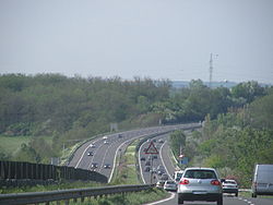


The M7 motorway (Hungarian: M7-es autópálya) is a Hungarian motorway which runs from Budapest towards the Croatian border at Letenye, reaching Székesfehérvár, then Siófok, a town on Lake Balaton, and the city of Nagykanizsa in the southwest of the country.
The motorway connects with the Croatian motorway A4 at Goričan and forms part of the Pan-European corridor Vb, connecting Budapest with Zagreb, the capital of Croatia, and Rijeka, the largest Croatian seaport. Since the completion of the M7 it is possible to travel on motorway from Budapest to the Adriatic Sea, a popular tourist destination for Hungarians.
The last portion of the motorway to the Croatian border, including the Zrinski Bridge on the river Mura, was completed on 22 October 2008. The road's first sections were built in the 1960s and 1970s. The completion of the last sections was undertaken since 2001.
Openings timeline[]
- Budapest – Budaörs (7 km): 1964 - half profile; (this section was extended 2x3 lane in 1978-79)
- Budaörs – Martonvásár (18 km): 1966 - half profile; (this section was extended in 1972; 2x3 lane in 2001)
- Martonvásár – Velence (15 km): 1967 - half profile; (this section was extended in 1973; 2x3 lane in 2001)
- Martonvásár – Székesfehérvár (12 km): 1968 - half profile; (this section was extended in 1973; 2x3 lane in 2001)
- Székesfehérvár – Balatonaliga (33 km): 1970 - half profile; (this section was extended in 1975)
- Balatonaliga – Zamárdi (22 km): 1971 - half profile; (this section was extended in 2001)
- Zamárdi – Balatonkeresztúr with (14,2 km): 2007.08.08.
- Balatonszárszó – Ordacsehi (20 km): 2005.06.
- Ordacsehi – Balatonkeresztúr (25,7 km): 2006.03.27.
- Balatonkeresztúr – Zalakomár (21 km): 2008.06.26.
- Zalakomár – Nagykanizsa (15 km): 2008.08.19.
- Nagykanizsa – Sormás (11,3 km): 2007.08.24.
- Sormás (Eszteregnye) – Becsehely (4,5 km): 2006.12.11.
- Becsehely – Letenye (6,5 km): 2004.09.18.
- Letenye (
 border) with Zrínyi Bridge (800 m): 2008.10.22.
Junctions, exits and rest area[]
This article contains a bulleted list or table of intersections which should be presented in a properly formatted junction table. (November 2021) |
Distance from Zero Kilometre Stone (Adam Clark Square) in Budapest in kilometres.
 The route is full length motorway. The maximum speed limit is 130 km/h, with
  (2x2 lane road with stop lane).
| km | Destinations | Route | Notes | |
|---|---|---|---|---|
| 6 | Budapest, Budaörsi út | Connection to Budapest via Budaörsi út. The road has commons section as M7 motorway, Main road and . The eastern terminus of the motorway | ||
| 7 | Budaörs | Connection to the City of Budapest via Egér út and Budaörs. | ||
| 9 | Drive only towards Budapest. Shopping centers | |||
| 10 | Budaörs-kelet |
Eastern connection to Budaörs via Garibaldi utca. | ||
| 11 | Budaörs-nuygat | Western connection to Budaörs. Shopping centers | ||
| 12 | M7-M1 intersection | Connection to M1 motorway towards to | ||
| 14 | Törökbálint | |||
| 16 | Érd-észak () |
Connection to The northern terminus of European routes E71 concurrency | ||
| 18 | Érd | |||
| 19 | Parking only on the side leading to Budapest | |||
| 23 | Tárnok | Connection to Sóskút and Pusztazámor | ||
| 26 | Tárnok rest area | |||
| 30 | Martonvásár, Gyúró | |||
| 33 | Váli-völgy rest area |
|||
| 42 | Kápolnásnyék, Vereb, Pázmánd | |||
| 45 | Velencei rest area |
|||
| 50 | Pákozd, Sukoró |
|||
| 57 | Székesfehérvár-kelet, Agárd | Eastern connection to Székesfehérvár | ||
| 60 | Székesfehérvár, Dunaújváros |
Connection to Industrial area of Székesfehérvár | ||
| 64 | Székesfehérvár-dél, Sárbogárd (Székesfehérvár bypass) |
Southern part of Székesfehérvár bypass The eastern terminus of European routes E66 | ||
| 70 | Szabadbattyán, Tác-Gorsium |
|||
| 80 | Lepsény, Polgárdi | |||
| 83 | Lepsény rest area | |||
| 90 | M7-M8(710) interchange | Connection to Veszprém towards | ||
| Balatonfüred, Enying | ||||
| 95 | Sóstó rest area | |||
| 98 | Siófok-kelet | Eastern connection to Siófok | ||
| 101 | Szabadi rest area | |||
| Sió (Bridge - 71.6 m) | ||||
| 105 | Siófok-Centrum, Szekszárd | Connection to Central part of Siófok | ||
| 109 | Töreki rest area | |||
| 112 | Siófok-nyugat, Zamárdi-felső, Szántód | Western connection to Siófok, and eastern to Zamárdi, toward to | ||
| 115 | Balatonendréd, Zamárdi-alsó | Connection to Tab | ||
| 121 | Balatonföldvár, Bálványos | |||
| 121-22 | (1872 m) | Longest Bridge in Hungary | ||
| 126 | Balatonszárszó | |||
| 130 | Balatonőszöd, Szólád | |||
| 135 | Balatonszemes, Balatonlelle | Connection to Kaposvár and Szigetvár | ||
| 138 | Balatonlelle rest area | |||
| 143 | Balatonboglár, Lengyeltóti | |||
| 145 | Ordacsehi | Connection to Jankovichtelep (Balatonboglár) | ||
| 150 | Fonyód | Connection to Lengyeltóti and Kaposvár | ||
| 156 | Táska rest area | |||
| 160 | Balatonfenyves, Táska | |||
| 168 | Keresztúr rest area | |||
| 170 | Balatonkeresztúr, Balatonszentgyörgy | Connection to Marcali, Barcs and Zalaegerszeg The northern terminus of European routes E661 | ||
| 175 | Hollád | |||
| 177 | Szegerdő rest area | |||
| 183 | Sávoly, Balatonring | |||
| 191 | Zalakomár, Zalakaros | |||
| 194 | Zalakomár rest area | |||
| 206 | Nagykanizsa-kelet, Kaposvár | Eastern bypass to Nagykanizsa toward to Kaposvár | ||
| 211 | Nagykanizsa-Centrum, Gyékényes, Zalaegerszeg | Connection to Central part of Nagykanizsa or Zalaegerszeg The eastern terminus of European routes E65 | ||
| 215 | Sormás rest area | |||
| 219 | Sormás, Eszteregnye | |||
| 224 | Becsehely | |||
| 232 | Letenye M7-M70 interchange |
Connection to M70 motorway, towards to The eastern terminus of European routes E653 | ||
| 233 | Letenye (H) – Goričan (HR) border crossing | |||
| Mura (Zrínyi Bridge - 216 m) | ||||
- Planned section
Maintenance[]
The operation and maintenance of the road by Hungarian Public Road Nonprofit Pte Ltd Co. This activity is provided by these highway engineers.
- near Martonvásár, kilometre trench 30
- near Balatonvilágos, kilometre trench 90
- near Fonyód, kilometre trench 150
- near Eszteregnye, kilometre trench 219
Payment[]
From 1 February 2015, the motorway can be used instead of the national sticker with the following county stickers:
| Type of vignette | Available section |
|---|---|
| Pest County | between Egér Street junction and Martonvásár (7 km – 30 km) |
| Fejér County | between Pusztazámor and Balatonvilágos (23 km – 90 km) |
| Veszprém County | between Polgárdi and Siófok east (80 km – 98 km) |
| Somogy County | between Balatonvilágos and Zalakomár (90 km – 191 km) |
| Zala County | between Sávoly and Letenye [state border] (183 km – 234 km) |
Toll-free section[]
- From Border of Budapest to Egér Street section (5 km – 7 km) can be used free of charge.
Significant artifacts[]
From Budapest to the Croatian border, the M7 motorway features the following bridges, tunnels or covered cuts:
- Bridge
- Zrinski Bridge (Zrínyi Miklós híd; 216 m or 709 ft) over Mur river
- Viaduct
- (Kőröshegyi völgyhíd; 1,872 m or 6,142 ft) – Longest bridge in Hungary
European Routes[]
| Name | Route | |
| 217 km | ||
| 22 km | ||
See also[]
External links[]
| Wikimedia Commons has media related to Autópálya M7. |
- National Toll Payment Services Plc. (in Hungarian, some information also in English)
- Hungarian Public Road Non-Profit Ltd. (Magyar Közút Nonprofit Zrt.)
- National Infrastructure Developer Ltd.
- Highways in Hungary