MacMasters Beach, New South Wales
| MacMasters Beach Central Coast, New South Wales | |||||||||||||||
|---|---|---|---|---|---|---|---|---|---|---|---|---|---|---|---|
 | |||||||||||||||
| Population | 1,294 (2016 census)[1] | ||||||||||||||
| • Density | 479/km2 (1,241/sq mi) | ||||||||||||||
| Postcode(s) | 2251 | ||||||||||||||
| Area | 2.7 km2 (1.0 sq mi) | ||||||||||||||
| Location |
| ||||||||||||||
| LGA(s) | Central Coast Council | ||||||||||||||
| Parish | Kincumber | ||||||||||||||
| State electorate(s) | Terrigal | ||||||||||||||
| Federal division(s) | Robertson | ||||||||||||||
| |||||||||||||||
MacMasters Beach is a south-eastern suburb of the Central Coast region of New South Wales, Australia on the . It is part of the Central Coast Council local government area
It was named after Allan MacMaster who was one of the first Land owners in this area in 1855 after coming to Australia in 1839 from Scotland. Locals often describe it as having a 'village feel' and strong sense of community.
Gallery[]
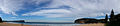
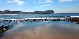
MacMasters Beach panoramic view
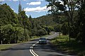
Scenic Road Drive

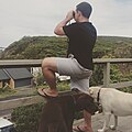
Local wildlife
Beach house lookout


References[]
- ^ Australian Bureau of Statistics (27 June 2017). "MacMasters Beach (State Suburb)". 2016 Census QuickStats. Retrieved 21 December 2017.

Coordinates: 33°29′24″S 151°25′34″E / 33.490°S 151.426°E

This Central Coast geography article is a stub. You can help Wikipedia by . |
Categories:
- Suburbs of the Central Coast (New South Wales)
- Central Coast, New South Wales geography stubs