Maidan Wardak Province
Maidan Wardak
میدان وردګ | |
|---|---|
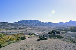 A gathering of people receiving gifts from the Afghan National Army (ANA) during a patrol in the Sayedabad district of Wardak Province in November 2011 | |
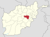
 Map of Afghanistan with Maidan Wardak highlighted | |
| Coordinates (Capital): 34°24′N 68°24′E / 34.4°N 68.4°ECoordinates: 34°24′N 68°24′E / 34.4°N 68.4°E | |
| Country | Afghanistan |
| Capital | Maidan Shar |
| Government | |
| • Governor | Muhammad Arif Shah Jahan |
| Area | |
| • Total | 10,348 km2 (3,995 sq mi) |
| • Land | 10,348 km2 (3,995 sq mi) |
| • Water | 0 km2 (0 sq mi) |
| Population (2021)[1] | |
| • Total | 671,817 |
| • Density | 65/km2 (170/sq mi) |
| Time zone | UTC+4:30 (Afghanistan Time) |
| ISO 3166 code | AF-WAR |
| Main languages | Pashto Hazaragi and Dari |

Maidan Wardak Province[2] (Pashto: میدان وردګ ; Dari: میدان وردگ), also called Maidan Wardag or Wardak, is one of the 34 provinces of Afghanistan, located in the central region of Afghanistan. It is divided into eight districts and has a population of approximately 671,817.[1] The capital of the province is Maidan Shar, while the most populous district in the province is Saydabad District.
In 2021, the Taliban gained control of the province during the 2021 Taliban offensive.
History[]
| History of Afghanistan |
|---|
 |
| Timeline |
| Related historical names of the region |
| Related topics |
|
During the communist times, the people of Wardak never gave significant support to the communist government.[3] Wardak Province was significant during the Civil War in Afghanistan, due to its proximity with Kabul and its agricultural lands. Hezb-e Wahdat had a significant presence in the area. Most of the area was captured by the Taliban around winter 1995.[3] It remains a major Taliban travel route to Kabul with Maidan Shar a target for terror.
The security situation rapidly deteriorated in Wardak in 2008 and 2009. According to a report by Mohammad Osman Tariq Elias, both Logar and Wardak, by the end of 2008, were under de facto Taliban control.[3] As of April 2009, the Ministry of the Interior (Afghanistan) had listed the entire province as "High Risk."[4]
In October 2017, US Forces from elements of the 1st Battalion 87 Infantry Regiment and 10th Special Operations Group launched an offensive to wrest the province from Taliban control.
On 21 January 2019, a Taliban attack on a military base and police training center in the province resulted in 125 NDS officers killed. At least 30 people were reported to be injured. The attack came during a time of intense daily violence throughout the country.[5]

Geography[]
Wardak province is located in the central and eastern region of Afghanistan; bordering Parwan to the northeast, Kabul and Logar to the east, Ghazni to the south and Bamyan to the west. The capital of Wardak province is Maidan Shar, which is located about 35 km from Kabul. Wardak province covers an area of 9,934 km2. It is mountainous like the rest of the country with plains and many valleys, such as the Tangi Valley. The majority of its residents live in rural areas. The most heavily populated areas are along the Kabul–Kandahar Highway. The rest of the province is thinly populated, with villages concentrated in areas with available irrigation and water sources (CSO and UNFPA, 2003). Famous passes include the Unai Pass and the Hajigak Pass.
Economics and industry[]
This section does not cite any sources. (January 2020) |
In terms of industry, one marble factory is working in the province, and there are marble mines in the provincial center and Sayed Abad District although no mining is currently undertaken there due to the government ban. The majority of commercial activity in Maidan Shahr. Wardak is related to trade in agricultural and livestock products, although stone quarrying is also a growing business in the area. The people from Maidan Shahr are also experts in karez cleaning and repair and go to other parts of the country for this purpose. In Wardak, there are many natural resources like petroleum, iron, rubies, and emeralds.
Agriculture is a major source of revenue for 43% of households in Maidan Wardak province. Four-fifths (79%) of rural households own or manage agricultural land or garden plots in the province. However, nearly a quarter (24%) of households in the province derive income from trade and services, and around half (45%) of households earn some income through non-farm related labor.
Education[]

The overall literacy rate in Wardak province is 25%. There are around 251 primary and secondary schools in the province catering for 105,358 students. There are 2909 teachers teaching in these schools.[6]
Demographics[]

As of 2021, the total population of Wardak province is about 671,817.[1] The province is predominantly Pashtun (70%) with Shia Hazaras and Sunni Tajiks making up most of the remainder of the population. The Tajiks live primarily in northern districts of the province while the Hazaras live in the western part of the province. The province also has a small population of Qizilbash who are ethnically Persian and practice Shia Islam.[7][8]
Districts[]
| District | Capital | Population[1] | Area[9] | Notes |
|---|---|---|---|---|
| Chaki Wardak | Chaki Wardak | 97,059 | 1,273 | |
| Day Mirdad | Miran | 35,687 | ||
| Hisa-I-Awali Bihsud | 42,582 | |||
| Jaghatu | 52,585 | Shifted from Ghazni Province in 2005 | ||
| Jalrez | 60,966 | |||
| Markazi Bihsud | Behsud | 137,208 | ||
| Maidan Shar | Maidan Shar | 46,611 | ||
| Nirkh | 65,562 | |||
| Saydabad | Saydabad | 133,5773 | 1,163 |
See also[]
References[]
- ^ Jump up to: a b c d "Estimated Population of Afghanistan 2021-22" (PDF). National Statistic and Information Authority (NSIA). April 2021. Archived (PDF) from the original on June 29, 2021. Retrieved June 21, 2021.
- ^ "Wardak". Office of the President of Afghanistan.
- ^ Jump up to: a b c Elias, Mohammed Osman Tariq (2009). "The Resurgence of the Taliban in Kabul, Logar and Wardak". In Giustozzi, Antonio (ed.). Decoding the New Taliban: Insights from the Afghan Field. Hurst & Company. ISBN 978-1-85065-961-7.
- ^ British Broadcasting Corporation. Afghanistan: Security Map. 19 August 2009. Accessed at: http://news.bbc.co.uk/2/hi/south_asia/8194230.stm Accessed on [28 September 2009]
- ^ Taliban Attack on Afghan Military Base and Police Training Center Kills 12 21 January 2019. Accessed at: [1] Accessed on [21 January 2019]
- ^ "Ministry of Rural Rehabilitation and Development" (PDF). Mrrd.gov.af. 2012-08-04. Retrieved 2012-08-15.
- ^ "Maydan Wardak Province". Understanding War. Retrieved 2013-09-25.
- ^ "Mayden Wardak Provincial Overview". Program for Culture & Conflict Studies. Naval Postgraduate School. Retrieved 24 June 2021.
- ^ Afghanistan Geographic & Thematic Layers
External links[]
| Wikimedia Commons has media related to Wardak Province. |
- Wardak Province by the Institute for the Study of War
- Wardak Province by the Naval Postgraduate School
| show Places adjacent to Maidan Wardak Province |
|---|
| show Authority control |
|---|
- Maidan Wardak Province
- Provinces of Afghanistan
- Hazarajat
- Provinces of the Islamic Republic of Afghanistan