Manyana
| Manyana New South Wales | |||||||||||||||
|---|---|---|---|---|---|---|---|---|---|---|---|---|---|---|---|
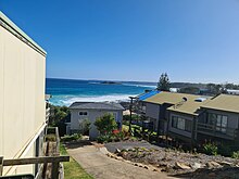
 Manyana Beach and Manyana from Cunjurong Point | |||||||||||||||
 Manyana | |||||||||||||||
| Coordinates | 35°15′S 150°31′E / 35.250°S 150.517°ECoordinates: 35°15′S 150°31′E / 35.250°S 150.517°E | ||||||||||||||
| Population | 521 (2016 census)[1] | ||||||||||||||
| Postcode(s) | 2539 | ||||||||||||||
| Location |
| ||||||||||||||
| LGA(s) | City of Shoalhaven | ||||||||||||||
| County | St Vincent[2] | ||||||||||||||
| Parish | Conjola[2] | ||||||||||||||
| State electorate(s) | South Coast | ||||||||||||||
| Federal division(s) | Gilmore | ||||||||||||||
| |||||||||||||||

Manyana is a small town on the South Coast of New South Wales, Australia in the City of Shoalhaven.[2][3] At the 2016 census, it had a population of 521.[1] Manyana borders with Bendalong and Cunjurong Point.
Manyana
Notes and references[]
- ^ a b Australian Bureau of Statistics (27 June 2017). "Manyana". 2016 Census QuickStats. Retrieved 25 January 2021.

- ^ a b c "Manyana". Geographical Names Register (GNR) of NSW. Geographical Names Board of New South Wales. Retrieved 25 January 2021.
- ^ "Manyana". OpenStreetMap. Retrieved 25 January 2021.
This Shoalhaven geography article is a stub. You can help Wikipedia by . |
Categories:
- Towns in New South Wales
- Towns in the South Coast (New South Wales)
- City of Shoalhaven
- Coastal towns in New South Wales
- Illawarra region geography stubs