Martakert
Martakert / Aghdara
Մարտակերտ / Ağdərə | |
|---|---|
 Martakert in 2002 | |
 Martakert / Aghdara | |
| Coordinates: 40°12′55″N 46°48′46″E / 40.21528°N 46.81278°ECoordinates: 40°12′55″N 46°48′46″E / 40.21528°N 46.81278°E | |
| Country | |
| District | Tartar (de jure) |
| Province | Martakert (de facto) |
| Elevation | 415 m (1,362 ft) |
| Population (2015)[1] | |
| • Total | 4,600 |
| Time zone | UTC+4 (AMT) |


Martakert (Armenian: Մարտակերտ, romanized: Martakert, also Armenian: Մարդակերտ, romanized: Mardakert) or Aghdara (Azerbaijani: Ağdərə ![]() (listen)) is a town de facto in the self-proclaimed Republic of Artsakh as the administrative capital of its Martakert Province, de jure in the Tartar District of Azerbaijan. The town has an ethnic Armenian-majority population, and also had an Armenian majority in 1989.[2]
(listen)) is a town de facto in the self-proclaimed Republic of Artsakh as the administrative capital of its Martakert Province, de jure in the Tartar District of Azerbaijan. The town has an ethnic Armenian-majority population, and also had an Armenian majority in 1989.[2]
Etymology[]
Traditionally the name of the town is interpreted as consisting of the elements mard ("man, person," or in this context "brave") and kert ("built by"), supposedly referring to the inhabitants' reputation for bravery.[3] Other explanations link the name with the word matuṛ ("chapel").[3] The Azerbaijani name for the settlement, Aghdara, translates to "white valley."
History[]

The site of the settlement was historically a part of the Melikdom of Jraberd, one of the Melikdoms of Karabakh. The historical and cultural heritage sites in the town include the 19th-century St. John the Baptist Church, tombs from the 2nd and 1st millennia BC, the 13th-century St. Karapet Church, and cemeteries from the 17th and 19th centuries.[4][5]
In 1918, a battle took place near the town between Ottoman and Armenian forces where the latter emerged victorious.[3]
During the Soviet period, Martakert was the administrative centre of the Martakert District of the Nagorno-Karabakh Autonomous Oblast. It received the status of an urban-type settlement in 1960. During the First Nagorno-Karabakh War (1991–94), Martakert and the surrounding district saw heavy fighting, especially during the Azerbaijani Operation Goranboy and the Mardakert and Martuni Offensives in 1992.[5] The town was captured by Azerbaijani forces on 4 July 1992, forcing Martakert's Armenian population to flee the town.[6] The town was recaptured by Armenian forces on 27 June 1993.[6] Some of the town's natives gradually returned over the years, but many remained in Armenia, Russia, and elsewhere.[6]
The area around the town has been controlled by Artsakh since the end of the war. Martakert was heavily damaged during the First Nagorno-Karabakh War and many of its buildings remain ruined and uninhabited.[6] The enlarged municipal community of Martakert includes the villages of Haykajur, Jraberd, Maralyan Sarov, and Levonarkh. In 2016 and 2020, some clashes along the ceasefire lines took place near Martakert. During the 2020 Nagorno-Karabakh war, the town was bombed by Azerbaijani forces more than once, resulting in civilian deaths.[7][8]
Geography[]
The town is located on the right bank of the Tartar River, between two mountains.[3]
Economy and culture[]
The population mainly works in different state institutions as well as with agriculture. As of 2015, Martakert has a municipality building, a House of Culture, two schools, two kindergartens, a youth centre, 88 commercial enterprises, two factories and a regional hospital.[4]
Demographics[]
The town had 4,576 inhabitants in 1907,[3] 7,074 inhabitants in 1979,[3] 4,262 inhabitants in 2005,[9] and 4,600 inhabitants in 2015.[1]
Gallery[]
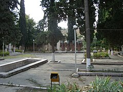
Park and monument in Martakert

Martakert House of Culture
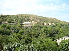
View from the town

One of the main streets in Martakert

Martakert Museum
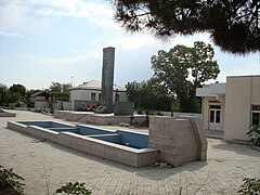
Monument in Martakert


Climate[]
The climate in Martakert is classified as Humid subtropical climate (Cfa) by the Köppen climate classification.[10]
| hideClimate data for Mardakert, Nagorno-Karabakh Republic | |||||||||||||
|---|---|---|---|---|---|---|---|---|---|---|---|---|---|
| Month | Jan | Feb | Mar | Apr | May | Jun | Jul | Aug | Sep | Oct | Nov | Dec | Year |
| Average high °C (°F) | 5.8 (42.4) |
6.6 (43.9) |
10.8 (51.4) |
18.3 (64.9) |
22.4 (72.3) |
27.0 (80.6) |
30.7 (87.3) |
29.2 (84.6) |
25.3 (77.5) |
18.4 (65.1) |
12.5 (54.5) |
8.1 (46.6) |
17.9 (64.3) |
| Average low °C (°F) | −1.7 (28.9) |
−1.0 (30.2) |
2.3 (36.1) |
8.1 (46.6) |
12.5 (54.5) |
16.7 (62.1) |
20.0 (68.0) |
19.0 (66.2) |
15.4 (59.7) |
9.7 (49.5) |
4.8 (40.6) |
0.6 (33.1) |
8.9 (48.0) |
| Average precipitation mm (inches) | 15 (0.6) |
23 (0.9) |
34 (1.3) |
45 (1.8) |
71 (2.8) |
64 (2.5) |
31 (1.2) |
26 (1.0) |
27 (1.1) |
45 (1.8) |
28 (1.1) |
17 (0.7) |
426 (16.8) |
| Source: http://en.climate-data.org/location/21905/ | |||||||||||||
Twin towns – sister cities[]
Partnership agreement:
 Bourj Hammoud, Lebanon. In May 2018, representatives of the Artsakh city of Martakert and the Lebanese town of Bourj Hammoud signed a Memorandum of Cooperation. The memorandum states that aiming at the establishment of social, economic, tourism, and cultural relations between the two towns as well as realizing that cooperation between the towns can contribute to the strengthening of regional stability and peace.[12]
References[]
- ^ Jump up to: a b "Figures" (PDF). stat-nkr.am. 2015.
- ^ Андрей Зубов. "Андрей Зубов. Карабах: Мир и Война". drugoivzgliad.com.
- ^ Jump up to: a b c d e f Hakobyan, Tadevos Kh.; Melik-Bakhshyan, Stepan T.; Barseghyan, Hovhannes Kh. (1986). Հայաստանի և հարակից շրջանների տեղանունների բառարան [Dictionary of toponymy of Armenia and adjacent territories] (in Armenian). 1. Yerevan: Yerevan State University Publishing House. p. 208.
- ^ Jump up to: a b Hakob Ghahramanyan. "Directory of socio-economic characteristics of NKR administrative-territorial units (2015)".
- ^ Jump up to: a b Kiesling, Brady; Kojian, Raffi (2019). Rediscovering Armenia: An in-depth inventory of villages and monuments in Armenia and Artsakh (3rd ed.). Armeniapedia Publishing.
- ^ Jump up to: a b c d Hakobyan, Tatul (27 June 2021). "Մարտակերտի ազատագրումը. հունիս 27, 1993թ" [The liberation of Martakert, June 27, 1993]. www.aniarc.am (in Armenian). ANI Armenian Research Center. Retrieved 29 June 2021.
- ^ "Ադրբեջանի ռազմական ինքնաթիռը ռմբակոծել է Մարտակերտը, կա երեք զոհ. Վահրամ Պողոսյան". «Ազատ Եվրոպա/Ազատություն» ռադիոկայան (in Armenian). Retrieved 2021-06-29.
- ^ "Մարտակերտը ռմբակոծվում է, կիրառվում է ռազմական ավիացիա, հայտնում է ԱԻՊԾ-ն". «Ազատ Եվրոպա/Ազատություն» ռադիոկայան (in Armenian). Retrieved 2021-06-29.
- ^ "The Results of the 2005 Census of the Nagorno-Karabakh Republic" (PDF). National Statistic Service of the Republic of Artsakh.
- ^ http://en.climate-data.org/location/21905/
- ^ Official page of Vagarshapat city
- ^ Karabakh’s Martakert, Lebanon’s Bourj Hammoud sign memorandum of cooperation, news.am 18. May 2018.
External links[]
| Wikimedia Commons has media related to Aghdara. |
- World Gazetteer: Azerbaijan[dead link] – World-Gazetteer.com
- Martakert at GEOnet Names Server
- A short documentary about the town on YouTube


- Populated places in Tartar District
- Azerbaijani administrative divisions of Artsakh
- Cities and towns in Azerbaijan
- Populated places in Martakert province
- Cities and towns in the Republic of Artsakh
- Populated places in the Republic of Artsakh
- Nagorno-Karabakh