Chartar
Chartar
Ճարտար | |
|---|---|
| Çartar | |
 | |
 Chartar | |
| Coordinates: 39°45′29″N 47°00′58″E / 39.75806°N 47.01611°ECoordinates: 39°45′29″N 47°00′58″E / 39.75806°N 47.01611°E | |
| Country (de facto) | |
| • Province | Martuni |
| Country (de jure) | |
| • District | Khojavend |
| Population (2015)[1] | |
| • Total | 4,100 |
| Time zone | UTC+4 (AMT) |


Chartar (Armenian: Ճարտար; Azerbaijani: Çartar) is a town de facto in the Martuni Province of the self-proclaimed Republic of Artsakh, de jure in the Khojavend District of Azerbaijan. The town has an ethnic Armenian-majority population, and also had an Armenian majority in 1989.[2]
History[]

The town of Chartar was created out of a merger of the four villages of Ghuze Chartar, Ghuze Kaler, Gyune Chartar and Gyune Kaler.[3]
During the Soviet period, the town was a part of the Martuni District of the Nagorno-Karabakh Autonomous Oblast.
Historical and cultural heritage[]
Historical heritage sites in and around Chartar include Chartar Fortress (from between the 3rd and 1st centuries BCE), the Kohak Church (from between the 10th and 13th centuries), the St. Yeghishe Church from 1655, the St. Amenaprkich Church founded in 1787, and the 19th-century St. George's Church.[3][4]
Economy and culture[]
The population is mainly engaged in agriculture and animal husbandry. As of 2015, the village has a municipal building, a house of culture, five schools, an art school, two kindergartens, nine shops, a hospital, and a medical centre.[4]
Demographics[]
Chartar had 3,951 inhabitants in 2005 (with the census divided between "Chartar" with 2,213 inhabitants and "Ghuze Chartar" with 1,738 inhabitants),[5] and 4,100 inhabitants in 2015.[1]
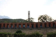
Gallery[]

Chartar House of Culture (also called the "Sports and Cultural Palace" of Chartar)
WWII monument
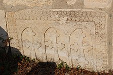
13th-century khachkar near the St. Yeghishe Church

Tombstone near the St. Yeghishe Church

A view of the town

Monument to the fallen in the First Nagorno-Karabakh War

Chartar Fortress

St. Yeghishe Church interior


References[]
- ^ a b "Figures" (PDF). stat-nkr.am. 2015.
- ^ Андрей Зубов. "Андрей Зубов. Карабах: Мир и Война". drugoivzgliad.com.
- ^ a b Kiesling, Brady; Kojian, Raffi (2019). Rediscovering Armenia: An in-depth inventory of villages and monuments in Armenia and Artsakh (3rd ed.). Armeniapedia Publishing.
- ^ a b Hakob Ghahramanyan. "Directory of socio-economic characteristics of NKR administrative-territorial units (2015)".
- ^ "The Results of the 2005 Census of the Nagorno-Karabakh Republic" (PDF). National Statistic Service of the Republic of Artsakh.
External links[]
| Wikimedia Commons has media related to Chartar. |
Capital: Martuni | ||
| Urban communities |  | |
| Rural communities | ||
| Not under Artsakh control |
| |

- Populated places in Martuni Province
- Populated places in Khojavend District
- Cities and towns in the Republic of Artsakh