Ağcakənd, Khojavend
Aghjakend / Khandzadzor
Ağcakənd / Խանձաձոր | |
|---|---|
 | |
 Aghjakend / Khandzadzor | |
| Coordinates: 39°29′49″N 46°52′42″E / 39.49694°N 46.87833°ECoordinates: 39°29′49″N 46°52′42″E / 39.49694°N 46.87833°E | |
| Country | |
| District | Khojavend |
| Elevation | 1,391 m (4,564 ft) |
| Population (2015)[1] | |
| • Total | 122 |
| Time zone | UTC+4 (AZT) |
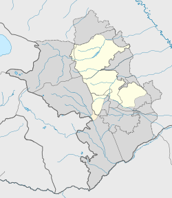
Ağcakənd (Aghjakend) or Khandzadzor (Armenian: Խանձաձոր) is a village in the Khojavend District of Azerbaijan, in the disputed region of Nagorno-Karabakh. The village had an ethnic Armenian-majority population prior to the 2020 Nagorno-Karabakh war, and also had an Armenian majority in 1989.[2]
History[]
During the Soviet period, the village was a part of the Hadrut District of the Nagorno-Karabakh Autonomous Oblast.
It was captured by Armenian forces on 29 August 1993 and was made part of Hadrut Province of the self-proclaimed Republic of Artsakh. It was recaptured by Azerbaijani Armed Forces on 20 October 2020.[3]
References[]
- ^ Hakob Ghahramanyan. "Directory of socio-economic characteristics of NKR administrative-territorial units (2015)".
- ^ Андрей Зубов. "Андрей Зубов. Карабах: Мир и Война". drugoivzgliad.com.
- ^ https://qafqazinfo.az/news/detail/bu-kendler-de-azad-edildi-prezident-elan-etdi-302521
External links[]
| Wikimedia Commons has media related to Ağcakənd, Khojavend. |
Categories:
- Populated places in Hadrut Province
- Nagorno-Karabakh
- Former Armenian inhabited settlements


