Martuni Province
This article needs additional citations for verification. (April 2018) |
Martuni
Մարտունի | |
|---|---|
| Xocəvənd | |
 | |
| Capital | Martuni |
| Government | |
| • Governor | Nelson Soghomonyan |
| Area | |
| • Total | 951 km2 (367 sq mi) |
| Area rank | Ranked 6th |
| Population (2015) | |
| • Total | 24,300 [1] |
| • Rank | Ranked 2nd |
| Website | Martuni Region |
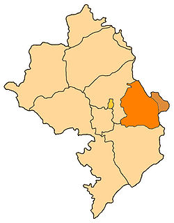
Martuni Province (Armenian: Մարտունու շրջան) is a province of the separatist Republic of Artsakh, de jure part of the Republic of Azerbaijan.
History[]
The territory was formed from the Soviet-era raion of Martuni District within the former Nagorno-Karabakh Autonomous Oblast. The eastern part of that district is under the control of the Azerbaijan. Martuni Province consists of the branch of the former Oblast which juts out farthest to the east, almost reaches Stepanakert on the west, and goes a little past Karmir Shuka on the south. The western half has many hills and small mountains, full of small villages, while the eastern half is very flat, with fewer villages, and the larger regional center of Martuni. Historically, this area was also known as Myus Haband and Varand. The Martuni Province has 35 rural communities and one urban community.[citation needed]
In 1991, the Azerbaijani parliament, with the Law on Abolishment of Nagorno-Karabakh Autonomous Oblast, abolished the Martuni District and forcibly consolidated its territory into the neighboring Khojavend District.[2]
Sites of interest[]

- Amaras Monastery, one of the oldest monasteries in the former Kingdom of Armenia.
Coordinates: 39°47′43″N 47°06′47″E / 39.7953°N 47.1131°E
References[]
- ^ http://stat-nkr.am/files/publications/2015/LXH_tverov_2015.pdf
- ^ "AZƏRBAYCAN RESPUBLIKASININ DAĞLIQ QARABAĞ MUXTAR VILAYƏTINI LƏĞV ETMƏK HAQQINDA Azərbaycan Respublikasının Qanunu". Archived from the original on 2012-03-26. Retrieved 2012-08-02.
- Regions of the Republic of Artsakh
- Martuni (province)

