Megathrust earthquake
| Part of a series on |
| Earthquakes |
|---|
 |
|
Megathrust earthquakes occur at convergent plate boundaries, where one tectonic plate is forced underneath another. The earthquakes are caused by slip along the thrust fault that forms the contact between the two plates. These interplate earthquakes are the planet's most powerful, with moment magnitudes (Mw) that can exceed 9.0.[1][2] Since 1900, all earthquakes of magnitude 9.0 or greater have been megathrust earthquakes.[3]
The thrust faults responsible for megathrust earthquakes lie at the bottom of oceanic trenches, and the earthquakes can abruptly displace the sea floor over a large area. As a result, megathrust earthquakes often generate tsunamis that are considerably more destructive than the earthquakes themselves. Teletsunamis can cross ocean basins to devastate areas far from the original earthquake.
Terminology and mechanism[]
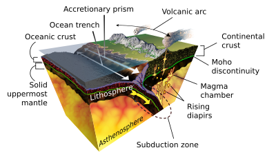
The term megathrust refers to an extremely large thrust fault, typically formed at the plate interface along a subduction zone, such as the Sunda megathrust.[4][5] However, the term is also occasionally applied to large thrust faults in continental collision zones, such as the Himalayan megathrust.[6] A megathrust fault can be 1,000 kilometers (600 mi) long.[7]

A thrust fault is a type of reverse fault, in which the rock above the fault is displaced upwards relative to the rock below the fault. This distinguishes reverse faults from normal faults, where the rock above the fault is displaced downwards, or strike-slip faults, where the rock on one side of the fault is displaced horizontally with respect to the other side. Thrust faults are distinguished from other reverse faults because they dip at a relatively shallow angle, typically less than 45°,[8] and show large displacements.[9][10] In effect, the rocks above the fault have been thrust over the rocks below the fault. Thrust faults are characteristic of areas where the Earth's crust is being compressed by tectonic forces.[11]
Megathrust faults occur where two tectonic plates collide. When one of the plates is composed of oceanic lithosphere, it dives beneath the other plate (called the overriding plate) and sinks into the Earth's mantle as a slab. The contact between the colliding plates is the megathrust fault, where the rock of the overriding plate is displaced upwards relative to the rock of the descending slab.[5] Friction along the megathrust fault can lock the plates together, and the subduction forces then build up strain in the two plates. A megathrust earthquake takes place when the fault ruptures, allowing the plates to abruptly move past each other to release the accumulated strain energy.[7]
Occurrence and characteristics[]
Megathrust earthquakes are almost exclusive to tectonic subduction zones and are often associated with the Pacific and Indian Oceans.[5] These subduction zones are not only responsible for megathrust earthquakes but are also largely responsible for the volcanic activity associated with the Pacific Ring of Fire.[12]
Since the earthquakes associated with these subduction zones deform the ocean floor, they often generate a significant series of tsunami waves.[13] Subduction zone earthquakes are also known to produce intense shaking and ground movements for significant periods of time that can last for up to 3-5 minutes.[14]
In the Indian Ocean region, the Sunda megathrust is located where the Indo-Australian Plate is subducting under the Eurasian Plate and extends 5,500 kilometres (3,400 mi) off the coasts of Myanmar, Sumatra, Java and Bali before terminating off the northwestern coast of Australia. This subduction zone was responsible for the 2004 Indian Ocean earthquake and tsunami.[15]
In Japan, the Nankai megathrust under the Nankai Trough is responsible for Nankai megathrust earthquakes and associated tsunamis.[16]
In North America, the Juan de Fuca Plate is subducting under the North American Plate creating the Cascadia subduction zone which stretches from mid Vancouver Island, British Columbia to Northern California. This subduction zone was responsible for the 1700 Cascadia earthquake.[17] The Aleutian Trench, of the southern coast of Alaska, and the Aleutian Islands, where the North American Plate overrides the Pacific Plate, has generated many major earthquakes throughout history, several of which generated Pacific-wide tsunamis,[18] including the 1964 Alaska earthquake; at magnitude 9.2, it remains the largest recorded earthquake in North America, and the second-largest earthquake instrumentally recorded in the world.[19]
The largest recorded megathrust earthquake was the 1960 Valdivia earthquake, estimated magnitude 9.4–9.6, centered off the coast of Chile along the Peru-Chile trench, where the Nazca Plate is subducting under the South American Plate.[20] This megathrust region has regularly generated extremely large earthquakes historically, the largest megathrust event within the last 20 years being the magnitude 8.8 2010 Chile earthquake.[21]
A study reported in 2016 found that the largest megathrust quakes are associated with downgoing slabs with the shallowest dip, so-called flat slab subduction.[22]
Compared with other earthquakes of similar magnitude, megathrust earthquakes have a longer duration and slower rupture velocities. The largest megathrust earthquakes occur in subduction zones with thick sediments, which may allow a fault rupture to propagate for great distances unimpeded.[5]
See also[]
References[]
- ^ Meier, M.-A.; Ampuero, J. P.; Heaton, T. H. (22 September 2017). "The hidden simplicity of subduction megathrust earthquakes". Science. 357 (6357): 1277–1281. Bibcode:2017Sci...357.1277M. doi:10.1126/science.aan5643. PMID 28935803. S2CID 206660652.
- ^ "Questions and Answers on Megathrust Earthquakes". Natural Resources Canada. Government of Canada. 19 October 2018. Retrieved 23 September 2020.
- ^ Johnston, Arch C.; Halchuk, Stephen (June–July 1993), "The seismicity data base for the Global Seismic Hazard Assessment Program", Annali di Geofisica, 36 (3–4): 133–151, pp. 140, 142 et seq.
- ^ Park, J.; Butler, R.; Anderson, K.; et al. (2005). "Performance Review of the Global Seismographic Network for the Sumatra-Andaman Megathrust Earthquake". Seismological Research Letters. 76 (3): 331–343. doi:10.1785/gssrl.76.3.331. ISSN 0895-0695.
- ^ a b c d Bilek, Susan L.; Lay, Thorne (1 August 2018). "Subduction zone megathrust earthquakes". Geosphere. 14 (4): 1468–1500. Bibcode:2018Geosp..14.1468B. doi:10.1130/GES01608.1. S2CID 133629102.
- ^ Elliott, J.R.; Jolivet, R.; González, P. J.; Avouac, J.-P.; Hollingsworth, J.; Searle, M. P.; Stevens, V.L. (February 2016). "Himalayan megathrust geometry and relation to topography revealed by the Gorkha earthquake" (PDF). Nature Geoscience. 9 (2): 174–180. Bibcode:2016NatGe...9..174E. doi:10.1038/ngeo2623.
- ^ a b "Cascadia Subduction Zone". Pacific Northwest Seismic Network. Retrieved 7 October 2021.
- ^ "Earthquake Glossary – dip slip". Earthquake Hazards Program. U.S. Geological Survey.
- ^ Fossen, Haakon (2016). Structural geology (Second ed.). Cambridge, United Kingdom: Cambridge University Press. pp. 485, 488, 491. ISBN 9781107057647.
- ^ "Tsunami Terminology". The National Tsunami Hazard Mitigation Program History, 1995–2005. Pacific Marine Environmental Laboratory. Archived from the original on 2011-02-25.
- ^ Fossen 2016, p. 356.
- ^ "What is the Ring of Fire?". Ocean exploration. National Ocean and Atmospheric Administration. Retrieved 7 October 2021.
- ^ Maksymowicz, A.; Chadwell, C. D.; Ruiz, J.; Tréhu, A. M.; Contreras-Reyes, E.; Weinrebe, W.; Díaz-Naveas, J.; Gibson, J. C.; Lonsdale, P.; Tryon, M. D. (April 2017). "Coseismic seafloor deformation in the trench region during the Mw8.8 Maule megathrust earthquake". Scientific Reports. 7 (1): 45918. Bibcode:2017NatSR...745918M. doi:10.1038/srep45918. PMC 5381107. PMID 28378757.
- ^ Megawati, K.; Pan, T.-C. (1 April 2009). "Regional Seismic Hazard Posed by the Mentawai Segment of the Sumatran Megathrust". Bulletin of the Seismological Society of America. 99 (2A): 566–584. Bibcode:2009BuSSA..99..566M. doi:10.1785/0120080109.
- ^ Sieh, Kerry (March 2007). "The Sunda megathrust: past, present and future". Journal of Earthquake and Tsunami. 01 (1): 1–19. doi:10.1142/S179343110700002X.
- ^ Hirahara, K.; Kato N.; Miyatake T.; Hori T.; Hyodo M.; Inn J.; Mitsui N.; Sasaki T.; Miyamura T.; Nakama Y.; Kanai T. (2004). "Simulation of Earthquake Generation Process in a Complex System of Faults" (PDF). Annual Report of the Earth Simulator Center April 2004 - March 2005. pp. 121–126. Retrieved 2009-11-14.
- ^ "A Major Earthquake in the Pacific Northwest Looks Even Likelier". The Atlantic. August 16, 2016.
- ^ Witter, Rob; Briggs, Rich; Engelhart, Simon E.; Gelfenbaum, Guy; Koehler, Rich D.; Nelson, Alan; Selle, SeanPaul La; Corbett, Reide; Wallace, Kristi (1 May 2019). "Evidence for frequent, large tsunamis spanning locked and creeping parts of the Aleutian megathrust". GSA Bulletin. 131 (5–6): 707–729. Bibcode:2019GSAB..131..707W. doi:10.1130/B32031.1. S2CID 134362013.
- ^ Ali, Syed Tabrez; Freed, Andrew M. (November 2010). "Contemporary deformation and stressing rates in Southern Alaska: Deformation and stressing rates in S. Alaska". Geophysical Journal International. 183 (2): 557–571. doi:10.1111/j.1365-246X.2010.04784.x.
- ^ Ojeda, Javier; Ruiz, Sergio; del Campo, Francisco; Carvajal, Matías (1 May 2020). "The 21 May 1960 Mw 8.1 Concepción Earthquake: A Deep Megathrust Foreshock That Started the 1960 Central-South Chilean Seismic Sequence". Seismological Research Letters. 91 (3): 1617–1627. doi:10.1785/0220190143. S2CID 216347638.
- ^ "Historic World Earthquakes". Earthquake.usgs.gov. United States Geological Survey. 23 November 2009. Archived from the original on 30 January 2016. Retrieved 27 February 2010.
- ^ Bletery, Quentin; Thomas, Amanda M.; Rempel, Alan W.; Karlstrom, Leif; Sladen, Anthony; De Barros, Louis (2016-11-24). "Fault curvature may control where big quakes occur, Eurekalert 24-NOV-2016". Science. 354 (6315): 1027–1031. Bibcode:2016Sci...354.1027B. doi:10.1126/science.aag0482. PMID 27885027. Retrieved 2018-06-05.
Further reading[]
External links[]
- ^ Gutscher, M.-A.; Baptista, M.A.; Miranda, J.M. (2006). "The Gibraltar Arc seismogenic zone (part 2): Constraints on a shallow east dipping fault plane source for the 1755 Lisbon earthquake provided by tsunami modeling and seismic intensity". Tectonophysics. 426 (1–2): 153–166. Bibcode:2006Tectp.426..153G. doi:10.1016/j.tecto.2006.02.025. ISSN 0040-1951.
- Megathrust earthquakes
- Plate tectonics
- Types of earthquake
- Tsunami