Mevaseret Zion
Mevaseret Zion
מְבַשֶּׂרֶת צִיּוֹן | |
|---|---|
Local council | |
| Hebrew transcription(s) | |
| • ISO 259 | Mbaśśert Çiyon |
| • Also spelled | Mevasseret Ziyyon (official) |
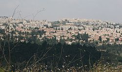 View of Mevaseret from Rekhes Halilim | |
 Coat of arms | |
 Mevaseret Zion | |
| Coordinates: 31°48′N 35°9′E / 31.800°N 35.150°ECoordinates: 31°48′N 35°9′E / 31.800°N 35.150°E | |
| Country | |
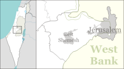
| District | |
| Founded | 1951 |
| Government | |
| • Head of Municipality | Yoram Shimon |
| Area | |
| • Total | 6,390 dunams (6.39 km2 or 2.47 sq mi) |
| Population (2019)[1] | |
| • Total | 24,052 |
| • Density | 3,800/km2 (9,700/sq mi) |
| Name meaning | Herald of Zion (from Isaiah 40:9) |


Mevaseret Zion (Hebrew: מְבַשֶּׂרֶת צִיּוֹן, literal meaning: Herald of Zion – Jerusalem) is a suburb of Jerusalem[2] with the administrative status of a local council. Mevaseret Zion is composed of two distinct older townships, Maoz Zion and Mevaseret Yerushalayim, under the jurisdiction of one local council. The newer neighborhoods of Mevaseret Zion were not part of either settlement.
Mevaseret Zion is located on a mountain ridge 750 meters above sea level, on the outskirts of Jerusalem. It is ten kilometers from the city, straddling both sides of the Jerusalem–Tel Aviv highway. In 2019 it had a population of 24,409, spread over 15 neighborhoods. It is the wealthiest municipality per capita in the Jerusalem District. Mevaseret Zion's current Mayor is Yoram Shimon.
History[]
Castel area[]
Due to its strategic location, settlement in the area of Mevasseret Zion goes back to antiquity. The Romans built a fortress there, known as Castellum.[citation needed] On the ruins of this fortress, the Crusaders built a castle, Castellum Belveer, of which no trace remains.[3] Belveer is mentioned in a letter from Eraclius, Patriarch of Jerusalem, dated September 1187, in which he describes the slaughter of Christians "by the sword of Mafumetus the Unbeliever and his evil worshipper Saladin" and the Arab conquest of the town, which was renamed al-Qastal.[4]
During the British Mandate of Palestine, the British referred to this district as "The Castle". The Arabs called it "al-Qastal", pronouncing the "t." The Jews called it "HaCástel" ("the Cástel").
In the 1948 Palestine War, battles took place here as Arabs and Jews fought for control of al-Qastal, which overlooked the main Tel Aviv-Jerusalem highway. Al-Qastal exchanged hands several times in the course of the fighting. The tides turned when the Arab commander Abd al-Qadir al-Husayni was killed. Many of the Arabs left their positions to attend al-Husayni's funeral at the Al-Aqsa Mosque on Friday, April 9. That same day, al-Qastal fell to the Yishuv forces, virtually unopposed.[5]

Maoz Zion[]
Maoz Zion ("Stronghold of Zion") was established in 1951 to house new immigrants from Iraq, Kurdistan, North Africa and Iran who had been living in a ma'abara, or transit camp, at the foot of the Castel hill. Many were employed at the nearby Solel Boneh stone quarry.
Mevasseret Yerushalayim[]
Mevasseret Yerushalayim was established east of Ma'oz Zion in 1956 by Jewish immigrants from North Africa. It was located on a ridge near the armistice line, north of Motza. The residents worked in the fruit orchards in the Arazim Valley.[6]
Unified local council[]
In 1963, Maoz Zion and Mevasseret Yerushalayim formed a joint local council, which was called Mevasseret Zion. The source of the name comes from the Book of Isaiah: "על הר גבוה עלי לך מבשרת ציון" - "Ascend a lofty mountain, O herald of joy to Zion" (Isaiah 40:9).[7]

Institutions and landmarks[]
The Har'el shopping mall is located at the entrance to Mevasseret Zion, near the Har'el interchange. The mall serves the residents of Mevasseret Zion, Maoz Zion, the surrounding communities, as well as travelers on Route 1. The shopping mall which includes some 80 businesses has been joined by the Jerusalem Mall on the other side of the highway at the entrance of Maoz Zion. Businesses included between both malls include Golf, s.wear, Magnolia Jewelers, Castro, Renaur and many others.The world's first kosher McDonald's opened there in 1995. [8] In addition to numerous Orthodox congregations Mevasseret Zion also has a Reform congregation, Kehillat Mevasseret Zion, founded in 1993.
Education[]
Mevasseret Zion has 3 secular grade schools, one junior-high school and a high school, "Tichon Har'el". It also holds two religious schools.
Yeshivat Sha'arei Mevasseret Zion is located in Mevasseret Zion. It includes a kollel, mostly catering to adult Israeli men, and a gap year program for students from English-speaking high schools.
Archaeology[]
In April–May 2003, an archaeological salvage dig carried out on Nahal Sorek Street in Mevasseret Zion unearthed an ancient burial cave dating from the mid-Second Temple period.[9]
The ruins of a medieval structure, Khirbet Beit Mizza, are located in Mevasseret Zion,[10] and were believed by some scholars to be the site of the biblical town of Mozah mentioned in the Book of Joshua (Joshua 18:26),[11] until recent excavations made clear that Mozah of the Hebrew Bible is to be identified with nearby Khirbet Mizzah, the Arabic name by which the ruins of the Arab village of Qaluniya are known, which were hence named in Modern Hebrew as Tel Moza.[12]
Sports[]
Mevasseret Zion holds both a soccer team and a basketball team, both playing for low leagues.
Hapoel Mevasseret Zion, plays at Israel's Liga Gimel, Israel's 5th league. Started as Hapoel Mevasseret Zion and then united with Ironi Abu Ghosh, and became the first Israeli team mixed from an Arab village and a Jewish town. In 2007 Mevasseret-Abu Ghosh was united with Hapoel Katamon, and then separated again. The team is built of Arab and Jewish players, and participated in international friendly tournaments for peace. The team plays in local soccer field called "Hamigrash Hayarok" Which means in Hebrew, the green field. The capacity is about 200 people.
Hapoel Mevasseret Zion basketball plays also for Liga Bet. The team plays in the local basketball court with a capacity of 300 seats.
Notable residents[]

- Rachel Adato
- Aharon Appelfeld
- Shlomo Bentin
- Charlie Biton
- Ran Cohen
- Martin van Creveld
- David Grossman
- Tzachi Hanegbi
- Mickey Levy
- Josh Reinstein[citation needed]
- Amnon Shashua
- Yuval Steinitz[13]
- Matan Vilnai
Sister cities[]
 White Plains, New York (2004)[14]
 Sankt Augustin, Germany (2001).
- Calabasas, California (2012).[15]
See also[]
References[]
- ^ "Population in the Localities 2019" (XLS). Israel Central Bureau of Statistics. Retrieved 16 August 2020.
- ^ See Positions on Jerusalem
- ^ Pringle, Denys (1997). Qastal (R15). Secular buildings in the Crusader Kingdom of Jerusalem: an archaeological gazetteer. Cambridge: Cambridge University Press. p. 118.
No trace of any Frankish structures, despite contrary claims.
- ^ Letters from the East: Crusaders, Pilgrims and Settlers in the 12th-13th Centuries, Keith Bate, Malcolm Barber, A.K. Bate
- ^ Institute of Jerusalem Studies Archived 2008-03-05 at the Wayback Machine
- ^ Encyclopaedia Judaica, "Mevasseret Zion", p. 1453
- ^ Vilnay, Zev, Rachel and Oren: The Vilnay Guide to Israel. A new Millenium edition, Vol 1: Jerusalem, Beersheba and Southern Israel, Atlit 1999, p. 208, ISBN 965-90269-0-0
- ^ Observant have little appetite for Israel's kosher McDonald's
- ^ Israel Antiquities Authority
- ^ Domestic Settings: Sources on Domestic Architecture and Day-to-Day Activities in the Crusader States, Adrian J. Boas
- ^ Richard R. Losch (2005). The Uttermost Part of the Earth: A Guide to Places in the Bible. Grand Rapids, Michigan: Eerdmans. ISBN 9780802828057. Retrieved 25 May 2018.
- ^ Israel Finkelstein, Yuval Gadot, Mozah, Nephtoah and royal estates in the Jerusalem highlands, in Semitica et Cassica. International Journal of Oriental and Mediterranean Studies, Vol. VIII 2015, Brepols Publishers, pp. 227-8
- ^ Birnbaum, Ben (5 November 2013). "A Loyal Ally to Netanyahu Moves to Center Stage as Iranian Talks Heat Up". Tablet. Retrieved 11 December 2019.
- ^ info@yiwp.org ** 135 Old Mamaroneck Road, White Plains, NY 10606 ** 914-683-YIWP
- ^ ** Calabasas Sister Cities - Mevasseret Zion **
External links[]
- Municipality website (in Hebrew)
- Harel High School website (in Hebrew)
- Notes on an Iron Age four sheqel scale weight from Mevasseret Yerushalayim
| hide | ||
|---|---|---|
| Cities | ||
| Local councils | ||
| Regional councils | ||
| See also: | ||
| ||
- Jerusalem District
- Local councils in Jerusalem District
- Populated places established in 1951
- 1951 establishments in Israel