Midland, Pennsylvania
Midland, Pennsylvania | |
|---|---|
| Borough of Midland | |
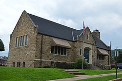 Carnegie Library | |
 Location in Beaver County and the U.S. state of Pennsylvania. | |
| Coordinates: 40°38′18″N 80°27′09″W / 40.63833°N 80.45250°WCoordinates: 40°38′18″N 80°27′09″W / 40.63833°N 80.45250°W | |
| Country | United States |
| State | Pennsylvania |
| County | Beaver |
| Incorporated | 1906 |
| Government | |
| • Type | Borough Council |
| Area | |
| • Total | 1.99 sq mi (5.16 km2) |
| • Land | 1.81 sq mi (4.69 km2) |
| • Water | 0.18 sq mi (0.47 km2) |
| Elevation | 797 ft (243 m) |
| Population (2010) | |
| • Total | 2,635 |
| • Estimate (2019)[2] | 2,469 |
| • Density | 1,364.84/sq mi (526.96/km2) |
| Time zone | UTC-5 (Eastern (EST)) |
| • Summer (DST) | UTC-4 (EDT) |
| Zip code | 15059 |
| Area code(s) | 724 |
| FIPS code | 42-49184 |

Midland is a borough located along the Ohio River in Beaver County, Pennsylvania, United States. As of the 2010 census, the borough population was 2,635.[3]
Geography[]
Midland is located in western Beaver County at 40°38′18″N 80°27′9″W / 40.63833°N 80.45250°W (40.638273, -80.452455).[4] According to the United States Census Bureau, the borough has a total area of 2.0 square miles (5.2 km2), of which 1.8 square miles (4.7 km2) is land and 0.19 square miles (0.5 km2), or 9.13%, is water.[3]
Pennsylvania Route 68 (Midland Avenue) is the main street through the community, leading east into Industry and west to Glasgow and the Ohio border. Pennsylvania Route 168 joins PA-68 along Midland Avenue through the center of town, but splits off to the south to cross the Ohio River via the Shippingport Bridge, and climbs out of the river valley to the north via Fairview Road.
Surrounding and adjacent neighborhoods[]
Midland has two land borders with Industry to the northeast and Ohioville to the northwest. Across the Ohio River to the southeast, Midland runs mostly adjacent with Greene Township with a short alignment with Shippingport to the southwest.
Demographics[]
| Historical population | |||
|---|---|---|---|
| Census | Pop. | %± | |
| 1910 | 1,244 | — | |
| 1920 | 5,452 | 338.3% | |
| 1930 | 6,007 | 10.2% | |
| 1940 | 6,373 | 6.1% | |
| 1950 | 6,491 | 1.9% | |
| 1960 | 6,425 | −1.0% | |
| 1970 | 5,271 | −18.0% | |
| 1980 | 4,310 | −18.2% | |
| 1990 | 3,321 | −22.9% | |
| 2000 | 3,137 | −5.5% | |
| 2010 | 2,635 | −16.0% | |
| 2019 (est.) | 2,469 | [2] | −6.3% |
| Sources:[5][6][7] | |||
As of the census[6] of 2000, there were 3,137 people, 1,424 households, and 817 families residing in the borough. The population density was 1,537.1 people per square mile (593.7/km²). There were 1,651 housing units at an average density of 809.0 per square mile (312.5/km²). The racial makeup of the borough was 75.71% White, 20.85% African American, 0.45% Native American, 0.89% from other races, and 2.10% from two or more races. Hispanic or Latino of any race were 3.70% of the population.
There were 1,424 households, out of which 24.6% had children under the age of 18 living with them, 34.1% were married couples living together, 18.1% had a female householder with no husband present, and 42.6% were non-families. 38.7% of all households were made up of individuals, and 19.5% had someone living alone who was 65 years of age or older. The average household size was 2.19 and the average family size was 2.91.
In the borough the population was spread out, with 23.2% under the age of 18, 8.2% from 18 to 24, 25.8% from 25 to 44, 19.0% from 45 to 64, and 23.8% who were 65 years of age or older. The median age was 40 years. For every 100 females, there were 82.6 males. For every 100 females age 18 and over, there were 76.7 males.
The median income for a household in the borough was $23,117, and the median income for a family was $31,887. Males had a median income of $27,261 versus $20,078 for females. The per capita income for the borough was $17,066. About 17.3% of families and 20.3% of the population were below the poverty line, including 39.9% of those under age 18 and 7.7% of those age 65 or over.
Notable people[]
- Ellis Cannon, sports talk show host raised here
- John Hardon, Jesuit priest, born here, raised in Cleveland; founder of the Holy Trinity Apostolate
- Simmie Hill, retired American Basketball Association player
- Ralph Francis Scalera, United States District Court judge
- Norm Van Lier, NBA player and All-Star guard with the Cincinnati Royals, Chicago Bulls, and Milwaukee Bucks
Education[]
- Lincoln Park Performing Arts Charter School - public school
- Midland Borough School District - public school
- Pennsylvania Cyber Charter School - public school
See also[]
- List of cities and towns along the Ohio River
References[]
- ^ "2019 U.S. Gazetteer Files". United States Census Bureau. Retrieved July 28, 2020.
- ^ Jump up to: a b "Population and Housing Unit Estimates". United States Census Bureau. May 24, 2020. Retrieved May 27, 2020.
- ^ Jump up to: a b "Geographic Identifiers: 2010 Demographic Profile Data (G001): Midland borough, Beaver County, Pennsylvania". U.S. Census Bureau, American Factfinder. Archived from the original on February 12, 2020. Retrieved February 24, 2014.
- ^ "US Gazetteer files: 2010, 2000, and 1990". United States Census Bureau. 2011-02-12. Retrieved 2011-04-23.
- ^ "Census of Population and Housing". U.S. Census Bureau. Retrieved 11 December 2013.
- ^ Jump up to: a b "U.S. Census website". United States Census Bureau. Retrieved 2008-01-31.
- ^ "Incorporated Places and Minor Civil Divisions Datasets: Subcounty Resident Population Estimates: April 1, 2010 to July 1, 2012". Population Estimates. U.S. Census Bureau. Archived from the original on 11 June 2013. Retrieved 11 December 2013.
External links[]
| Wikimedia Commons has media related to Midland, Pennsylvania. |
- "Midland". Ohio River Brownfields Projects. November 2012. Ohio River Brownfields Projects regeneration plan for Midland, Pennsylvania
- Dettloff, Karen (June 2012). "'Hard Choices' Documentary Project Collection". University of Pittsburgh. Collection of films and documentation used in production of Hard Choices, a 1987 documentary by Marion Lipschutz, Peggy Weiss, Daniel Kazimierski, and Terry Purinton that documents Midland after closure of its Crucible Specialty Steel plant in October 1982, University of Pittsburgh

| show Municipalities and communities of Beaver County, Pennsylvania, United States |
|---|

| show Authority control |
|---|
- Pennsylvania populated places on the Ohio River
- Populated places established in 1906
- Pittsburgh metropolitan area
- Boroughs in Beaver County, Pennsylvania
- 1906 establishments in Pennsylvania