Mlynčeky
Mlynčeky | |
|---|---|
Municipality | |
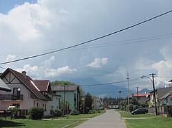
 Mlynčeky Village with the Tatras in the background. | |
| Etymology: 'Mlynček' means 'Mill' (as in millstone) in Slovak | |
 Mlynčeky Location in Slovakia | |
| Coordinates: 49°10′27″N 20°23′40″E / 49.17417°N 20.39444°ECoordinates: 49°10′27″N 20°23′40″E / 49.17417°N 20.39444°E | |
| Country | Slovakia |
| Region | Prešov |
| District | Kežmarok |
| Founded | 1890 |
| Government | |
| • Mayor | Milena Svocáková |
| Area | |
| • Total | 7.679 km2 (2.965 sq mi) |
| Elevation | 680 m (2,230 ft) |
| Population (2010) | |
| • Total | 652 |
| • Density | 85/km2 (220/sq mi) |
| Time zone | UTC+1 (CET) |
| • Summer (DST) | UTC+2 (CEST) |
| Postal code | 059 76 |
| Area code(s) | 052 |
| Website | http://www.mlynceky.sk/ |
Mlynčeky is a village and municipality in Kežmarok District in the Prešov Region of north Slovakia.
Geography[]
The municipality lies at an altitude of 680 metres and covers an area of 7.679 km² . It has a population of about 620 people.
History[]
The village itself was established in 1956. At the end of 18th century was just one watermill located at the place of present village. Afterwards a pub had been constructed. Then the Mlynčeky became a settlement and in 1956 it obtained village status.

Mlynčeky Municipal Building with Slovak, European Union and local flags in front
External links[]
Categories:
- Villages and municipalities in Kežmarok District
- Prešov Region geography stubs
